Tornado alley(s)
Jun 9, 2010 - by Staff
Early closure on July 3 and 4 - NSF NCAR Road, Parking Lot and Trails
View more information.Jun 9, 2010 - by Staff
9 June 2010 • A swath of the Great Plains from Texas to Minnesota has long been dubbed Tornado Alley, home to one of the world’s greatest concentrations of twister activity. But rather than one ominous alley, the nation actually has several avenues of enhanced tornado risk, as highlighted in a new analysis by University of Akron graduate student Michael Frates.
It’s no secret that many of the nation’s worst tornado swarms occur well east of the Great Plains. This includes the deadly Mississippi twisters on 24 April of this year and the largest 24-hour burst of tornadoes ever recorded, the Jumbo Outbreak of 3 April 1974. To help quantify his impression that the label Tornado Alley is a misnomer, Frates mapped the locations of twisters from 1950 to 2006 that were rated F3, F4, or F5 on the Fujita intensity scale. He identified four distinct clusters of action, located in the Plains, the Deep South, the Midwest, and the Carolinas (see map). Frates presented his work at the Association of American Geographers’ annual meeting in April.
“I received a wealth of positive feedback,” says Frates. He sees Dixie Alley as the most dangerous of the four zones, since tornadic storms can form there at any time of the year, and the dense settlements and forests make for more destruction. Frates notes that while the South’s trees—and its propensity for nighttime storms—make it harder to see tornadoes in progress, the thick vegetation does make it easier for survey teams to identify tornado paths and assign a damage rating.
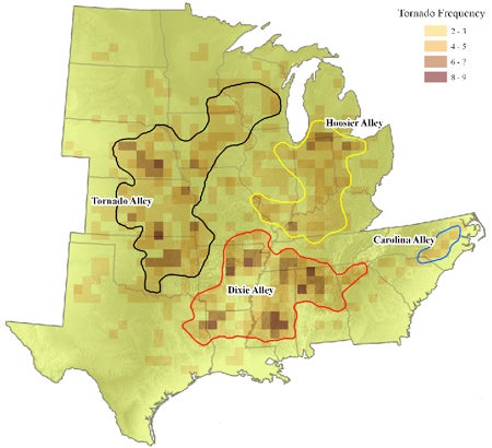 Shown above are the numbers of tornadoes rated F3 to F5 in each grid box that occurred from 1950 to 2006, along with the four areas of concentrated activity identified in a recent study at the University of Akron. (Illustration courtesy Michael Frates.)