HIPPO Multimedia Gallery - 2009
Jan 29, 2009 - by Staff
Temporary impacts to NSF NCAR Road, Parking Lot and Trails
View more information.Jan 29, 2009 - by Staff
Multimedia Gallery - 2009
For the latest on HIPPO, see:
HIPPO is a three-year field project that undertakes the most extensive airborne sampling of carbon dioxide and other greenhouse gases in the atmosphere to date, from the Arctic to the Antarctic.
Study results are helping scientists understand in greater detail the behavior of carbon dioxide and greenhouse gases in the atmosphere and eventually lead to improved predictions about climate change.
All images must be credited to UCAR and may be reproduced in news stories about NCAR & UCAR activities.
![]() Teleconferences featuring HIPPO scientists (February 4, 2009)
Teleconferences featuring HIPPO scientists (February 4, 2009)
![]()
A. Mapping C02 distribution across the globe
Britton Stephens, NCAR scientist and HIPPO co-principal investigator, describes the field project’s flight path and how the flights will help researchers determine carbon dioxide's influence in different regions of the globe.
(©UCAR, video by Carlye Calvin, animation by Steve Deyo.) News media terms of use*
![]()
B. A new picture of the atmosphere
Steven Wofsy, Harvard University scientist and HIPPO principal investigator, explains the significance of the HIPPO missions, which allow scientists to look at the whole globe at once in great detail. When the project is complete, scientists will have a new picture of how greenhouse gases are entering and exiting the atmosphere as a result of natural processes and human activities.
(©UCAR, video by Carlye Calvin and courtesy National Science Foundation.) News media terms of use*
![]()
C. HIPPO’s flight path from the Arctic to the Antarctic across the Pacific Ocean
During the 20-day mission, the NSF/NCAR Gulfstream V research aircraft will fly at altitudes ranging from 1,000 to 47,000 feet as it samples atmospheric greenhouse gases. The jet aircraft, called HIAPER, flies out of Boulder, Colorado, to the Arctic and across the Pacific Ocean to Antarctica via Anchorage, Alaska; Honolulu, Hawaii; Pago Pago, American Samoa; Christchurch, New Zealand; Tahiti, French Polynesia; and Easter Island, Chile.
(©UCAR, animation by Steve Deyo.) News media terms of use*
![]()
D. More accurate predictions for climate change
Britton Stephens, NCAR scientist and HIPPO co-principal investigator, explains how the research project will enable scientists to make better predictions about global warming in the future.
(©UCAR, video by Carlye Calvin.) News media terms of use*
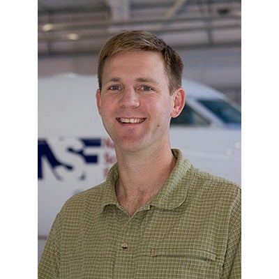
E. Britton Stephens
Click here or on the image to enlarge.
Britton Stephens, NCAR Scientist and HIPPO co-principal investigator.(©UCAR, photo by Carlye Calvin.) News media terms of use*
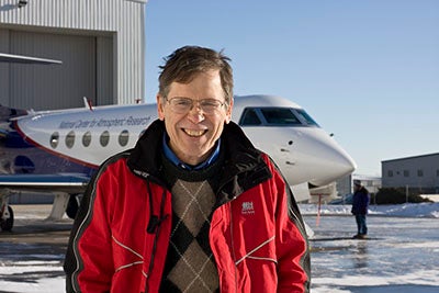
F. Steven Wofsy
Click here or on the image to enlarge.
Steven Wofsy, Harvard University scientist and HIPPO principal investigator. (©UCAR, photo by Carlye Calvin.) News media terms of use*
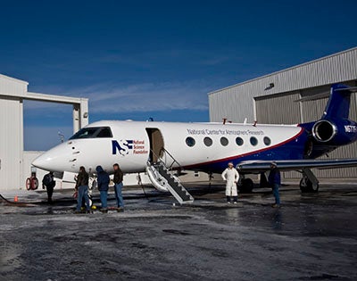
G. A flying environmental laboratory
Click here or on the image to enlarge.
The HIPPO missions rely on a specially equipped Gulfstream V aircraft known as HIAPER (High-performance Instrumented Airborne Platform for Environmental Research). HIAPER is owned by the National Science Foundation and operated by the National Center for Atmospheric Research. Specialized instruments for measuring atmospheric gases are mounted in pods under the wings, on the mainframe of the aircraft, and inside the cabin. (©UCAR, photo by Carlye Calvin.) News media terms of use*
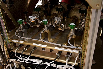
H. Sampling the atmosphere
Click here or on the image to enlarge.
One of the many atmospheric measurement instruments onboard the NSF/NCAR Gulfstream V research aircraft. The instruments measure atmospheric gases such as carbon dioxide and methane. (©UCAR, photo by Carlye Calvin.) News media terms of use*

I. Flying over the Arctic
Click here or on the image to enlarge.
This photo of the Arctic was taken from the HIAPER aircraft during the HIPPO mission. (©UCAR.) News media terms of use*
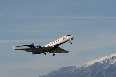
J. HIAPER takeoff
Click here or on the image to enlarge.
The NSF/NCAR Gulfstream V research aircraft, known as HIAPER (High-performance Instrumented Airborne Platform for Environmental Research). (©UCAR, photo by Carlye Calvin.) News media terms of use*