Helping satellites dodge space junk
Testing under way for system tracking space weather’s influence on orbits
Jul 2, 2014 - by Staff
Jul 2, 2014 - by Staff
July 2, 2014 | As two astronauts discovered in the hit film Gravity, encountering a stray bit of space junk can ruin your whole day. Space debris is more than a Hollywood plot device, though: it poses serious risks to a wide array of satellites critical to society. NCAR is part of a collaborative effort to help reduce those risks by modeling the effects of space weather on satellite orbits.
Commissioned by the U.S. Air Force and brought into testing mode this summer, the Atmospheric Density Assimilation Model (ADAM) takes into account real-time information on satellite tracks and space weather to predict future satellite paths as much as 72 hours in advance.

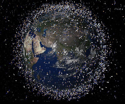
This artist's conception shows the broad scope of space debris circling the planet, hundreds of miles above sea level, at the same height where low-Earth orbit satellites operate. The spatial density of debris objects increases at high latitudes. The size of the debris elements in this image is greatly exaggerated compared to the size of Earth. (Image courtesy European Space Agency.)
The ADAM project is being spearheaded by the private firm ASTRA in collaboration with NCAR, the University of Colorado Boulder, and the National Oceanic and Atmospheric Administration’s Space Weather Prediction Center. “We’re pleased to lead such a stellar team,” said ASTRA chief scientist Geoff Crowley, who is heading the project.
“Space debris is a big problem for satellite operations,” said Liying Qian, NCAR’s principal investigator on ADAM. Another NCAR participant, Stan Solomon, noted that interest in the problem is on the rise: “There is more concern and awareness of space-junk issues, and more recognition that atmospheric drag is the major uncertainty in tracking it.”
Right now the Air Force tracks roughly 19,000 pieces of space debris, but there’s nothing that can be done to change any of their paths. Instead, satellite operators have to adjust spacecraft orbits to steer around the debris.
To project those orbital adjustments accurately, scientists need to know how the density of the atmosphere is evolving in the low-Earth orbit (LEO) zone, several hundred miles above the surface. Both everyday heating by the Sun and occasional solar storms cause the upper atmosphere to expand. This exerts added drag on LEO satellites, pulling their orbits closer to Earth. Atmospheric waves propagating from below can also influence upper atmospheric density, a topic now being studied in the DEEPWAVE field project.
Up to now, the Air Force has relied on climatologically based models to estimate near-term changes in atmospheric density, much as someone might use average highs and lows in a given city to make a rough guess about tomorrow’s weather. However, these climatological models can’t accurately account for erratic solar storms that can zip from the Sun toward Earth in less than two days, producing rapid changes in air density.
The ADAM system will draw on three upper-atmosphere models, two from NCAR and one from NOAA. “The Air Force has selected a dream team of thermospheric modelers to develop this advanced simulation tool,” said Crowley.
NCAR will provide ADAM with data on current solar activity as observed by NASA’s Solar Dynamics Observatory and NOAA’s Geostationary Operational Environmental Satellite network. A graphical interface will allow users to select input for ADAM, interact with the component models as they run, and monitor the output. Similar to NOAA hurricane guidance, ADAM will help users produce a cone of possible future trajectories of space debris, together with projected satellite tracks.
With the initial ADAM model now complete, the next phase is a round of testing that began in June and will continue through the summer of 2015 at the Air Force Research Laboratory. Once finalized, the system could eventually be used in both military and commercial settings.
|
Writer/contact Collaborating institutions |
Funders |