Nor’easter on the radar
Detailed airborne views of snowstorm could lead to better winter forecasts
Feb 9, 2015 - by Staff
Feb 9, 2015 - by Staff
February 9, 2015 | While some folks were looking to Punxsutawney Phil on Groundhog Day, scientists were learning about the weather through a different route: flying a highly advanced cloud radar on its maiden voyage above a major northeast storm.
The dual-polarization radar, developed at NCAR with funding from NSF, is a compact instrument that uses millimeter-long wavelengths of energy to provide highly detailed views of the atmosphere. It distinguishes between ice, water, and supercooled water droplets (droplets that exist as a liquid below freezing), measures thin ice and liquid clouds, and takes advanced wind measurements.

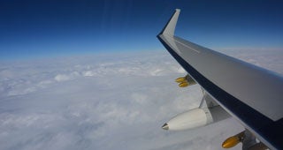
Scientists flew the new HIAPER Cloud Radar, mounted in the white pod, over a Nor'easter to capture detailed data about a major winter storm. (Photo by Jonathan Emmett, NCAR. This image is freely available for media & nonprofit use.)
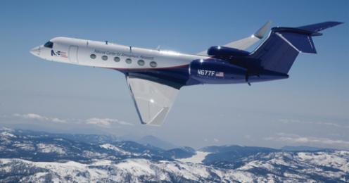
The new instrument is designed to fly aboard the specially instrumented NSF/NCAR Gulfstream V aircraft, also known as the High-performance Instrumented Airborne Platform for Environmental Research (HIAPER). For that reason, it is called the HIAPER Cloud Radar.
A scientific team led by University of Illinois atmospheric scientist Bob Rauber deployed the radar on February 2 for eight hours, gathering data from Washington, D.C., to Bangor, Maine. Flying over a storm that was pummeling the region with snow, freezing rain, and strong winds, the scientists obtained clear and detailed observations of various features within the storm, including circulation patterns and small regions near the top of the clouds called generating cells that contain up-and-down drafts and generate the snow that later reaches the ground.
The one-day field project, known as Nor’easter, will help scientists better understand the conditions that lead to the distribution of precipitation within the storm. It may eventually lead to finer-grained forecasts that can project which locations within a region are likely to receive the most snow.
Northeastern winter storms draw energy from warm Atlantic water, developing bands of exceptionally heavy snow. This creates a major forecasting challenge for the densely populated Northeast where the locations of such bands can mean the difference between a foot of snow falling on Manhattan or on less developed regions just 50 or 75 miles away.
“We are hoping to understand how the circulation patterns we saw so clearly on the HIAPER Cloud Radar organize snowfall,” Rauber said. “The data from the Nor’easter Project will be valuable to forecasters and researchers studying Northeast snowstorms, helping them interpret the computer model results and observations by ground radar.”
The research team was excited to put the new radar through its paces and said it passed its maiden voyage with flying colors.
“The HIAPER Cloud Radar, together with the long range and endurance of HIAPER, will allow atmospheric scientists the flexibility to explore regions of storms that would be impossible to reach with ground-based radars,” said Jeff Stith, manager of NCAR’s Research Aviation Facility. “For example, they can use it to study the formation of large storm systems approaching the East Coast from the Atlantic Ocean. We expect it to be widely used in future missions, often in combination with other measurements that can be made from HIAPER.”
The wait won't be long. The radar's next deployment will be this summer, when a field project known as CSET (Cloud-System Evolution in the Trades) gets underway. CSET researchers will head to the Pacific to examine the evolution of cloud systems in the important trade-wind regions, which can influence climate worldwide.

The NSF/NCAR HIAPER Gulfstream V research jet in flight. (©UCAR. This image is freely available for media & nonprofit use.)
Writer/contact
David Hosansky
Nor’easter Collaborator
University of Illinois
Nor’easter & HIAPER Cloud Radar Funder
National Science Foundation