Lows that just won't leave: Northeast braces for another wintry onslaught
Feb 25, 2010 - by Staff
Temporary impacts to NSF NCAR Road, Parking Lot and Trails
View more information.Feb 25, 2010 - by Staff
Bob Henson | 25 February 2010 • Like a cat toying with its prey, an intense area of low pressure is taking swipes at New England and the mid-Atlantic over the next several days. It’s clear that a lot of rain and snow will fall somewhere in the region, and winds could gust to hurricane force in some spots. But where, when, how much, and how strong?
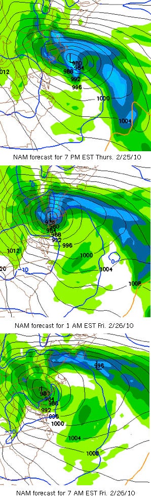 The North American Mesoscale Model (NAM) forecast issued on the morning of 25 February 2010 shows an intense and persistent storm close to New York City. (Images courtesy NOAA National Centers for Environmental Prediction.)
A look at the maps shows what forecasters are up against. On Thursday morning, 25 February, the workhorse North American Mesoscale Model (NAM) predicted that a surface cyclone, or low-pressure area, would dip to 972 millibars (about 28.70 inches of mercury) near New York City by early Friday morning. (See forecast map series at left.) That would rank among Gotham’s lowest pressures on record. The all-time mark was set on 1 March 1914, when Central Park’s air pressure dipped to 28.38” in the midst of a snowstorm that packed 72-mph wind gusts.
If it were located over the tropics, a cyclone as intense as the one predicted here could pass for a Category 2 hurricane on the Saffir-Simpson scale. AccuWeather dubbed the storm a “snowicane,” while others protested the terminology. This storm will indeed bring heavy precipitation, high winds, and possibly major damage to trees and limbs. The difference is that winds in a midlatitude cyclone like this one will generally be weaker, but spread over a larger area, than in a tropical cyclone that has the same minimum pressure.
Much like a stalled tropical cyclone, however, this storm isn’t going to scurry off anytime soon. Even on Saturday night, its center is predicted to hang in the Hudson Valley as it slowly weakens. The National Weather Service office for the New York City area is predicting a chance of snow from Thursday night through Monday—an unusually long period for the Big Apple to be seeing the white stuff.
Searching for a precedent
As major winter storms move off the East Coast, they often pause for a breather. Gaining a sudden infusion of energy from the relatively warm seawater, they can rapidly intensify, or turn into “meteorological bombs,” before continuing their eastward trek. It’s much less common for a winter storm to slide west over the northeast U.S. and park there for several days.
In fact, forecasters are struggling to find a system comparable to this one. At Saint Louis University, more than 20,000 historical weather scenarios are scanned by an online tool that finds and ranks the closest analogs to the near-term forecast at a given location. Normally, the system finds at least a few analogs from past years. But when I queried it this morning on the predicted setup for the Northeast U.S, I got the following response: "There are no analog matches for this forecast."
Human forecasters are finding the situation equally vexing, as shown in the online discussions posted by various National Weather Service offices. "Lots of disagreement in guidance as to the track of the drifting . . . spinning surface/upper feature," noted a forecaster in Albany, New York. "A very challenging forecast for the next 48 hours," said the NYC office. And forecasters in the Philadelphia area declared, "There is very little that is simple with this event."
As people from Washington to New York know well, it’s been a winter of intense cyclones along the mid-Atlantic coast, including the back-to-back, record-smashing snowstorms earlier this month. However, other parts of the country have dealt with unusually strong cyclones as well. In mid-January, the southwest U.S. saw one of the most intense lows in 140 years of record keeping. And the holiday storm that brought Oklahoma City and Wichita Falls, Texas, their heaviest one-day snowfalls on record (24 December) was so “wrapped up” that it was 48°F on the low’s north side, near Kirksville, Missouri, but 18°F in Moberly, only about 50 miles to the south, as noted in a detailed analysis from the Kansas City–area NWS office.
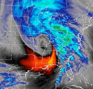 This satellite-derived image of atmospheric water vapor from the early morning of 25 December 2009 shows a tightly wrapped upper-level storm centered near southeast Missouri. The surface low was displaced slightly to the northwest (not visible). (NOAA GOES image courtesy NWS Kansas City–Pleasant Hill.)