Chasing tornadoes, armed to the teeth, for serious science
May 28, 2010 - by Staff
Temporary impacts to NSF NCAR Road, Parking Lot and Trails
View more information.May 28, 2010 - by Staff
David Hosansky | 28 May 2010 • You don't have to spend a lot of time in the Great Plains during storm season to realize how little we know about tornadoes.
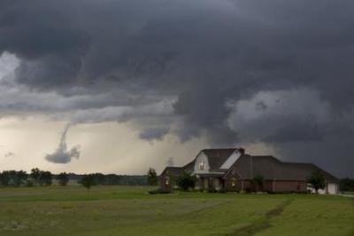
The sirens sound when the skies turn black and violent supercell thunderstorms roar through. But no one has yet been able to figure out with precision which storms will actually spin up a tornado, let alone where the tornado may hit or how destructive it may be.
As a result, forecasters can't give residents as much detail as they'd like to. Typically, the National Weather Service (NWS) issues watches—each spanning parts of one or more states—to alert residents that a tornado could strike sometime that afternoon or evening. When a tornado warning is actually sounded, residents only have 13 minutes on average to find shelter. And though forecasters can now highlight the most violent tornadoes with some confidence, tornado warnings in general have a 70 percent false-alarm rate.
While tornado forecasts are much more accurate than a generation ago, meteorologists want to do better. To that end, scientists are crisscrossing the Great Plains this spring, equipped with a multiplicity of instruments to analyze tornadoes in unprecedented detail. This research could eventually enable forecasters to generate warnings 30 minutes or more in advance, with much greater reliability.
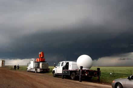 Known as VORTEX2 (short for the second Verification of the Origins of Rotation in Tornadoes Experiment), this is the largest-ever tornado field campaign, with field phases in 2009 and 2010. Its size is quite remarkable. To really understand tornadoes, and the supercell thunderstorms in which they're embedded, scientists need to surround the storms and observe them from a bewildering number of perspectives. A key goal is to measure atmospheric conditions—including temperature, humidity, and winds—throughout and around a storm to determine the precise conditions that will produce tornadoes.
I got to spend some time last week with the researchers as they pursued storms across Texas and Oklahoma. NCAR scientist George Bryan was overseeing several crews that use NCAR's Mobile GPS Advanced Upper-Air Sounding System (M-GAUS), which involves launching instruments called sondes on balloons to take atmospheric measurements in a supercell thunderstorm. While radars and other instruments can observe conditions near the surface, and satellites can peer down at cloud tops, the M-GAUS system enables scientists to collect data in a critical zone in the middle of the storm. Routine sonde launches by the NWS occur only twice a day and are separated by 100 miles or more.
Such information "tells us how stable or unstable the air is," Bryan explains. "It tells you whether the air is able to ascend in thunderstorms or whether something is inhibiting it. That's crucial."
Roger Wakimoto, a veteran tornado researcher who was recently appointed director of NCAR, is working with teams of researchers who use high-resolution digital cameras and specialized video equipment to better understand the structure of storms. By comparing images with radar data taken at the same time and place, scientists can answer such questions as whether a visible funnel cloud spins up in the same region as a storm's most intense winds. . This technique—photogrammetry—has been employed for decades, but the combination of new, high-resolution digital cameras and mobile radar data may provide a quantum leap in the quality of the results.
Wakimoto is also involved with efforts to survey damage caused by tornadoes, thereby establishing the "ground truth" of the impacts of different types of tornados.
Other VORTEX2 instruments include:
For a list of the impressive number of organizations involved in VORTEX2, see our April 28 news release.
And in addition to the photos on this page, you can view a slide show of people, mobile gear, and amazing skies by our photographer/videographer, Carlye Calvin. We also have b-roll for journalists of severe storms studied this spring by VORTEX2 scientists.
The primary responsibility for coordinating the field operations each day falls to David Dowell of NCAR and Erik Rasmussen of Rasmussen Systems. Working with meteorologists and other experts, they help develop a plan each day for locating and surrounding severe storms in regions where there are good networks of roads, but not too many trees or buildings to obstruct observations. Their operations center is mobile—a van that moves with the storms each day.
"It's a tremendous forecasting challenge," Dowell says, "And then it's a tremendous logistical challenge to get the teams in place."
So far the VORTEX2 team has successfully collected data on several supercell thunderstorms and tornadoes. This wealth of observations, which will keep scientists busy for years, will transform our understanding of tornadoes—and how to keep residents safe from them.
Want to keep up with VORTEX2? Follow the campaign on Facebook or Twitter.