Postwar pioneers: Reflections on the roots of modern atmospheric science
Jun 9, 2010 - by Staff
Temporary impacts to NSF NCAR Road, Parking Lot and Trails
View more information.Jun 9, 2010 - by Staff
9 June 2010 • This year a number of institutions that have made major contributions to the atmospheric sciences are celebrating key anniversaries. These include NSF’s 60th, NCAR and UCAR’s 50th, and the 20th anniversary of UCAR’s COMET program, which trains operational meteorologists. Two of the largest U.S. meteorology programs are hitting milestones of their own this year: Pennsylvania State University’s 75th and the University of Oklahoma’s 50th. In addition, 2010 marks the 60th anniversary of the first numerical weather forecast and the 50th anniversary of the launch of the first weather satellite, TIROS 1.
 UCAR president Richard Anthes.
Anniversaries serve as convenient windows for reviewing accomplishments and looking toward the future. The fact that so many major anniversaries in our community coincide this year, early in a new decade, provides ample motivation to reflect on the path that brought us here. How did technologies such as numerical models and satellites, and institutions such as NCAR and UCAR, take shape?
As World War II ended in 1945, all three components of meteorology—theory, observations, and applications (i.e., weather forecasting)—were individually weak, and there was little linkage among them. Atmospheric observations were sparse, and theories were primitive. The few university departments in meteorology were fragmented, and weather forecasting was much more of an art than a science. There were almost no private-sector meteorologists. Indeed, meteorology was a strong contender for the label that Thomas Carlyle gave to economics in 1849: the “dismal science.”
Shortly after the war ended, an unprecedented boom in science and technology began, and atmospheric research was at the heart of it. After five years of preparation, the first numerical weather forecasts were made on an ENIAC computer in Princeton, New Jersey, on 5 March 1950. Crude as they were, they pointed to amazing potential. Much more on the rich history of numerical weather prediction can be found in a fascinating 2008 book by Kristine Harper, Weather by the Numbers. Harper concludes her history with the following assessment (pp. 235–36):
The introduction and acceptance of numerical weather prediction was the great watershed of twentieth-century meteorology. Numerical weather prediction provided a technique and way of thinking that represented a fundamental discontinuity in meteorological theory and practice and transformed meteorology from a marginal scientific backwater to a rigorous science at the forefront of scientific discourse within 20 years. Due to numerical weather prediction, meteorology developed a robust theory, established a strong academic presence, experienced a rapid increase in the availability of research funds, and saw graduate-school trained meteorologists remake the nation’s weather services into respected, professional organizations.
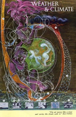 This cloud painting, commissioned by Harry Wexler, was the centerpiece of a weather and climate poster issued during the International Geophysical Year, 1957–58. The poster is available online from the National Academies.
The view from above
In addition to his early recognition of the potential for computers to forecast the weather, Harry Wexler—director of research for the U.S. Weather Bureau—was also thinking about weather satellites and what Earth and its cloud systems would look like from space. Today, with satellite imagery available in seconds from virtually any networked computer and even on a smartphone, it is hard to imagine what life was like for 1950s-era meteorologists who had never seen a crisp, clear image of Earth from space.
Wexler commissioned an artist (name unknown) to paint a picture of what Earth might look like from a point 4,000 miles (6,437 kilometers) above Amarillo, Texas, on 21 June (Fleming, 2007). This imaginative work of art was based on surface observations of clouds and a few cloud photos taken from rockets and balloons beginning in 1945. The painting became the centerpiece of a weather and climate poster issued during the International Geophysical Year (1957–58).
The universities and the “grand experiment”
As progress was being made on numerical weather prediction and satellites in the late 1950s, a group of farsighted scientists and university professors was thinking about how to address the weaknesses in meteorological research and education in the country. In 1956, the president of the National Academy of Sciences, Detlev Bronk, appointed a Committee on Meteorology, chaired by Lloyd Berkner (president of Associated Universities, Inc.) and Carl-Gustav Rossby (University of Chicago and International Meteorological Institute at Stockholm) to “consider and recommend means by which to increase our understanding and control of the atmosphere.”
By early 1958, the committee had identified several problems and challenges.
• Research support was unreliable.
• Government funding, which was mostly from the military at the time, was aimed at applied rather than basic research.
• Atmospheric problems tended to be large and complex, requiring interdisciplinary research and large and expensive facilities.
• Research projects tended to be isolated rather than coordinated, and education and training were lacking.
The committee recommended a significant increase in basic research and the formation of a National Institute for Atmospheric Research (NIAR), to be operated by a consortium of universities with support from NSF. The first meeting of the UCAR Board of Trustees occurred on 2 April 1959 at the University of Arizona.
In April 1960, the UCAR Trustees appointed Walter Orr Roberts as the first director of NCAR. (The name had been changed because NIAR spelled backwards was not deemed to be auspicious for the new center!) What Penn State professor John Dutton described in the report UCAR@25 as “a grand experiment” had begun. For more on UCAR’s history, see UCAR@25 and other summary documents linked on the UCAR Highlights page, as well as the upcoming report UCAR@50—which will be sent to UCAR Magazine subscribers later this year—and our 50th anniversary Web site.
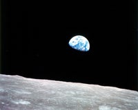 In December 1968, Apollo 10 astronauts captured a photo of “earthrise” above the surface of the Moon. Such images had a profound effect beyond science: by vividly showing the beauty and uniqueness of our planet, they helped trigger the modern environmental movement. (Photo courtesy NASA.)
The long view of Earth
Shortly after the IGY painting, the Television Infrared Observation Satellite 1 (TIROS 1) was launched from Cape Canaveral, Florida, on 1 April 1960, and we saw for the first time real clouds from space. Perhaps the greatest scientific contribution of all the Earth satellites since TIROS 1 has been that of giving a true global perspective to weather and to all components of the Earth system.
Models were continuing to develop as well, and weather forecasts were improving as a result. Precipitation probabilities were added to U.S. weather forecasts in the mid-1960s. In addition, the first signs of tighter coordination between observations and modeling were beginning to appear.
In 1965, only five years after the formation of NCAR and the launch of the first weather satellite, NCAR hosted a major workshop involving many of the luminaries in the meteorology and emerging satellite meteorology communities. The papers presented at this workshop and list of participants were published in an NCAR Technical Note in 1966 (see “On the Web”). One of the speakers, Verner Suomi (see below), made the following prediction, which may have come as a surprise given his status as the “father of satellite meteorology:”
In discussing the general circulation it occurred to me that when, some ten or twenty years from now, the history of meteorology will be written, there may be a comparison between the contribution made by the satellite and that made by the computer. I do believe that when that history is written it will be the numerical model that will be the biggest discovery or invention.
Whether Suomi was right or wrong about the relative contributions of satellites and computer models is today merely an interesting academic question. What is undeniable is that both have changed the way we look at weather and climate and how we do science and predictions. The rapid development of sophisticated data assimilation techniques in recent years has bridged these two revolutionary pillars of our science. Models now benefit greatly from satellite observations, and in turn, models are essential for validating those data and assisting in interpretation and retrievals of raw satellite data.
The future of numerical weather prediction, weather satellites and of UCAR and NCAR must have been promising but rather uncertain in 1960. Certainly much of what has happened since then was not entirely foreseen. However, it seems a safe bet that the visionaries who supported numerical weather prediction, weather satellites, and the novel concept of a university-run national center in the 1950s and 1960s would be proud today.
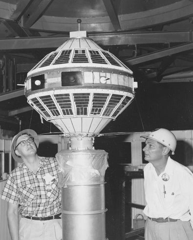 Verner Suomi (left) and Herman LeGow inspect the Explorer 7 satellite, launched in 1959. It included one of the first instruments to measure incoming ultraviolet radiation from the Sun and outgoing short-wave radiation from Earth. (Photo courtesy NASA.)
Satellites, modeling, and my own career
In the fall of 1967 I was just starting graduate studies at the University of Wisconsin–Madison. I was encouraged by my advisor, Donald Johnson, and other faculty members to take a course taught by Verner Suomi. Suomi was an incredibly enthusiastic teacher, but I admit I found it hard to follow his brilliant but somewhat disjointed ideas. At this time ESSA (Environmental Science Services Administration, the precursor to NOAA) was getting photographs from TIROS 10 and three other satellites (ESSA 1, 2, and 3). Suomi somehow obtained hard copies of some of these photographs, probably mailed by special delivery from Washington. By the time they reached our class they were typically one or two days old. The low-resolution photos tended to be fuzzy, and unless they happened to include easily recognizable geographic features such as the Great Lakes or the Florida peninsula, it was difficult to identify the locations they portrayed. Still, they were of great interest because of the future they promised.
I had already started my master’s degree research on isentropic modeling of hurricanes, so I did not pursue satellite meteorology at that time. However, some 25 years later I became interested in sounding Earth’s atmosphere using the novel technique of radio occultation (RO). At a time when most meteorologists had never heard of RO, Suomi—now near the end of his incredible life—had already grasped the power of this new technology and was enthusiastically touting its advantages. He was a great source of encouragement in the early 1990s to those of us developing an RO-based project, GPS-Meteorology. Fortunately Suomi lived long enough to see the first radio occultation sounding of Earth’s atmosphere; he died on 30 July 1995, only a few months after the launch of GPS-MET on 3 April.
After my initiation to Suomi and satellites in 1967, my modeling research spanned some 20 years and included hurricane modeling at NOAA, the development of the five generations of the Penn State/NCAR Mesoscale Model (MM1-MM5) with a large number of students and colleagues at both institutions and elsewhere, including Tom Warner, Bill Kuo, and many others. The MM experience was rewarding in many ways, perhaps most notably in the validation of our hypothesis that many mesoscale phenomena, including fronts, squall lines, tropical cyclones and their associated precipitation patterns, were predictable days in advance. The gradual acceptance by the international community of the freely available MM series was also satisfying. In time, we had a large cadre of smart students and scientists around the world who were, in a sense, working with us—testing the model under different conditions, finding errors and weaknesses, and proposing model improvements.
By the mid-1980s, I was pretty much occupied with full-time administration at NCAR and UCAR, but I was delighted to see the promise of GPS-MET fulfilled and the value of RO demonstrated in numerical weather prediction, space weather, and climate in the COSMIC program (Constellation Observing System for Meteorology, Ionosphere & Climate). I also “returned” to Earth satellite matters as co-chair, with Berrien Moore, of the National Research Council report Earth Science Applications from Space, which evaluated options for the next decade of U.S. environmental satellites. The report was published in 2007, just over 40 years after I took Suomi’s satellite meteorology course.