Hurricanes in the making
Parallel field studies gain the best look yet at incipient tropical cyclones
Nov 2, 2010 - by Staff
Temporary impacts to NSF NCAR Road, Parking Lot and Trails
View more information.Nov 2, 2010 - by Staff
2 November 2010 • It’s not exactly a moment for celebration, but when a tropical storm is born in the Atlantic, millions of people learn about it quickly. As with any birth, though, a great deal has to happen in just the right way before a tropical storm is christened.
Most tropical storms take shape after spending a few hours to several days as a tropical depression, a quasi-closed circulation whose peak sustained winds haven’t reached the threshold of 63 kilometers per hour (39 miles per hour). For every tropical disturbance that makes it to the depression stage, several more in the Atlantic are snuffed out by wind shear, dry air, and other influences. Both winners and losers in this battle got their six weeks of fame—at least among researchers—in 2010. Aircraft from several agencies spent much of late August and September flying in and around embryonic disturbances, while computer models tracked the circulations and assessed their odds of developing.
Working in tandem, three studies canvassed the tropical Atlantic this year, shown here with their primary funders:
Each project evolved on a separate timeline, with its own goals and instruments, but the three were closely linked. Scientists for each project shared insights and rotated forecasting duties, and the teams synchronized their flight plans with coordination calls twice per day, plus near-continuous exchanges by email.
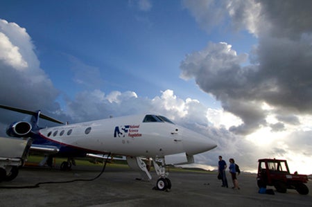
The NSF/NCAR Gulfstream V prepares for an early-morning flight from the St. Croix airport.
“I have never observed such extensive and constructive collaboration between agencies in the planning and carrying out of this kind of field program,” says Edward Zipser (University of Utah). A principal investigator for GRIP, Zipser has nearly five decades of experience in tropical field studies.
The atmosphere itself was also well synchronized with the three studies. With the tropical Atlantic simmering at near-record warmth, and an unusually strong La Niña taking shape, the preconditions were as good as they get. After a quiet start, activity began to bubble toward the end of August. By late September, the projects had gathered exhaustive multiday profiles of the formation of two hurricanes (Earl and Karl), a destructive tropical storm (Matthew), another that was harmless but long-lived (Fiona), and a remnant tropical storm that never revived (Gaston). If analysis goes as well as planned, the results could enhance the ability of forecasters to pick out future hurricanes and weed out doomed systems days in advance.
The problem facing hurricane forecasters and theoreticians alike is aptly stated in the PREDICT project summary: “The formation of tropical cyclones remains one of the great unsolved problems in meteorology.” Once a tropical storm takes shape, track models are increasingly skilled at projecting its path (see related article, "Never in doubt."). The prediction of intensity remains much more difficult, though. That’s especially the case for incipient disturbances that might or might not become tropical cyclones at all.
At the Naval Postgraduate School (NPS), Michael Montgomery, PREDICT’s lead principal investigator, and his research group, including colleague Timothy Dunkerton (NorthWest Research Associates), have spent the last few years grappling with this longtime challenge. Earlier work had made it clear that convection (showers and thunderstorms) is an essential ingredient. Deep layers of moisture are needed in and near the disturbance in order to nourish this convection. And wind shear (the change of winds with height) must be light to keep a system from being torn apart.
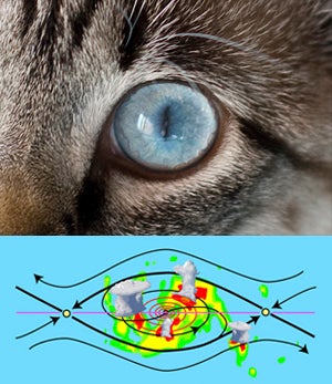
The flow in and near an incipient tropical cyclone resembles a cat’s eye on its side, with air circulating inside a protected region where convection and rotation can consolidate. (Illustration courtesy Michael Bell.)
Around 60 disturbances each year move westward across the tropical Atlantic during a typical hurricane season. Many look promising, but only about 20 percent make the transition to tropical depressions, at which point they’re likely to become tropical storms. Why, then, do so many disturbances fail to develop? Montgomery and colleagues knew that disturbances can take many forms on the larger scale, but they focused on atmospheric waves rolling westward through the Atlantic’s deep tropics.
Like waves atop the sea, these systems travel just north of the richly moist ribbon of air known as the intertropical convergence zone, pulling in an umbilical cord of moisture. When the waves move at the same speed as the encompassing flow, a protected region develops—often called the Kelvin’s cat-eye circulation (see graphic) or nonlinear critical layer—that embraces the formative elements of a tropical cyclone. The metaphor that took hold for Montgomery and Dunkerton was the marsupial pouch in which a young kangaroo develops.
“We think the marsupial pouch provides a focal point or ‘sweet spot’ where favorable conditions could persist for several days and where rotating thunderstorms are most likely to aggregate into a larger-scale storm,” says Montgomery. Not all of his colleagues were enraptured with the analogy, says Montgomery, “but we’re actually proving that it has strong scientific merit.”
In a study reported in the journal Atmospheric Chemistry and Physics, Dunkerton and Montgomery, plus Zhuo Wang (University of Illinois at Urbana-Champaign), found pouches in 55 of 61 tropical storms and hurricanes that had roamed the Atlantic and Pacific between 1998 and 2001. The marsupial hypothesis gained further traction through a Pacific field study called Tropical Cyclone Structure–2008, and NPS’s Mark Boothe and doctoral student Robert LeeJoice applied techniques developed for the Pacific study to identify and track pouches in the output of computer forecast models.
What’s inside the pouch is equally important. For a cyclone to develop, it appears that small pockets of rotation and convection need to coincide, thus strengthening both as well as bolstering the larger disturbance. These processes unfold on too small a scale to be monitored routinely, but PREDICT, IFEX, and GRIP were ideally positioned to take a closer look.
At the PREDICT operations center, located on the north coast of St. Croix, forecasters and researchers huddled each morning to look over the day’s data and make flight plans. Similar scenes unfolded at the Fort Lauderdale International Airport for GRIP, and at MacDill Air Force Base near Tampa for IFEX, whose flights overlapped with routine Air Force and NOAA reconnaissance missions into tropical cyclones.
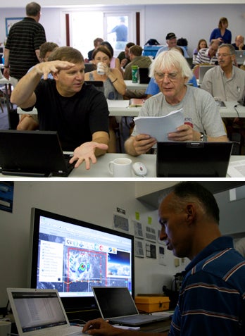
Above: Principal investigators Christopher Velden (University of Wisconsin–Madison) and Roger Smith (University of Munich) discuss tropical cyclone dynamics at the PREDICT operations center
Below: PREDICT nowcaster Derrick Herndon (University of Wisconsin–Madison) keeps an eye on thunderstorms building close to the flight path of the Gulfstream V.
The teams had a wealth of new analysis tools at their disposal. Along with the “pouch products” developed by Boothe and LeeJoice, they drew on more than 250 model runs each day from ensembles developed by Ryan Torn (University at Albany, State University of New York), Sharan Majumdar (University of Miami), and Fuqing Zhang (Pennsylvania State University). Torn’s ensemble employed initial conditions generated with NCAR’s Data Assimilation Research Testbed, then used the Weather Research and Forecasting model to generate PREDICT-specific output, including the probabilities of pouch quantities exceeding relevant thresholds. The pouch products and longer-range forecasts helped PREDICT gain the flight approvals needed from a web of jurisdictions spanning the Caribbean and western Atlantic.
“The forecasts were excellent from day one,” says Albany’s Lance Bosart, who joined other faculty as well as postdoctoral researchers and graduate students in calling the meteorological shots. Sometimes the prediction took patience, as with Hurricane Karl, which took several days to develop. “I was a day too soon in predicting Karl’s formation,” says Bosart. However, he adds, “The track was well forecast, and the storm was well sampled from the pre-genesis period through the Category 3 hurricane stage. We obtained excellent research datasets.”
GRIP benefited from a brand-new observing platform: NASA’s Global Hawk, a remotely piloted vehicle. After tests in the Pacific, the Hawk made its first flight into a hurricane by slicing through Earl on 2 September. With its range of 11,000 nautical miles (20,000 kilometers), the aircraft gathered data continually for up to 13 hours at a stretch, providing a sorely needed look at hurricane evolution on both short and long time scales. The project also tested a system developed at NCAR that will soon allow the Global Hawk to deposit dropsondes (parachute-borne instrument packages) on command. “It’s clear that the Global Hawk will be an amazing tool for studying tropical cyclone formation,” says Albany’s John Molinari.
PREDICT gave the NSF/NCAR Gulfstream V some of the most intensive workouts in its five-year history. Only a year after retiring, veteran NCAR pilot Henry Boynton returned to the skies for PREDICT, accompanied by longtime colleague Lowell Genzlinger. The presence of a second crew headed by pilots Joseph McClain and Stephen Thompson allowed for five consecutive days of G-V coverage on two prolonged systems.
As they circled around and through pouches, the G-V pilots got the kind of customized weather guidance that most commercial pilots only dream of. A group led by Christopher Velden at the Cooperative Institute for Meteorological Satellite Studies (NOAA/University of Wisconsin–Madison) brought real-time, high-frequency satellite data and derived products into a large-format display developed at NCAR that showed the G-V’s flight path (see photo). The mission coordinator and scientist on board the aircraft could see the same real-time display as the forecasting team on the ground, which helped them guide the pilots around thunderstorms and gather prime data while staying safe.
”The combination of real-time satellite products, data displays, and chat communications with the operations center gave us a great capability to adjust our flight patterns on the fly in the dynamic pre-hurricane environment,” says Michael Bell (NPS/NCAR), who served as a principal investigator and a G-V mission scientist.
Students played meaningful roles across the spectrum of field work at PREDICT. “It’s been exciting to apply cutting-edge analysis tools used to understand tropical cyclone formation in an operational setting,“ said Heather Archambault, a graduate student at Albany and a lead forecaster for PREDICT. “This has been one of the best educational experiences I’ve had.”
According to Velden, ”Many times in these high-powered field programs, the students are invited along as a learning experience and end up playing passive onlookers while the mentoring scientists lead the charge. But there was a significant, measurable contribution from the student involvement in PREDICT, from forecasting to decision support to aircraft flight tasks.”
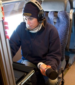
NCAR technician Laura Tudor prepares a dropsonde for launch.
Storm after storm
The PREDICT/GRIP/IFEX trio made the most of the stream of tropical cyclones that traversed the Atlantic this year. A couple of the season’s first hurricanes developed too quickly and too far east for the projects to document, but September brought a rapid-fire string of successful sorties.
Hurricane Earl was a particular success for GRIP’s rapid intensification component, as the system quickly grew to Category 4 intensity just north of the Caribbean before recurving off the U.S. East Coast. NASA’s DC-8 made four flights into Earl over five days, while NOAA’s Gulfstream IV and two P-3 aircraft sampled the storm and its environment with 18 research flights. Another dozen or so flights were deployed by the Air Force’s fleet of C-130 hurricane hunters. “By any measure, this is the best data on rapid intensification ever obtained,” says Zipser. (Earl also gave the PREDICT ground team a jolt of adrenaline as it moved north of St. Croix. The outer bands of the quickly strengthening storm brought debris-tossing gales to the operations center, forcing the staff to seek higher ground for a time in the hurricane-shuttered restaurant of their hotel.)
Along with capturing Hurricane Karl, as noted above, PREDICT gathered ample data on the birth of Tropical Storm Matthew across the southern Caribbean. The prolonged demise of Tropical Storm Gaston provided an equally valuable but much different case. Only a day after being named, Gaston diminished to a remnant low in the tropical Atlantic. At one point the NHC gave the remnants an 80% chance of reviving, but those odds slowly dropped as the system limped into the Caribbean and finally decayed. “Gaston continued to struggle even though it seemed like a viable disturbance for a long time,” says PREDICT PI Christopher Davis (NCAR). “It could teach us a great deal.”
Daily flights during the process made Gaston the most thoroughly observed case of failed tropical cyclogenesis in history, as well as a perfect “null case” for PREDICT: why didn’t the system redevelop?

NASA’s DC-8 shuttled to St. Croix for a flight into the remnants of Tropical Storm Gaston on 7 September. (Photo by John Cowan, NCAR.)
“The depth of the pouch seemed to diminish with time,” according to Montgomery. “There was strong shear from the east, and a lot of dry air was going over it.” If Gaston’s apparent top-down decay is confirmed, it could lend support to the bottom-up development model favored by Montgomery. It’s one facet of a longstanding debate over the vertical sequence of tropical cyclone formation that PREDICT may help settle.
As for forecasting, Montgomery and collaborators would like to see the new pouch-prediction model output added to the arsenal of tools used by NHC forecasters to help save lives and property. This year’s field work could also benefit NOAA’s ten-year Hurricane Forecast Improvement Program, which aims for a 20% improvement by 2013 in the accuracy of NHC’s five-day hurricane track and intensity forecasts. Another goal is to extend hurricane forecasts to seven days.
In order to stimulate progress in long-range prediction, the PREDICT and GRIP teams will need to analyze the data they’ve gathered this year from the difficult-to-observe areas within pouches where the biggest uncertainties lie. “Satellite pictures don’t tell you everything,” Montgomery notes. “The models have a lot of skill at predicting where the pouches are, but they don’t have a lot of skill at predicting what’s going to happen within the pouches. That’s why we’ve been collecting data.” These observations, he adds, should help solve the mystery of why some storms thrive in their protected regions while others struggle to survive.
—Bob Henson
For students, dusty air is pay dirt
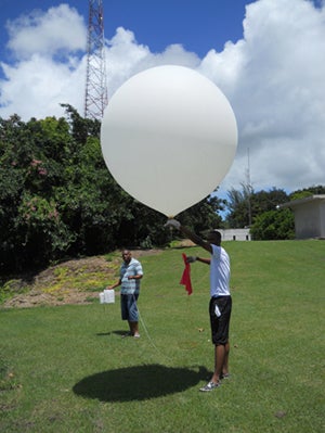
Ashford Reyes (University of the West Indies) and Adriel Valentine (Caribbean Institute for Meteorology and Hydrology) prepare to launch an ozonesonde. (Photo by Greg Jenkins.)
Ingesting a batch of dust-laden air from the Sahara can mean death for a tropical disturbance that relies on moisture to thrive. Giant plumes of dust often migrate west from Africa just north of the main hurricane development region, sometimes muscling into easterly waves. Forecasters now track these intrusions, but it’s not yet clear whether the dryness, the dust itself, and/or vertical shear interact to inhibit cyclone formation.
An international deployment organized by Gregory Jenkins (Howard University) and supported by NSF and NASA sent undergraduate and graduate students across the tropical Atlantic this summer to sample easterly waves, Saharan dust, and ozone. Students from Howard and Hampton universities, all from underrepresented groups, launched ozonesondes (ozone-measuring weather balloons) from Cape Verde, Senegal, and Barbados.
Observations in late June and early July centered on the Saharan Dust Layer. Participants watched for dust outbreaks to be predicted by the Weather Research and Forecasting–Chemistry model and its GOCART module (Goddard Ozone Chemistry Aerosol Radiation and Transport), developed at NASA’s Goddard Space Flight Center. The focus shifted to easterly waves during the project’s second phase, which coincided with PREDICT, GRIP, and IFEX. As the system that became Hurricane Karl took shape, soundings were launched every three hours from Barbados to enhance the data collected by the tri-agency group.
“The team in Barbados had the fortune of measuring ozone associated with several tropical cyclones as they passed to the north of the island,” says Jenkins. He and his Howard colleagues Belay Demoz and William Stockwell are working with students to get results from the summer’s work published in journals, presented at conferences, and expanded into theses and dissertations. Next up: a mini–field campaign in 2011 to measure dust outbreaks in the spring and compare them to last summer’s.