Getting the most from research radar
Workshop explores where the technology is heading
Feb 28, 2013 - by Staff
Temporary impacts to NSF NCAR Road, Parking Lot and Trails
View more information.Feb 28, 2013 - by Staff
February 28, 2013 | They’ve been carried by truck into supercell thunderstorms and flown on aircraft into hurricanes. They’ve sliced and diced the atmosphere in ways that would have astounded meteorologists a generation ago. So where are research radars headed next, and where will they take science and society?
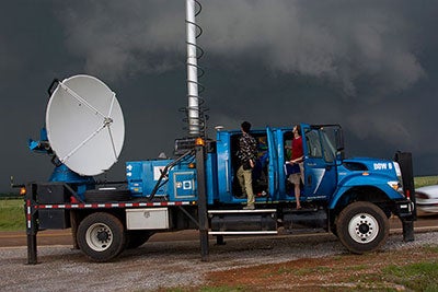
A Doppler on Wheels radar unit operated by the Center for Severe Weather Research samples a severe thunderstorm in the Texas Panhandle on May 18, 2010, during the VORTEX2 project. (©UCAR. Photo by Carlye Calvin. This image is freely available for media & nonprofit use.)
A workshop held at UCAR’s Center Green campus in November put these questions on the front burner. More than 100 scientists from five nations gathered for the three-day meeting. It was organized by the National Science Foundation, which funds a wide variety of research radars.
“Our main goal was to create a forum for community input on the most important scientific issues and questions that will be addressed in the next decade or so, and the role of radar technologies in solving those problems,” says Linnea Avallone, NSF program manager for Lower Atmosphere Observing Facilities.
The meeting was packed with both pressing research topics and promising technologies. “It was a very spirited, very wide-ranging workshop,” says Howie Bluestein (University of Oklahoma), who chaired the meeting.
Brad Smull, NSF’s program director for physical and dynamic meteorology, points out that research-grade radar platforms were once confined to a few large institutions. In a survey conducted on behalf of the workshop, NSF verified that things have changed in a big way. “We found a striking increase in the number and variety of these systems,” says Smull. “They are now routinely operated even by smaller universities and federal or state research groups.”

Howard Bluestein (University of Oklahoma) chaired the workshop on research radar technologies. (©UCAR. Photo by Carlye Calvin. This image is freely available for media & nonprofit use.)
The result is a true wealth of observing options, with more on the way. But are these well matched to the research priorities of today and tomorrow? And how can NSF best serve the research community in providing the kinds of radar resources that smaller entities can’t easily muster? While the questions remain open, workshop attendees pointed to some potential answers.
As Vanda Grubišić, head of NCAR’s Earth Observing Laboratory (EOL), puts it: “An ideal research radar suite of the future will be multiplatform, multiwavelength, and either mobile or transportable.”
Of course, there’s also got to be an accessible home for all the information gathered. A recurring theme at the workshop was the need for a more cohesive set of tools for analyzing, storing, and accessing radar data. “This is an old problem—everyone has his or her own software,” says Bluestein. EOL is now leading a community-driven effort to develop such a suite of tools that goes by the name of LROSE, Lidar Radar Open Software Environment. (See details in the 2012 EOL Annual Report.)
Once considered a novelty, mobile radars are now the norm. In contrast to the fixed radars used for routine weather monitoring, most research radars now move from place to place, often collecting data en route.
Vehicle-mounted Doppler radar came into its own in the 1990s. Bluestein and colleagues from the University of Massachusetts initiated a series of mobile radars that continues to evolve. Meanwhile, Joshua Wurman (Center for Severe Weather Research) built the first Doppler on Wheels units, which became familiar to many TV viewers through their starring role in the Discovery series “Stormchasers.” These systems—as well as mobile Dopplers created by several other partnerships—have transformed knowledge of tornadoes, hurricanes, and other fast-changing, small-scale weather events.
In the 1980s, Doppler radar took to the skies with the debut of a tail-based unit located on a NOAA P-3. It was followed in the 1990s by ELDORA (the Electra Doppler Radar), built jointly by NCAR and French scientists and engineers. ELDORA proved its value in a variety of research settings around the world as one of only three airborne Doppler radars available to U.S. researchers. (The other two, aboard NOAA P-3 aircraft, are often tied up with hurricane hunting duties.)
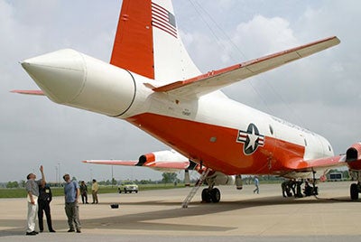
After a decade aboard NCAR's Electra aircraft, the Electra Doppler Radar was moved in 2001 to the tail of this P-3 aircraft operated by the Naval Research Laboratory. The P-3 was retired in late 2012. (©UCAR. Photo by Carlye Calvin. This image is freely available for media & nonprofit use.)
After two decades of service, ELDORA is now off the plane and on the ground at NCAR’s Foothills Lab. When NCAR’s Electra aircraft was retired in 2001, the radar was moved to a P-3 aircraft operated by the Naval Research Laboratory. However, that plane was itself retired at the end of 2012, after which the radar was removed.
Scientists at the workshop concurred that an ELDORA-like radar is a critical piece of their observing arsenal. Technology advances would allow a successor to ELDORA to gather far more data from the skies, so NCAR is now exploring the option of a state-of-the-art airborne radar that would succeed ELDORA (more about APAR, the proposed radar, below). The challenges will not only be funding and building this new radar, but also finding ways to fill the observational gap during the process. “It might be five to ten years before a replacement airborne Doppler radar could be made available to the research community,” says Grubišić.
So far, the oceans are largely untouched by the explosion in mobile radars. Two major U.S. research vessels—NOAA’s Ron Brown and NSF’s Laurence M. Gould—are among only a handful that have Doppler radars available for university scientists. Given the importance of the marine influence on weather and climate, scientists at the workshop called out ocean-going Doppler radar as a potential priority.
Research radars are not only more mobile but also more versatile than ever. A traditional radar is limited by having only a single transmitter and receiver and a set wavelength. Another constraint is the need to mechanically change the antenna angles that allow it to scan a storm vertically and horizontally.
Some of these limits are falling by the wayside with the advent of radars that can multitask with ease. One example is multiwavelength radars. The longer its wavelength, the deeper a radar beam can penetrate into a storm. And with more than one wavelength, a radar’s ability to retrieve information on water in its various forms in the atmosphere increases.
Similarly, by adding polarization to a radar beam, such as on NCAR’s S-Pol, radars can distinguish raindrops and hailstones of various sizes, based on their shapes. Such radars are invaluable for spotting regions of damaging hail and potential flash flooding. Over the past year, the National Weather Service has converted most of its national radar network to dual-polarization technology.
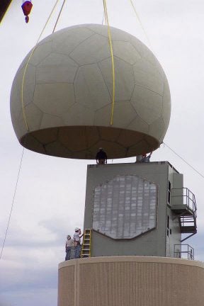
A traditional dome-shaped shelter is installed atop an experimental phased array radar in 2006 at the National Severe Storms Laboratory. (NOAA photo from Wikimedia Commons.)
One of the most promising technologies on the rise is phased array radar, in which the standard radar dish is replaced by a few dozens to thousands of transmitters and receivers, all spread across a rectangular plate (or even a cylinder, in one novel permutation). Like a set of many radars in one, phased array systems allow researchers to sample the atmosphere much more frequently, a crucial benefit in sampling tornadoes and other violent, mercurial weather events.
Another benefit to phased array technology is that it allows a radar to be mounted on an aircraft without significantly modifying the airframe. As a successor to ELDORA, NCAR has begun developing an airborne phased array radar (APAR) to be carried by the NSF/NCAR C-130 aircraft. A white paper is in the works, and collaborators will be sought as the proposal takes shape. Similarly, NOAA has expressed interest in having phased array capabilities in a future airborne Doppler radar on their own aircraft in order to gather unique data from within hurricanes.
Smart data processing can stretch a radar’s abilities even more. A new technique called adaptive scanning anticipates and prioritizes the radar beams most likely to strike key parts of a storm. In one recent test, the technique shaved 40% off the nearly two minutes needed to gather just one slice of imagery from a severe storm.
Other technologies are on the horizon, as outlined by the University of Oklahoma’s Robert Palmer. The cost of building a radar might drop dramatically if new solid-state techniques for compressing radar pulses live up to their promise. And in an experimental OU system called atmospheric imaging radar, a single radar pulse can be digitally deconstructed into many simultaneous beams upon receipt, producing an instantaneous cross section of a storm as often as three times per second.
The widening capabilities of research radar will bring a broad array of science questions within reach, as outlined by Robert Rauber (University of Illinois at Urbana-Champaign). Some of those will cross the traditional lines between weather and climate.
“Global change impacts will progressively drive scientific research over the next two decades,” notes Rauber. He foresees that the expected rise in heavy precipitation events and other types of weather extremes will help to drive the weather research agenda. Future mobile radars could gather far more precise data on atmospheric moisture. And weather prediction models will be able to incorporate radar data more readily, helping to improve model quality and forecast skill.
At the same time, the distinctions between global and regional atmospheric modeling will blur, as global models become increasingly able to depict features that are small enough for radar to observe. This interplay will help connect the dots between such phenomena as organized thunderstorm clusters in the tropics and winter storms in midlatitudes.
With vastly improved speed and detail, tomorrow’s radars could help unlock perennial mysteries about processes that unfold in a matter of seconds, such as tornado formation and ice crystal development. However, says Rauber, that potential could be lost if it remains as difficult as it is now to get researchers and radars into the field quickly when important weather takes shape. “The funding system and most radar facilities are not currently designed to capture extreme events, even though many are predictable days in advance,” notes Rauber.
Conclusions from the November workshop will be summarized for NSF by Bluestein and colleagues, shared with the community in presentations later this year, and likely published in a journal article.