Major field campaign targets improvement in thunderstorm prediction
Multiagency study combines research flights, advanced computer models
May 13, 2013 - by Staff
May 13, 2013 - by Staff
BOULDER—To help better predict where and when spring thunderstorms will rip across Colorado’s Front Range and the adjacent Great Plains, researchers are launching a major field project this week with high-flying aircraft and fine-grained computer simulations. The month-long study could point the way toward major improvements in lead times for weather forecasts during the crucial 6- to 24-hour window.

Click here or on the image to view an animation summarizing the mobile upsonde operations on May 20 in central Oklahoma. Each frame of the animation shows the KTLX (Oklahoma City area) radar at the approximate time of upsonde launches, with magenta dots showing launch locations. MPEX researchers surrounded the large supercell to the south of the OKC/Moore tornadic supercell (seen in a few frames, north of the MPEX locations.) (Added 05/24/13, image courtesy MPEX Field Catalog, NCAR Earth Observing Laboratory.)
The Mesoscale Predictability Experiment (MPEX, pronounced "em-pex"), which runs from May 15 to June 15, is funded by the National Science Foundation. The project includes participants from the National Center for Atmospheric Research (NCAR); Colorado State University (CSU); the University at Albany, State University of New York; Purdue University; the University of Wisconson–Milwaukee; and NOAA’s National Severe Storms Laboratory (NSSL).
The project will include early morning flights with the NSF/NCAR Gulfstream V aircraft (also known as HIAPER, the High-performance Instrumented Airborne Platform for Environmental Research) to sample the pre-storm atmosphere across Colorado and nearby states. In MPEX, the aircraft will cruise at 40,000 feet for up to six hours, which will enable researchers to thoroughly canvass the entire region where triggers for severe weather might be lurking.
MPEX will also include afternoon launches of weather balloons carrying instrument packages called radiosondes, which will profile conditions around thunderstorms as they develop and move east across the Great Plains.
“People want to know whether there will be thunderstorms, and when,” says NCAR scientist Morris Weisman, one of four principal investigators on the project. “We’re hoping to find out where you need to collect observations in order to get the most improvement in short-term forecasts. Better prediction with a few hours of lead time could make a big difference in helping people prepare.”
Severe weather warnings from the National Weather Service give people up to an hour’s notice about tornadoes and other threats on a county-by-county basis. A key goal of MPEX is to help improve the forecasts that fall between two types of longer-range alerts:
Same-day forecasts often note the likelihood of severe storms, but they do not usually specify where and when the storms will develop. MPEX will help determine whether more detailed observations and simulations could lead to more specific forecasts of storm location and behavior as much as a day in advance.
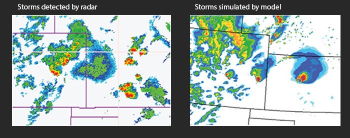
This example from the evening of May 5, 2007, shows how even high-resolution models such as the NCAR-based ARW-WRF cannot yet predict exactly where and when thunderstorms will form. At left is a radar composite image that shows where showers and thunderstorms were occurring at 10:00 p.m. CDT on May 5. One of the intense storms in southwest Kansas produced a deadly tornado that destroyed some 95% of the town of Greensburg, Kansas. On the right is a 24-hour forecast generated by ARW-WRF, valid at 7:00 p.m. CDT on May 5. Although the model correctly depicted thunderstorms in Colorado and Kansas, it forecast a single powerful storm in northern Kansas instead of the multiple storms that struck southern Kansas. (Graphic courtesy MPEX.)
Advanced forecast models can now simulate the weather at points packed as closely as about a half-mile from each other. This allows showers and thunderstorms (known as “convection”) to be explicitly depicted. But these experimental models, as well as the current models used for operational weather prediction, still struggle at times to map out storm behavior, especially beyond about six hours in advance.
Scientists believe this may be largely because the models need more detail on upper-level features, such as pockets of strong wind or dry air, located several miles above ground level. As these features move into the Great Plains, they can be critical for triggering or suppressing severe storms. However, weather satellites may not see these features, and they often go undetected by limited surface and upper-air networks across the Rocky Mountain states.
“The structure of the atmosphere two to six miles above sea level is incredibly important,” Weisman says. “This appears to be where the biggest forecast errors develop, so we need to collect more data at these heights.”

MPEX will include early morning flights with the NSF/NCAR Gulfstream V aircraft (also known as HIAPER, the High-performance Instrumented Airborne Platform for Environmental Research). (©UCAR. Photo by Carlye Calvin. This image is freely available for media & nonprofit use.) See video of the Gulfstream V in flight, below.
To get around the data roadblock, MPEX will send the Gulfstream V aircraft from its base at the Rocky Mountain Metropolitan Airport in Broomfield on missions that will start as early as 3:00 a.m. The aircraft will sample jet-stream winds, upper-level temperatures, and other features across Colorado and nearby states.
The aircraft will use a microwave-based temperature sensor to profile horizontal temperature contrasts miles above the region. At pre-specified locations, it will also deploy parachute-borne minisondes—compact instrument packages, similar to but smaller than the 200-plus radiosondes used every day across the nation—to gather extra detail between flight level and ground level. The minisondes will provide information on temperature, moisture, and winds four times each second.
“The Gulfstream V is perfect for this kind of study,” says NCAR project manager Pavel Romashkin, who will oversee MPEX aircraft operations. “The aircraft is one of a very few in weather research that can sample the atmosphere near the top of important features for a number of hours.”
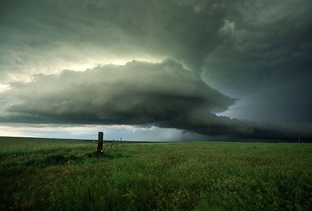
Findings from MPEX could lead to more specific forecasts of thunderstorms with 6 to 24 hours of lead time. (©UCAR. Photo by Bob Henson. This image is freely available for media & nonprofit use.)
MPEX will also gather data with three radiosonde launch units operated by Purdue, CSU, and NSSL in vehicles that will maneuver around late-day thunderstorms. The goal is to find out how well the extra data can help predict local and regional weather conditions into the next day, as well as to assess how the thunderstorms interact with the atmosphere that surrounds and supports them.
“We know that even isolated, short-lived thunderstorms influence their environment,” says Robert “Jeff” Trapp of Purdue, an MPEX principal investigator. “The MPEX data will allow us to quantify these influences and examine how well they are represented in computer forecast models. This information will then be used to help improve weather forecasts."
With the help of improvements in computing power and scientific understanding, forecast models can depict weather in far more detail than just a few years ago. On each day of operations (about 15 in all during the project), MPEX will produce an ensemble of up to 30 forecasts using the NCAR-based research version of the multiagency Weather Research and Forecasting model (WRF-ARW).
Along with data from the Gulfstream V flights, each WRF-ARW ensemble member will use a slightly different characterization of early-morning weather conditions in order to allow for the uncertainty inherent in those measurements. Forecasters can then issue forecasts with greater or lesser confidence based on how the ensemble forecasts agree or disagree.
The MPEX team will also evaluate how much the data from research flights improves forecasts in two other modeling systems, both of which are updated each hour.
The complex process of incorporating observed data into the MPEX simulations will be handled by NCAR’s Data Assimilation Research Testbed. Studies at NCAR and elsewhere have shown that major forecast improvements are possible when the right kinds of data are collected and assimilated into forecast models. Scientists hope the results from MPEX will help advance this process, which could improve predictions of severe thunderstorms as well as other types of high-impact weather where better forecasts in the 6- to 24-hour period could help people and communities better prepare.
HIAPER in action, when it first came into service and during prior field campaigns
![]()
View this playlist on YouTube. (©UCAR. These videos are freely available for media & nonprofit use.)