A terrible tornado
The El Reno EF5 shocks researchers and the public
Jun 7, 2013 - by Staff
Temporary impacts to NSF NCAR Road, Parking Lot and Trails
View more information.Jun 7, 2013 - by Staff
Bob Henson • June 7, 2013 | The world of severe storm science has been shaken over the last week by the deaths of three longtime researchers in a vicious tornado on May 31 near El Reno, Oklahoma. The event also raised serious questions about how residents of large metropolitan areas can best respond to tornado threats.
Tim Samaras, Paul Samaras, and Carl Young were among several people killed by the May 31 tornado. The three had gained public attention through appearances on the Discovery Channel’s “Storm Chasers” series. They had also earned respect and credibility within the science community for their exacting measurements of conditions in and near tornadoes.
Among Tim Samaras’ landmark observations was the largest and most rapid pressure drop ever measured on Earth: roughly 100 mb (about 3.00” inches of mercury on a home barometer) in the span of five seconds in an EF4 tornado that virtually destroyed the town of Manchester, South Dakota, on June 24, 2003.
A blog post by atmospheric scientist Roger Edwards cites the contributions made by Tim Samaras and his team to the peer-reviewed literature.
Even by the standards of Earth’s most violent tornadoes, the El Reno event stands out. It was sampled from only a few miles away by the high-speed RaXpol mobile Doppler radar, operated by the University of Oklahoma. RaXpol detected near-surface winds as strong as 295 mph. (The threshold for an EF5 rating, the highest on the Enhanced Fujita Tornado Damage Scale, is a three-second-long wind gust exceeding 200 mph.)
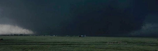
Veteran storm chaser Gene Moore caught this dramatic picture of the May 31 tornado near El Reno, Oklahoma, near the peak of its intensity. The record width of the tornado, together with a low cloud base, resulted in an extreme wedge-shaped appearance. (Photo © Gene Moore.)
Just as impressive as its howling winds was the twister’s vast size and rapid evolution. It grew within a single minute from a width of about 1 mile to roughly 2.6 miles, making it the widest tornado ever measured. And while many tornadoes veer slightly toward the left toward the end of their life cycles—similar to the the occlusion process of huge midlatitude storm systems—the El Reno tornado started out moving toward the southeast, then made an unusually sharp turn to the northeast midway through its life cycle. Violent subvortices spun around the main vortex at speeds of more than 180 mph. All of these factors made this tornado exceptionally dangerous for chasers and residents alike.
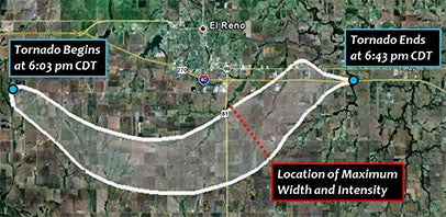
The National Weather Service office in Norman, Oklahoma, found that the EF5 tornado near El Reno on May 31, 2013, had a path length of 16.2 miles, with a maximum width of 2.6 miles—the largest ever measured in any tornado. (Image courtesy NWS.)
How do you assess the true strength of such a rare beast? The enhanced Fujita scale was unveiled in 2007 with a set of 28 “damage indicators,” including various types of buildings. Each of these includes a spectrum of damage that can in turn be correlated with tornadic winds. For example, a strip mall’s degree of damage can be ranked from 1 (the threshold of visible damage) to 9 (complete destruction of all or part of a building).
The El Reno tornado was originally estimated to be an EF3. The twister had passed over a largely rural area, so it had not hit any structures or other damage indicators that could reveal the tornado’s full strength before the RaXPol data were verified.
Mobile Doppler data has played a key role in raising the EF estimates of other recent tornadoes, including another EF5 twister that struck near El Reno on May 24, 2011. The consensus document that guided creation of the enhanced Fujita scale (see PDF) gives the green light to use radar data in this way. It states: “The technology of portable Doppler radar should also be a part of the EF Scale process, either as a direct measurement, when available, or as a means of validating the wind speeds estimated by the experts.”
Of course, countless tornadoes plowed their way through the Great Plains before the advent of basic anemometers, much less sophisticated Doppler radar. It’s impossible to know which tornadoes prior to recent years might be underestimated in strength or width based on inadequate measurement tools.
The El Reno storm bore down on Oklahoma City only 11 days after the suburb of Moore was ravaged by an EF5 tornado, one that damaged or destroyed more than 10,000 structures and killed two dozen people. Residents of central Oklahoma, with memories so fresh and the damage so close at hand, thus faced what some researchers call the shadow effect—when a recent trauma shapes how one responds to a current threat.
While an EF5 tornado can level a one-story home down to its foundation, that rating is based on the most intense pockets of damage. Thus, many areas even in the direct path are not likely to see EF5-level destruction. With this in mind, severe storm experts typically counsel people to shelter in place. As stated by Harold Brooks (National Severe Storms Laboratory) in a recent blog post: “Get as low as you can and put as many walls as you can between you and the tornado.”
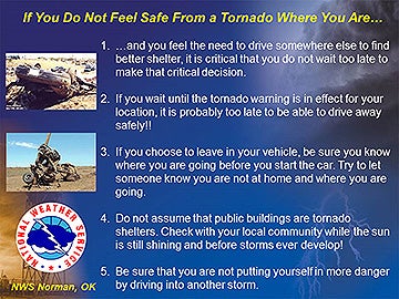
This graphic was posted on the Facebook page of the National Weather Service forecast office in Norman, Oklahoma, about 2:00 p.m. on May 31, several hours before tornadic storms developed. (Image courtesy NWS.)
Nevertheless, many people hop into their cars as a strategy for reducing their tornado risk. This NPR story highlights the conflicts at play.
Recognizing that self-evacuation is not uncommon, the National Weather Service office in Norman posted the image at right on its Facebook page several hours before the May 31 storms developed. The idea is that, if people feel inclined to flee toward a safer location, they should do so well before a tornadic storm actually approaches. "We do not encourage people to run away from a tornado in their vehicle," said the office in its post, "but if you feel that's what you need to do, here are some guidelines."
In contrast, one Oklahoma City weathercaster advised people to “drive south,” away from the city core, just as the El Reno storm was moving into the metro area. A massive traffic jam developed, with thousands of vehicles trapped on interstate highways as the tornadic storm moved in and flooding soon followed. As it turns out, the flash floods—triggered as the tornado’s parent thunderstorm dumped up to eight inches of rain in places—may have caused more of the storm’s 20 reported fatalities to date than the tornado did.
On interstate highways, tornado deaths are actually fairly rare—only 9 were recorded between 1990 and 2008 in the central United States, according to a 2010 analysis. However, the outcome on May 31 could have been far worse, had a tornado made a direct hit on a major Oklahoma City interstate. With any luck, this near-miss will prompt research in communication and risk perception that helps minimize the odds of a true disaster the next time a strong tornado and a metropolitan area mix it up.
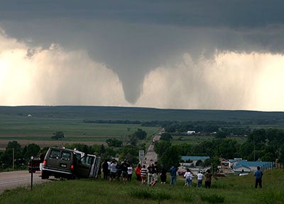
Chase groups operated by tour companies or universities are a common sight in and near tornadoes, as was the case near La Grange, Wyoming, on June 5, 2009, as a tornado developed a few miles to the west. This twister was also exhaustively sampled by research-based chase crews for the VORTEX2 project, the the second field phase of the Verification of the Origins of Rotation in Tornadoes Experiment. Former NCAR director Roger Wakimoto and colleagues have published several analyses of the tornado, including this 2012 paper for the journal Monthly Weather Review. (Digital Image Library photo © UCAR.)
“Much of the social science research on tornadoes is conducted after the event,” says NCAR expert Julie Demuth. “Although such studies are informative, they don’t always help us understand what people were thinking or perceiving and how that connects to why they did what they did.”
Demuth sees the need for more studies that explore how people develop perceptions and beliefs about tornado risk, including their past experience with hazards, and how those beliefs shape how people respond. “Then we can use this knowledge to help create and disseminate messages that will enhance how people make decisions and reduce their risk.”
Along with the three researchers lost to the storm, a layperson reported to be an occasional tornado chaser was also killed in the El Reno twister of May 31. Several other storm chasers had extremely close calls, with a Weather Channel vehicle tossed into a field and a veteran chaser nearly drowned.
Even before the chaser deaths came to light, Jason Samenow at Capital Weather Gang dubbed the El Reno event "the day that should change tornado actions and storm chasing forever." Several faculty from meteorology departments in the UCAR university community have also weighed in on the event and its implications.
Over the last several weeks, the NCAR-led Mesoscale Predictability Experiment (MPEX) has brought several mobile units deploying radiosondes (balloon-borne instrument packages) into the environment around severe storms. The MPEX teams launched sondes into the atmosphere feeding into the central Oklahoma storms of both May 20 and May 31. The MPEX mission to document the environment around thunderstorms has kept its crews well away from the most dangerous parts of tornadic storms.

Click here or on the image to view an animation summarizing the MPEX mobile upsonde operations on May 20 in central Oklahoma. Each frame of the animation shows the KTLX (Oklahoma City area) radar at the approximate time of upsonde launches, with magenta dots showing launch locations. MPEX researchers surrounded the large supercell to the south of the OKC/Moore tornadic supercell (seen in a few frames, north of the MPEX locations.) (Image courtesy MPEX Field Catalog, NCAR Earth Observing Laboratory.)