Spring snow goes downhill
Earlier melting a threat to water supply, Arctic ice
Mar 21, 2014 - by Staff
Mar 21, 2014 - by Staff
Bob Henson • March 27, 2014 | At some point in a typical winter, almost half of the entire Northern Hemisphere’s land area is plastered with snow cover. You’d expect that snow to disappear in the spring, and, even after this unforgiving U.S. winter, most of it will. However, in recent years, spring snow has been vanishing even more quickly than computer models and climate scientists had expected.

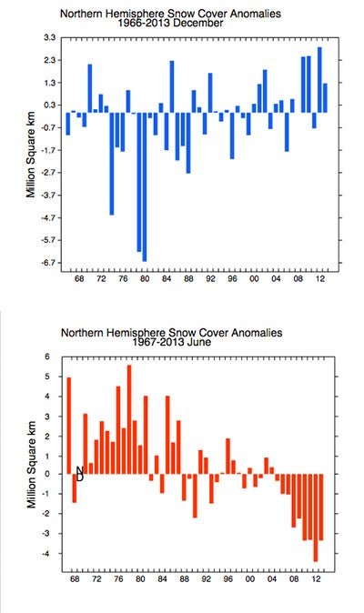
Snow extent across the Northern Hemisphere has increased since the 1980s in December, but decreased by an even larger margin in June. (December and June images courtesy Rutgers University Global Snow Lab.)
This decline in spring snow cover has gotten less public attention than the well-documented decrease in Arctic sea ice. In its own way, though, it’s every bit as impressive and problematic— posing a research challenge and a potentially serious risk for farmers and other heavy users of water supplies.
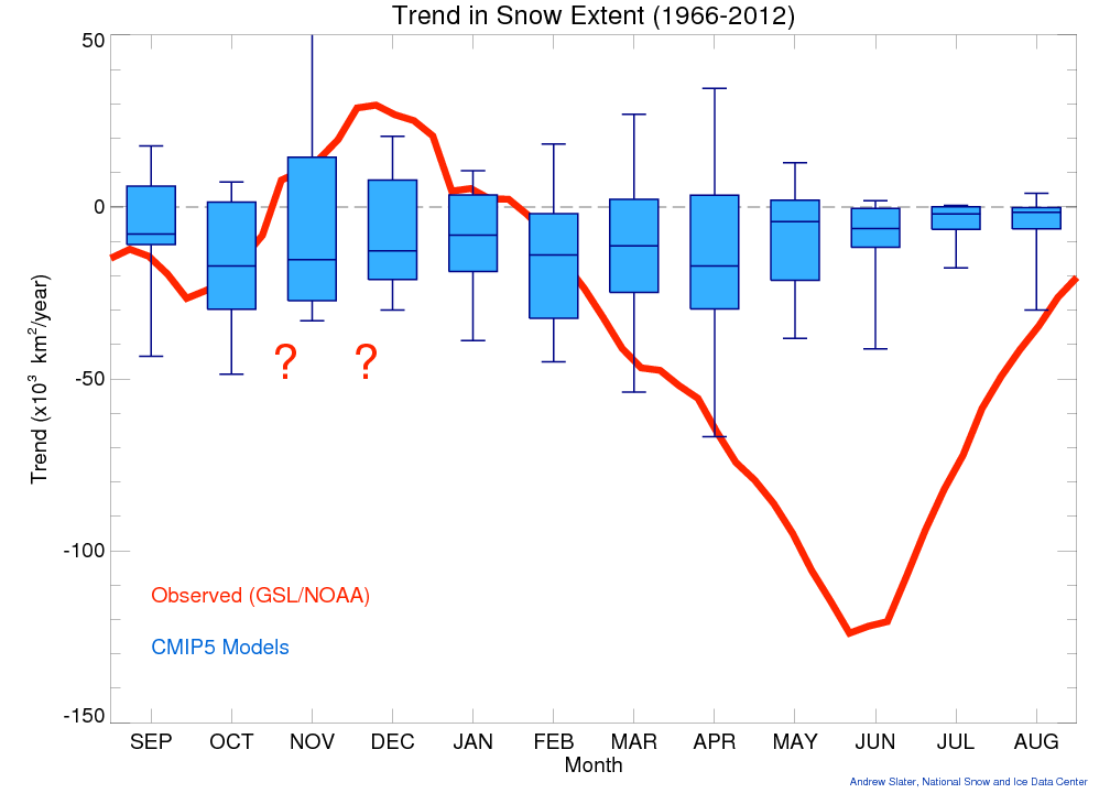
The story isn’t all about decline. Intriguingly, the amount of northern snow cover has actually grown slightly in November, December, and January during the 46 years of satellite data (see graphic below).
However, the only monthly changes that are statistically significant are the decreases from March to June, according to the 2013 assessment by the Intergovernmental Panel on Climate Change. (See Table 4.7, p. 358, of this PDF).
The IPCC attributes this spring loss mainly to higher temperatures, rather than to any major reduction in snowfall itself.
Now that spring is upon us, we’re entering the time of year when the long-term change in northern snow cover is most pronounced, especially in May and June. By that point, snow over northern land is mostly limited to parts of Canada, Russia, Greenland, and the high mountain ranges of western North America and Eurasia. However, this still represents a lot of snow-covered territory. In some years during the 1990s and early 2000s, there was enough northern snow remaining in June to cover an area the size of all 50 United States (about 3.8 million square miles, or about 9.8 million square kilometers).
Those days are long gone. Snow cover during June in the Northern Hemisphere has fallen far below the long-term average every year since 2008, with the coverage dipping to as little as 2 million sq mi/4.9 million sq km in 2012. The rate of decline averaged about 17% per decade from 1979 to 2013, according to research led by Chris Derksen (Environment Canada).

Over the last 45 years, the amount of Northern Hemisphere land covered by snow has increased slightly in late autumn but decreased dramatically from late winter into early summer (red line shows simple linear trend in snow extent). The decrease is considerably muted in a subset of the latest round of coordinated global climate modeling (15 CMIP5 models, with "whiskers" showing full range and boxes spanning the middle 50 percent of the range). The red question marks indicate uncertainty in the observed autumn trends, possibly due to changes in methodology and satellite resolution over time. (Image courtesy Drew Slater, National Snow and Ice Data Center.)
One important thing about this late-spring loss of northern snow is that it occurs just when the intensity of sunlight at northern latitudes is approaching its peak. Given that snow cover is highly reflective, the presence of snow in June at a given northern latitude has a much larger climate-cooling effect than that same snow would have in January.
A 2011 study led by Mark Flanner (University of Michigan) found that, in the period from 1979 to 2008, the loss of Northern Hemisphere snow cover had roughly as strong an influence on Earth’s radiative balance (i.e., on warming the planet) as did the loss of Arctic sea ice.
In short, the less snow cover there is on Earth in late spring, the better chance there is for strong sunlight to warm the planet, rather than being reflected back to space. All else being equal, this means a warmer planet.
The increasing pace of spring snow melt has other implications for climate and society. Here are just two examples:
Scientists at NCAR are among the specialists working to improve the way snow is depicted in climate models. That should help the models do a better job of simulating the seasonal trends already emerging in snow cover.
David Lawrence, who focuses on high-latitude climate, is part of a team that’s recently upgraded the representation of snow cover in the land component of the NCAR-based Community Earth System Model, which is sponsored by the National Science Foundation and the U.S. Department of Energy. The challenge, says Lawrence, is to represent the variegated state of a melting snowpack within a model where a single grid cell can cover thousands of square miles with diverse topography and vegetation.
Even if snow is deposited fairly uniformly across a grid cell, a few days of melting can leave some areas with little or no snow cover and others with much more. The fraction of land still covered by snow is what matters most in reflecting sunlight.
“It’s nontrivial to model this,” says Lawrence. To come up with a representative fraction of snow-covered land for each grid cell, he and colleagues must track a wide array of variables. For example, Lawrence is working with Michigan’s Mark Flanner on how snow intercepted by tree branches affects surface albedo (reflectivity). This involves modeling how long snow stays on trees after a storm, which is a function of wind, temperature, and tree species.

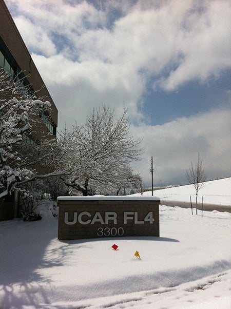
A blanket of spring snow draped the NCAR/UCP/UCAR Foothills Lab complex on April 23, 2013. The storm dumped more than 7 inches on Boulder, helping lead to the city's snowiest April on record, with 47.6" observed for the month. For the western United States as a whole, spring snow cover is on the decrease. (Photo by Bob Henson, ©UCAR.)
On the regional scale, the NCAR-led Colorado Headwaters Project is a multiyear study using detailed simulations to map the fate of western U.S. water in the 21st century. Recent high-resolution output suggests that precipitation may actually increase in Colorado’s high country during wintertime, but decrease in summertime. The group is now looking more closely at how an earlier “meltout” of high-country snow will affect the picture.
"As shifts in the timing of meltout occur, we lose an important and relatively stable snowpack reservoir,” says NCAR’s David Gochis. “This affects a variety of other hydrologic processes, such as the amount of water in streams and how much is left in local water tables at the end of the summer.”
How well do models reproduce what’s been happening, regionally and globally? On the global scale, climate models have tended to downplay these trends (see graphic). But across the western United States, model experiments carried out by Gochis and his group confirm the picture of somewhat more snow cover in early winter and a good bit less in springtime.
“We are now doing a much larger set of runs that extend well into Canada, with a timeframe from 2000 to 2013,” says Gochis. “We'll be sure to look for the signal in those runs, too.”