El Niño’s high-altitude highway
Weather shaper affects Europe via the stratosphere
May 14, 2014 - by Staff
Temporary impacts to NSF NCAR Road, Parking Lot and Trails
View more information.May 14, 2014 - by Staff
May 14, 2014 | Researchers and forecasters have long known that El Niño can influence weather thousands of miles away. It now appears that this Pacific Ocean phenomenon exerts its global impact through two different atmospheric pathways, one located miles above the other. Scientists are now mapping out these routes, which will help bolster prediction of regional climate.
When an El Niño event arrives every few years, it shifts the location of warm sea-surface temperatures and persistent showers and thunderstorms eastward across the tropical Pacific Ocean. The rising air forces rearrangements nearby, and the signals reverberate outward through the troposphere (the lowest few miles of the atmosphere). Depending on location, this shifts the seasonal odds toward warm, cool, wet, or dry in many parts of the Americas, Asia, and Australia. The status of the El Niño–Southern Oscillation (ENSO) is one of the main tools used by U.S. seasonal forecasters in looking ahead to what a given winter might bring.
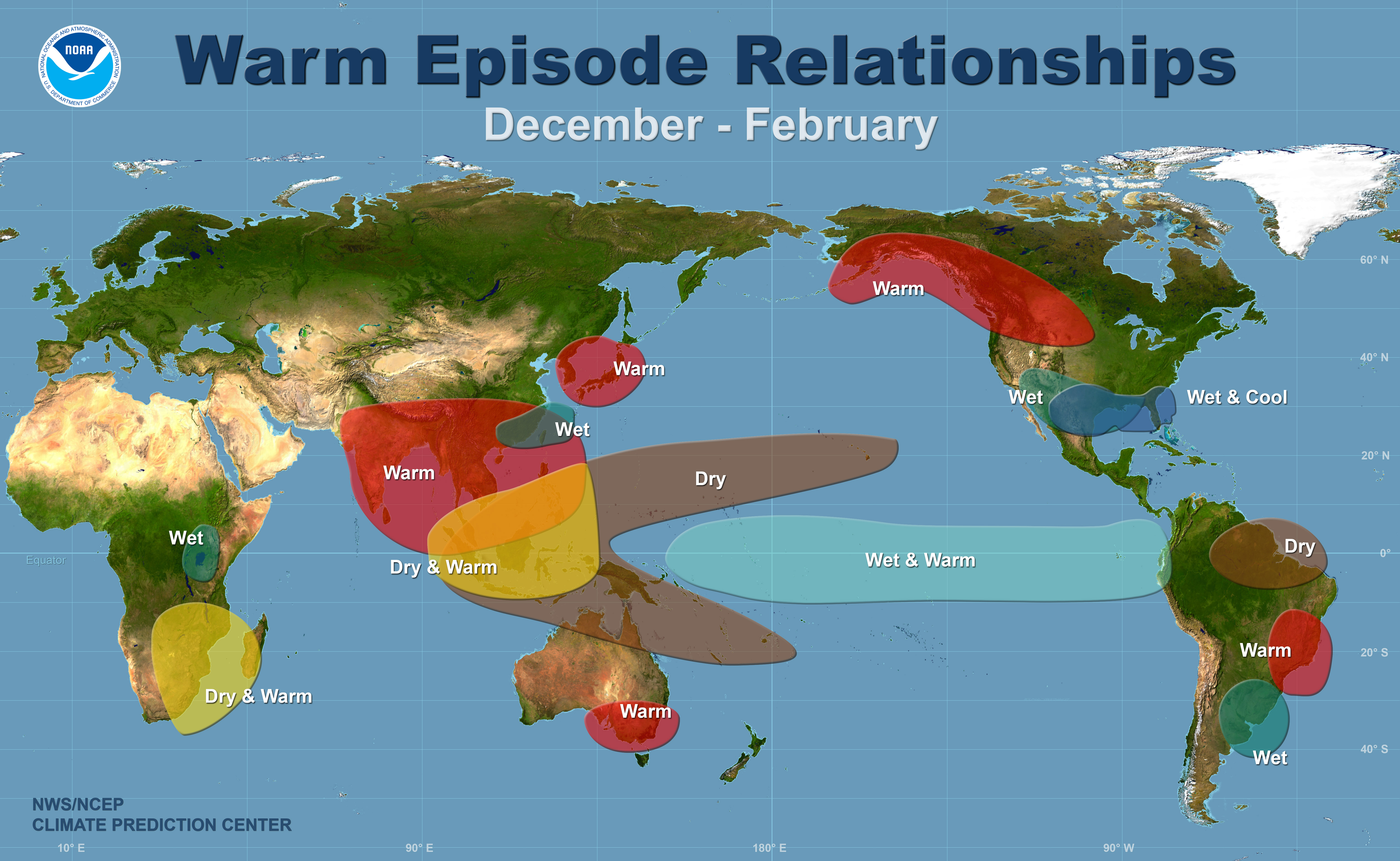
El Niño's typical impacts (December–February) are well known for much of the globe, as shown above. Scientists are now finding that Europe and Asia are also affected by El Niño, through an increased likelihood of sudden warmings in the stratosphere that influence seasonal climate. (Image courtesy NOAA Climate Prediction Center.)
A study led by Amy Butler (University of Colorado Boulder/CIRES) now shows that El Niño effects extend all the way to Europe, where their influence was long thought to be minimal. Several modeling studies in the last few years have hinted at this potential connection. The new paper, published in Environmental Research Letters, finds clear evidence for the link over the last half-century.
“Ours is the first study to examine the observations and really pull apart how El Niño can bring impacts all the way to the other side of the world,” said NCAR’s Clara Deser, a coauthor on the study along with Lorenzo Polvani (Columbia University). “It’s an interesting story, separating these stratospheric and tropospheric pathways.”
El Niño’s influence on Europe has been obscured in part because it operates with help from a third party: the dramatic wintertime events known as sudden stratospheric warmings (SSWs). Occurring every winter or two on average, an SSW can disrupt and weaken the polar vortex at the jet-stream level, often leading to cold outbreaks in eastern North America and Europe.
The combination of an El Niño event and an SSW appears to be especially conducive to outbreaks of Arctic air. Looking at the period November through March, the scientists found that seasonal temperatures across northern Eurasia plunged more than twice as far below average during an El Nino winter with at least one SSW as compared to an El Nino winter with no SSWs.
Looking at the period 1958–2013, the scientists also found that SSWs were more than twice as likely to occur during El Niño years as during neutral years. “When you focus on those years, the stratospheric pathway emerges with great clarity,” said Butler.
SSWs can’t be predicted more than a few days in advance, and it’s not yet clear exactly how they form and how the influence of El Niño makes their way through the stratosphere. However, the new work suggests that forecasters could use the presence of El Niño to alert people that an SSW’s cold-inducing effects could be stronger than usual in northern Eurasia (and perhaps in eastern North America, although the current study doesn’t examine that problem directly).
According to Deser, “We can’t predict whether the sudden stratospheric warmings are going to occur, but we can say: If they do, this is what to expect.”
|
Writer/contact Lead researchers |
Collaborating institutions Funder |
Butler et al., "Separating the stratospheric and tropospheric pathways of El Niño–Southern Oscillation teleconnections," Environ. Res. Lett. 9 (2014), doi:10.1088/1748-9326/9/2/024014
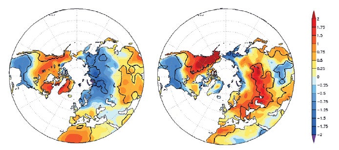
Uncovering ENSO's Eurasian effects. These images show where the collective impact of both El Niño and La Niña is greatest, using departures from average temperature (degrees C) for the period November to March. In both plots, the departures during La Niña winters are subtracted from those during El Niño winters to highlight areas where the effects are in opposite directions. The left plot is for winters with at least one sudden stratospheric warming (SSW), while the right plot is for winters with no SSWs. The differences between the left and right panels are most evident across Eurasia. (Image adapated from Figure 3, Butler et al., "Separating the stratospheric and tropospheric pathways of El Niño–Southern Oscillation teleconnections," Environ. Res. Lett. 9 (2014), doi:10.1088/1748-9326/9/2/024014.)