Why do La Niña events linger?
Modeling breakthrough could give prediction a boost
Aug 13, 2014 - by Staff
Temporary impacts to NSF NCAR Road, Parking Lot and Trails
View more information.Aug 13, 2014 - by Staff
August 12, 2014 | For millions of people, the onset of El Niño or La Niña in northern autumn indicates whether they’re likely to face unusually warm, cold, wet, or dry conditions over the coming winter. A new modeling study pins down the process that apparently determines why La Niña events often last twice as long as typical El Niño events—a result with major implications for seasonal predictions extending more than a year out.
“Our work suggests that we can make significant progress on predicting La Niña events and determining how long they might last,” said NCAR scientist Clara Deser. “Because of the disproportionate impact of La Niña on drought throughout the world, this could help lead to concrete social benefits.” Deser recently coauthored a paper with Pedro DiNezio (University of Hawaii) that is now in early release in the Journal of Climate.
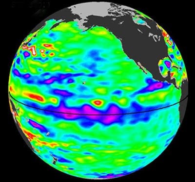
La Niña conditions were in place during the northern winters of 2010–11 and 2011–12, with major drought impacts observed in the United States. This 10-day average of ocean height across the tropical Pacific, collected by the U.S–French Ocean Surface Topography Mission/Jason-2 satellite, spans a period centered on September 3, 2010, when the La Niña event had already reached moderate levels. Lower ocean heights centered on the equator (blue and purple) indicate cooler-than-average conditions there. (Image courtesy NASA.)
Although they’re often portrayed as a pair of opposites, El Niño and La Niña aren’t mirror images of each other. El Niño events—which involve warmer-than-usual water overspreading the eastern tropical Pacific—tend to last no longer than one year. However, in recent decades, almost half of La Niña events—which lead to strong trade winds and cooler-than-usual surface water—have returned for a second consecutive northern winter. This was the case during 2010–11 and 2011–12, two La Niña years that were both associated with devastating U.S. droughts.
DiNezio and Deser examined the duration of La Niña in climate simulations performed with the Community Climate System Model (CCSM4). Computer models have long struggled to realistically simulate El Niño and La Niña, but CCSM4 is one of a small number of newer models in which El Niño and La Niña events are produced at a realistic pace and strength, making it suitable for the new research.
Longstanding theories predict that the stronger trade winds associated with La Niña kick off very slow-moving ocean waves that move westward across the Pacific, bounce off the coast, and then, a year later, return to the central Pacific. These waves depress the thermocline—the boundary between frigid deep waters and warmer surface waters—by several dozen feet, which allows the ocean surface to warm and effectively ends La Niña.
The team scrutinized this mechanism in 252 La Niña events produced by the CCSM4 in a simulation of 1,300 years of climate. In one out of every three simulated La Niña events, the waves did not succeed in ending the event, and La Niña persisted into a second year.
As La Niña becomes stronger, the magnitude of this effect does not increase proportionally—a result observed in the model as well as in observations. This disproportionate, nonlinear behavior occurs because as the thermocline deepens, the resulting warming effect on surface waters reaches a limit. Thus, the depressed thermocline may need to persist for a second year in order to bring a strong La Niña event to an end.
This result has implications for predicting two-year La Niña events. Notably, the team found that the depth of the thermocline six months before a La Niña begins was correlated with sea-surface temperature anomalies a year and a half later. “This could provide an 18-month lead time for predicting the return of La Niña conditions for a second year,” said Deser.
Pedro N. DiNezio and Clara Deser, Nonlinear controls on the persistence of La Niña, Journal of Climate (2014), doi:http://dx.doi.org/10.1175/JCLI-D-14-00033.1
Writer/contact
Bob Henson, NCAR/UCAR Communications
Collaborating institutions
NCAR
International Pacific Research Center, University of Hawaii
Funders
Japan Agency for Marine-Earth Science and Technology
NASA
National Oceanic and Atmospheric Administration
National Science Foundation
University of Hawaii
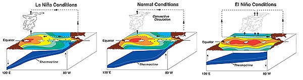
La Niña (left), neutral or "normal" conditions (middle), and El Niño (right) each have a distinctive signature of oceanic and atmospheric processes, as seen in this cross section of the tropical Pacific Ocean extending from Australia and Indonesia (left side of each panel) to the Americas (right side of each panel). Warm sea surface temperatures (reds and oranges) are shunted to the west during an El Niño event but extend eastward during a La Niña event. These warmer surface waters tend to be collocated with showers and thunderstorms and a deeper thermocline, the oceanic boundary separating warmer surface waters from colder, deeper waters. New research relates the depth of the thermocline in the central Pacific to the duration of a subsequent La Niña event. (Diagrams courtesy NOAA Pacific Marine Environment Laboratory.)