Using GPS to improve tropical cyclone forecasts
COSMIC microsatellites help predictions of cyclone track and intensity
Aug 20, 2014 - by Staff
Temporary impacts to NSF NCAR Road, Parking Lot and Trails
View more information.Aug 20, 2014 - by Staff
August 20, 2014 | One of the challenges in forecasting tropical cyclones is that measuring atmospheric conditions over the open ocean is extremely difficult. New research indicates that the COSMIC microsatellite system, which uses a technology known as GPS radio occultation to observe remote regions of the atmosphere, can significantly improve predictions of tropical cyclones.
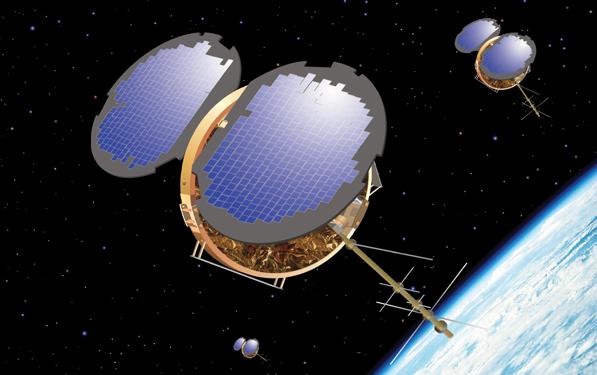
By using GPS signals to monitor the atmosphere in three dimensions, the FORMOSAT-3/COSMIC satellite constellation has led to improved global weather monitoring, especially in data-sparse regions. (Image courtesy UCP/COSMIC.)
Forecasts traditionally draw on observations taken by instruments on Earth’s surface or by radiosondes, which are lifted into the atmosphere by balloons. But both these approaches are limited in hard-to-access places, like the open ocean. In contrast, GPS radio occultation measurements can be made almost anywhere, and they are unaffected by clouds, light rain, or airborne aerosols.
To apply this promising technology, the United States and Taiwan launched the COSMIC system in 2006 with six microsatellites. The system—formally known as the Formosa Satellite Mission 3 (FORMOSAT-3) Constellation Observing System for Meteorology, Ionosphere, and Climate (COSMIC)—has provided about 1,500 radio occultation soundings per day for research and weather forecasting. The two countries plan to launch an additional six COSMIC satellites in 2016 and another six in 2018, which will give forecasters and researchers far more data.
The UCAR COSMIC office helps oversee the system and manages the data collected by the microsatellites.
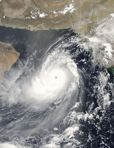
On June 4, 2007, when the Moderate Resolution Imaging Spectroradiometer (MODIS) on NASA’s Aqua satellite captured this image, Cyclone Gonu was approaching the northeastern shore of Oman, a region better known for hot desert conditions. Though rare, cyclones like Gonu are not unheard of in the northern Indian Ocean basin. (Image courtesy MODIS Rapid Response Team, NASA.)
In the new study, researchers compared COSMIC measurements of the atmosphere with those taken by balloon- and ground-based instruments in 2007 during Super Cyclonic Storm Gonu, the strongest cyclone recorded in the Arabian Sea. Their goal was to evaluate how GPS RO data contribute to storm modeling and predictions.
“From previous studies, we already knew that GPS RO produces positive impacts on storm modeling, but we didn’t know how,” said Shu-Ya Chen, an atmospheric scientist in UCAR’s COSMIC office.
Chen and her two co-authors ran two sets of weather forecasting models to simulate the formation of Cyclone Gonu over the Arabian Sea and its later track over Oman and Iran. One set included COSMIC measurements along with those from balloon- and ground-based instruments. The other set omitted COSMIC measurements.
They found that the forecast models with the COSMIC measurements simulated the cyclone’s track more accurately. COSMIC estimates of temperature in the upper troposphere and moisture in the lower troposphere were particularly important to improving predictions of the cyclone’s track. The precision of the GPS radio occultation measurements also helped four-day storm track and intensity models.
Anisetty, Prasad Rao; Huang, Ching-Yuang; and Chen, Shu-Ya (2014), Impact of FORMOSAT-3/COSMIC radio occultation data on the prediction of super cyclone Gonu (2007): A case study, Natural Hazards, doi:10.1007/s11069-013-0870-0
Editor/contact
David Hosansky, NCAR/UCAR Communications
Collaborating institution
National Central University, Taiwan
Funders
National Science Council, Taiwan
National Space Organization, Taiwan