Advanced computer model focuses on Hurricane Matthew
Scientists test MPAS on powerful storm
Oct 6, 2016 - by Staff
Temporary impacts to NSF NCAR Road, Parking Lot and Trails
View more information.Oct 6, 2016 - by Staff
Oct. 6, 2016 | As Hurricane Matthew churns toward the southeastern U.S. coast, scientists at the National Center for Atmospheric Research (NCAR) are testing an advanced research computer model to see how well it can predict the powerful storm's track and intensity.
The Model for Prediction Across Scales (MPAS) uses an innovative software approach that allows scientists to focus on regional conditions while still capturing far-flung atmospheric processes that can influence the storm in question. This is a contrast to the forecast models typically used to track hurricanes today, which cannot simultaneously capture both global and local atmospheric processes.
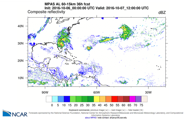 The experimental MPAS model simulates Hurricane Matthew hitting the Southeast. To see a range of model output, visit the MPAS tropical cyclone website.
MPAS is able to do both because it uses a flexible mesh that allows it to zoom into higher resolution in some areas — over hurricane breeding grounds, for example — while zooming out over the rest of Earth. This ability to vary resolution across the globe requires a small fraction of the computer power needed to have high resolution everywhere.
By testing MPAS during hurricane season, the research team can determine the adjustments that need to be made to the model while gaining insights into how to improve hurricane forecasting in the future.
"This is an experimental effort," said Chris Davis, a senior scientist and director of NCAR's Mesoscale and Microscale Meteorology Laboratory. "We're doing this to see if we can find systematic biases in the model so we can improve simulations of the tropics in general and hurricanes in particular."
Davis and the other members of the research team, including NCAR scientists David Ahijevych, Sang-Hun Park, Bill Skamarock, and Wei Wang, are running MPAS once a day on NCAR's Yellowstone supercomputer, inputting various ocean and atmospheric conditions to see how it performs. The work is supported by the National Science Foundation and the Korea Institute of Science and Technology Information.
Even though they are just tests, Davis said the MPAS simulations are often comparable with official forecast models such as those run by the National Hurricane Center and the European Centre for Medium-Range Weather Forecasts. As Matthew was in its early stages, in fact, MPAS did a better job than other models in simulating the northward movement of the storm from the Caribbean Sea toward the Florida coast.
The scientists will analyze how MPAS performed and share the results with colleagues in the meteorological community. It's a step in an ongoing research effort to better predict the formation and behavior of hurricanes.
"We run the model even when the tropics are quiet, but an event like Matthew gives us a special opportunity to see what contributes to errors in tropical cyclone prediction," Davis said. "While a major hurricane can have catastrophic impacts, we hope to learn from it and make computer models even better in the future."
Funders:
National Science Foundation
Korea Institute of Science and Technology Information
Writer/contact:
David Hosansky, Manager of Media Relations