High-end weather modeling, hour by hour
New weather-service system has NCAR roots
Sep 23, 2014 - by Staff
Early closure on July 3 and 4 - NSF NCAR Road, Parking Lot and Trails
View more information.Sep 23, 2014 - by Staff
September 24, 2014 | Founded on an NCAR-based research model, a new weather prediction system will soon be transforming how the National Weather Service (NWS) simulates and predicts short-range weather threats, including severe thunderstorms and blizzards.
Already a success during several years of experimental use, the High-Resolution Rapid Refresh (HRRR) model is currently scheduled for official adoption as an NWS operational model on September 30. Developed by scientists at the NOAA Earth System Research Laboratory, the HRRR utilizes a special version of an NCAR-based atmospheric prediction model called WRF-ARW (see Birth of a Model, below).
The HRRR will be the first model in the NWS operational suite to include hourly updates as well as a resolution sharp enough to simulate individual thunderstorms, with grid points 3 kilometers (about 2 miles) apart.
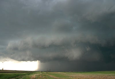
A severe thunderstorm looms just east of Denver on May 21, 2014. The storm's heavy hail and high winds forced closure of the nearby Denver International Airport. Severe thunderstorms during May 20–22 resulted in more than $100 million in insurance claims across Colorado, largely related to hail damage. The new High-Resolution Rapid Refresh (HRRR) model will provide more detailed and accurate forecasts of thunderstorm evolution up to 15 hours in advance. (Photo by Bob Henson, UCAR.)
Much of the uncertainty in current weather forecasts lies in the particulars of showers and thunderstorms—known as convection—which can influence how quickly heavy rain changes to heavy snow or which parts of a state get plastered with a flood-producing downpour.
Each HRRR update will incorporate radar data from the preceding hour, and each update will extend out 15 hours. The result for NWS forecasters will be improved guidance on how thunderstorms are likely to evolve both locally and across the nation.
“HRRR will be updated hourly at storm scale, which is what’s needed for predicting fast-changing storms and something not done before by the NWS,” said Stan Benjamin, head of the Assimilation and Modeling Branch in the Global Systems Division at NOAA’s Earth System Research Laboratory.
Meteorologists who also serve as model software developers in Benjamin’s group led the development of HRRR, including significant additional improvements to the original NCAR-based community model. They worked with colleagues from NCAR and other institutions, including NOAA’s university-based cooperative institutes in Colorado. The model was then tested rigorously by the NWS to ensure that its performance was reliable across a wide variety of weather conditions.
“It’s been a great community effort, of which NCAR has been a huge part,” said Benjamin.
The seeds of HRRR lie in a multiagency initiative called the Weather Research and Forecasting (WRF) model and a research-oriented, NCAR-based version of that model called Advanced Research WRF, or ARW. During more than a decade, over 27,000 registered users have applied ARW, which is available free of charge, to a variety of forecast problems in both research and operational settings in more than 150 countries.
ARW’s versatility and open access have made it a favorite among model developers across the weather enterprise. For example, many viewers of TV weathercasts have seen output from the Rapid Precision Model, a variation of ARW created by WSI Corporation for use in broadcast meteorology and other specialized applications.
To develop the HRRR, researchers in Benjamin’s group linked their refined version of the ARW model with a specially configured system for assimilating data (bringing radar, satellite, aircraft, and other observations into the early stages of a model run to start it correctly with current conditions).
Because of its role as the government’s primary weather agency and the accompanying need for its systems to be extremely reliable, the NWS has produced most of its models in house, allowing it to monitor the entire process. NCAR’s years of experience in providing support for ARW provided a strong signal that the development of HRRR within NOAA would ultimately be successful. Since its NCAR inception, ARW has been refined and improved through carefully checked contributions from various laboratories and universities, including those from NOAA for the HRRR model.
“We’ve been conducting real-time forecast runs with a grid resolution of 3 to 4 kilometers since 2003,” said NCAR’s Wei Wang, who manages user support for ARW. “Our experience with real-time runs demonstrated the capability of this model, which can give people confidence when they decide to build operational systems based on WRF-ARW.”
HRRR is noteworthy for offering the potential to foresee extremely rare events. This is because it can explicitly depict showers and thunderstorms that are not captured by lower-resolution models. “Models like HRRR increase our awareness of what could happen,” said NCAR’s Morris Weisman, a severe storm researcher.
One of the standout achievements during the HRRR development period was its accurate depiction of the devastating derecho that wreaked more than $2 billion in damage from Indiana to Delaware on June 29, 2012. Several runs of the ARW and HRRR correctly predicted that an area of convection over northern Illinois would intensify as it raced southeastward, leaving a trail of destruction and power outages and striking the Washington, D.C., area some 12 hours later. (See In Graphic Terms, below.)
Forecasters don’t expect HRRR to depict every thunderstorm complex perfectly, that far out. However, the hourly tempo of updates will serve as a useful crosscheck. When several consecutive runs of HRRR depict that a major weather event is likely on the way, that will boost confidence; when the runs disagree, forecasters can hold back.
Writer/contact
Bob Henson, NCAR/UCAR Communications
Collaborating institutions
Cooperative Institute for Research in Environmental Sciences
Cooperative Institute for Research in the Atmosphere
National Oceanic and Atmospheric Administration
National Center for Atmospheric Research
Funders
NOAA
National Science Foundation (ARW)
The High-Resolution Rapid Refresh (HRRR) model (NOAA Earth System Research Laboratory)
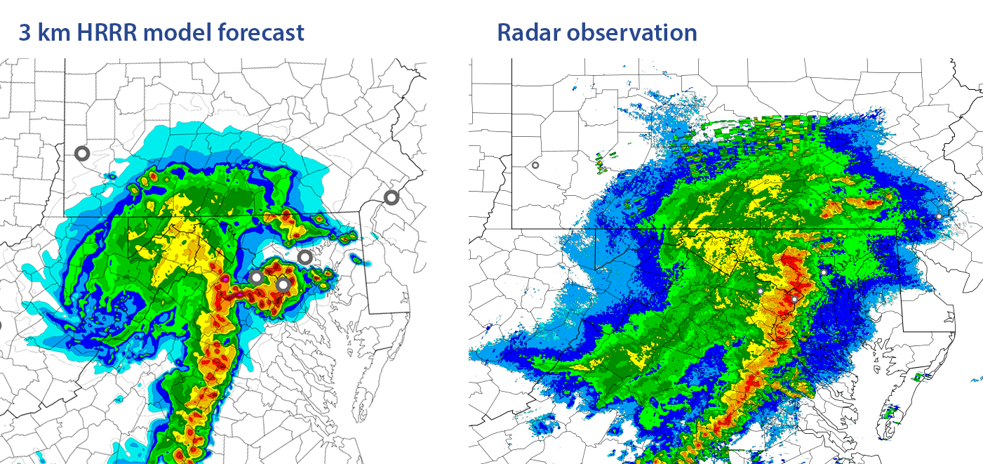
Twelve hours before the Washington, D.C., area experienced severe winds from a derecho, the High-Resolution Rapid Refresh (HRRR) model correctly predicted that a derecho-producing thunderstorm complex would sweep across the area from the west. Left: HRRR forecast, issued at 11 AM EDT on June 29, 2012 and valid at 11 PM EDT. Right: Radar depiction of thunderstorms in the Washington area at 11 PM EDT. More about the event: Derecho in DC - AtmosNews. (Images courtesy Steve Weygandt, NOAA; Curtis Alexander, NOAA/CIRES; and Brian Jamison, NOAA/CIRA.)