Building roads to match tomorrow's weather
Climate scientists, engineers team up on drainage systems for transportation infrastructure
Apr 20, 2017 - by Staff
Temporary impacts to NSF NCAR Road, Parking Lot and Trails
View more information.Apr 20, 2017 - by Staff
April 20, 2017 | When engineers design roads, bridges, and other types of transportation infrastructure, they need to account for local weather patterns. Extreme heat or freeze-thaw cycles can lead to ruts and cracks in roads, and heavy rains can overwhelm inadequate drainage systems, washing out bridges and flooding key transportation corridors.
But how should engineers design new transportation projects, which may last for a half-century, if climate change will greatly alter weather patterns? The extent to which temperatures and precipitation may change in the future has become a major concern for the transportation industry.
To address this issue, climate scientists at the National Center for Atmospheric Research (NCAR) are launching an innovative collaboration with civil and environmental engineers at Carnegie Mellon University and the RAND Corporation. They're using global and regional computer models, along with statistical techniques, to generate projections of future climate in ways that will be most helpful to infrastructure designers and planners, especially when it comes to drainage.
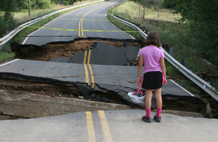 A girl looks at a washed-out road in Louisville, Colorado, after damaging floods in 2013. Engineers are teaming up with climate scientists to design transportation infrastructure that can withstand shifting weather patterns. (Photo by David Hosansky.)
The three-year project, funded by the National Science Foundation, will focus on Pittsburgh and several other cities across the country that will likely be affected in different ways by future climate.
"Our overriding goal is to enable transportation agencies to maximize the lifetime performance of new infrastructure while minimizing the costs to ensure its resilience to extreme weather events," said NCAR senior scientist Linda Mearns, the principal investigator on the project.
Several recent studies led by NCAR scientists have underscored the extent to which climate change may affect future temperature and precipitation extremes in the United States. One concluded that, if emissions of greenhouse gases continue along a business-as-usual course, record daily high temperatures will outpace record daily lows by about 15 to 1 later in the century. A second study, also looking at emissions continuing on a business-as-usual path, concluded that incidents of extreme rainfall may increase by as much as five times in parts of the country.
To conduct the new project, Mearns and her colleagues are working closely with local transportation officials and other stakeholders. Rather than analyzing the overall ways that climate is likely to change in the target cities, they're focusing on information that will be most useful to the design and construction of drainage infrastructure and other transportation systems.
"This requires very active engagement with stakeholders," Mearns said. "It's working together to determine what they want versus what we can actually provide and coming up with measures of uncertainty that are meaningful for them. This is in the realm of true coproduction of knowledge."
For example, an engineer designing a drainage system along a highway might want an estimate of how much precipitation will fall in 15-minute increments. Although climate models do not provide such detailed information, Mearns and her colleagues can provide a partial answer by using a combination of techniques to produce projections of future precipitation every hour to several hours, as well as characterizing the uncertainty around those projections.
A major challenge is that more detailed projections have greater uncertainty. While climate models consistently show that emissions of greenhouse gases lead to higher average global temperatures, the outlook is less clear for temperature and precipitation patterns by region. The type of information most needed by infrastructure planners and designers—projections of extreme temperatures and precipitation for specific locations and time periods—is even more uncertain. As a result, the study team will have to make compromises between the need for high-resolution data and the need for reliable data.
Mearns said it's critical to give engineers a clear understanding of the uncertainty of a particular projection in order to prevent transportation projects from being based on a false sense of precision in climate projections. "The challenge," she said, "is developing sound engineering strategies for extremes under uncertainty."
In addition to Mearns, the NCAR scientists working on the project include Seth McGinnis, Melissa Bukovsky, Rachel McCrary, and Doug Nychka. The Carnegie Mellon team is being led by Costa Samaras, who directs the school's Center for Engineering and Resilience for Climate Adaptation.
“This project is a unique interdisciplinary collaboration that will advance the ways engineers and climate scientists will work together in the future,” said Samaras. “Infrastructure can last for many decades, and engineers need to design infrastructure to be resilient at the end of the infrastructure life span as well as in the beginning. Working with NCAR is critical to advancing the research needed to transform the way we design infrastructure in the United States."
To generate climate projections, Mearns and her colleagues will use two types of techniques to translate the coarse resolution of a global computer model, which typically simulates climate processes that are larger than about 100 miles, into the localized weather events that are of interest to transportation experts.
One of these techniques, known as dynamical downscaling, will use a combination of three coarser-resolution global climate models and two higher-resolution regional models (including the NCAR-based Weather Research and Forecasting model, or WRF). This will enable the researchers to simulate the entire globe in coarse resolution while zooming in on selected regions with much higher resolution. This approach doesn't need as much supercomputing power as trying to simulate the entire globe in high resolution, although it still can be computationally intensive.
The other technique, known as statistical downscaling, involves developing statistical relationships between large-scale atmospheric patterns and local temperatures and precipitation. This technique, which requires even less computing, can help scientists link conditions in a global model (such as a large area of low pressure) to a localized weather event (such as intermittent downpours).
The combined approaches will enable the scientists to generate projections for at least every six hours, and possibly—with the use of additional specialized techniques—as frequently as every hour. Using both the dynamical and statistical approaches also will enable the team to better understand the uncertainties around future climate as well as evaluate the relative strengths of the techniques.
"Transportation systems are critical to the U.S. economy, and they represent some of the largest investments of our tax dollars," Mearns said. "We want to make sure that they'll hold up to a future climate."
Funder
National Science Foundation
Partners
Carnegie Mellon University
RAND Coroporation
Writer/contact
David Hosansky, Manager of Media Relations