Snow gaze
PLOWS scoops up insight on winter storm structure
Jan 15, 2010 - by Staff
Temporary impacts to NSF NCAR Road, Parking Lot and Trails
View more information.Jan 15, 2010 - by Staff
3 December 2009 • The giant comma-shaped storm systems that traverse the Midwest from fall through spring-otherwise known as extratropical cyclones-carry more than a few secrets along their lumbering paths. Radar, lidar, and profiler beams are now slicing through those storms, hunting for small-scale features that normally go unobserved.
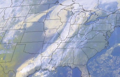 This satellite image from 23 April 2001 shows a classic comma-shaped extratropical cyclone over the U.S. Midwest, with moisture wrapping around the head of the comma across Iowa, Wisconsin, and Minnesota. (Image courtesy NOAA.)
An NSF-funded project called PLOWS (Profiling of Winter Storms) is combining National Weather Service radars and radiosonde launches with a fleet of mobile platforms. Undeterred by rain, snow, ice, darkness, and cold, PLOWS is pushing forward, meeting up with hundreds of undergraduates along the way.
Robert Rauber (University of Illinois at Urbana–Champaign) leads the project, which was inspired by the work of one of his graduate students. Now an NWS forecaster in Milwaukee, Marcia Cronce found herself intrigued by the capabilities of a 915-Mhz wind profiler operated by the University of Alabama in Huntsville. After watching the profiler sample thunderstorms in a 2003 project, Cronce proposed using it to examine convective lines embedded in winter storms. Rauber and UAH's Kevin Knupp took the bait, pooling a few hundred dollars each for gas money.
"What we were trying to do was deduce vertical motion at very high resolution," says Rauber. He and Cronce devised a technique that combined the lowest Doppler frequencies from the profiler with radiosonde data in order to infer upward motion inside storms. (They later learned that the eminent radar meteorologist David Atlas had described a similar approach years earlier.)
The updrafts Cronce analyzed-as strong as 6 meters per second, or about 13 mph-wouldn't strike anyone as intense at ground level, but they're actually quite robust for vertical motions inside a winter storm. Cronce and colleagues published their findings in a 2007 article in the Journal of Applied Meteorology and Climatology, and Rauber went on to develop the larger project that became PLOWS. "We wanted to perform these measurements again with several independent measurement platforms," he says.
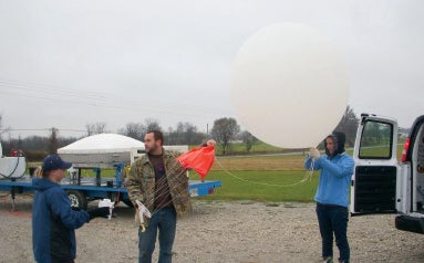 Katie Crandall and Keith Cooley (left, from the University of Missouri) join Melissa Peterson (University of Illinois at Urbana-Champaign) to prepare a radiosonde for launch near Odessa, Missouri, on 14 November. The UAH Mobile Integrated Sounding Platform is in the background. (Photo courtesy PLOWS.)
Snow or no?
The blob-like appearance of many extratropical cyclones on radar and satellite belies their complexity. As moist air wraps around the northern half of the storm (the comma head), drier air feeding into the southern flank may flow above the wrap-around region, creating potential instability. One of the main goals of PLOWS is to map out exactly when, where, and how areas of rain and snow are strengthened as a result.
"We're very interested in the fine-scale structure that hasn't been observed adequately," says Rauber. "We know how the big wrap-around region is created. The big question is what instabilities are present and how they're realized. Hopefully understanding that will help us understand the intense regions where the heaviest snow falls."
Fanning out ahead of each approaching storm are UAH's Mobile Integrated Profiling System (MIPS) and its Mobile Alabama X-band dual polarization radar, as well as mobile sounding systems from NCAR and the University of Missouri. In the air, the NSF/NCAR C-130 is carrying microphysical probes as well as cloud Doppler radar and cloud lidar from the University of Wyoming.
The deployment plan for each storm is constrained by a predetermined set of flight paths from which the C-130 will launch dropsondes, as well as the need to deploy the UAH radar about 30 km (19 mi) from an NWS radar site. Keeping these and other variables in mind, the PLOWS teams choose their targets, deploy, and scan, all while trying to stay warm.
"These conditions present by far the most difficult set-up conditions-cold, dark, windy, wet-that we have ever encountered," says UAH's Knupp, whose group is more accustomed to deploying MIPS in the wet but mild path of a hurricane. In late November, PLOWS gave Stephanie Mullins, a UAH graduate student from New Orleans, her first taste of a raw, chilly Midwestern cyclone (although, mercifully, the temperatures stayed above freezing). The UAH crews bolstered their accessories to fit the season, adding tire and tow chains, snow shovels, heaters, and microwave ovens.
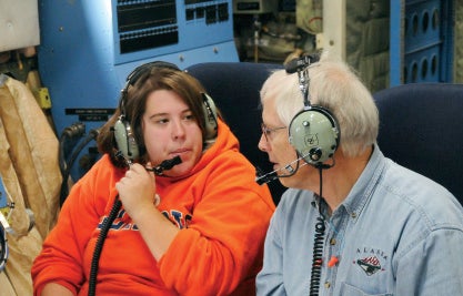 Allison Houghton, a junior at the University of Illinois at Urbana-Champaign, chats with NCAR research scientist David Rogers. (Photo by Larry Oolman.)
During periods of calm weather, the PLOWS fleet is on the road in a different mode, visiting campuses in and around Illinois to give students a taste of fieldwork. Through NSF's Research Experiences for Undergraduates, several students from each of eight universities are flying aboard the C-130. Many other students are turning out for site visits, where they can walk through the aircraft and meet the mobile field crews. By the time PLOWS is done this spring, they're likely to have reached 500 to 600 undergraduates, says Rauber.
The only unwelcome visitor to PLOWS this winter could be El Niño, which was gaining strength during the autumn. Conditions across the Midwest tend to be warmer and drier than usual during El Niño winters. "It's not critical that we get snow," says Rauber. "It's critical that we get cyclones. We'd like to get a statistical database and not just one storm."
"I'm hoping that PLOWS can improve on the methods we developed for my master's thesis," says Cronce. "If we can correlate the magnitude of vertical motions with radar reflectivity and snowfall rates, it will help with nowcasting. And modeling of winter storms could dramatically improve with microscale knowledge of snowbands, which would definitely help forecast operations."