Burning questions about winter cold
Debate continues on what’s causing the midlatitude chill
Nov 7, 2014 - by Staff
Temporary impacts to NSF NCAR Road, Parking Lot and Trails
View more information.Nov 7, 2014 - by Staff
November 10, 2014 | Old Man Winter seems to have gone maverick in the Northern Hemisphere over the last few years. Take 2014 as an example. It's on track to be the warmest globally in more than a century of record-keeping, with May, June, August, and September all setting world heat records for those particular months. Yet February only managed to tie for 21st warmest globally, mainly because of two regions of prolonged cold across North America and central Eurasia (see map below).
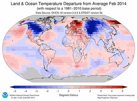
Much of North America and central Eurasia were plastered with unusually cold air (blue regions) during February 2014, while most other land areas on Earth ran warmer than average. (Image courtesy National Climatic Data Center.)
As people who've endured some of the worst cold and snow in decades try to reconcile that experience with the picture of a warming planet, they're also bracing for what 2014–15 might bring. A highly anticipated shift toward colder-than-average weather over the next few days across the central and eastern United States might be the first volley.
With a weak to perhaps moderate El Niño now expected to take shape, the U.S. winter outlook from NOAA calls for temperatures across the Midwest and Northeast to be near or above average, in line with what's most common during El Niño events. However, AccuWeather is calling for recurrent bouts of cold and snow in roughly the same area. These outlooks aren't directly comparable—for example, AccuWeather doesn't specify whether the northeastern cold and snow would be worse than in an average winter—but the contrasting tones do suggest differences of opinion about what's most likely to steer our upcoming winter.
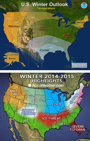
Two takes on our upcoming winter: seasonal outlooks issued in October by NOAA (top) and AccuWeather (bottom).
Likewise, there's major disagreement among scientists on exactly what might be causing the more general tendency toward colder winters in places like the central and eastern United States, Europe, and Russia. One factor is the Arctic, where depleted sea ice may be playing a role. Another is the tropical Pacific, where a tendency toward cooler-than-average sea-surface temperatures may also be involved.
The debate—one of the liveliest in weather and climate science today—is largely about which factor is most important.
The question of what's put the chill on northern midlatitude winters is tightly linked to debate over the "global warming hiatus," the widely publicized leveling of global temperatures that's run from the late 1990s into the early 2010s. As we've noted before, multiple studies indicate that the world's oceans have mopped up more heat than usual in this period and stored it at great depths, thus accounting for much of the hiatus. Scientists are still exploring which oceanic regions are most involved.
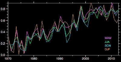
This graphic shows globally averaged temperature anomalies (deviations from a 30-year average) in degrees Celsius since 1970 as compiled by NOAA. Most of the hiatus in atmospheric warming since the early 2000s has occurred during the months December through February (DJF, the orange trace above). (Graph adapted from Figure 3 in An apparent hiatus in global warming? Earth's Future, doi:10.1002/2013EF000165.)
One fascinating aspect of the hiatus is that it's been concentrated in the months of December through February (DJF)—the period known as meteorological winter in the Northern Hemisphere. This interval has seen a slight drop in global temperature since the late 1990s, while the other nine months have held fairly steady (see map at right).
"The strongest pause is in the northern winter," said NCAR's Kevin Trenberth, who recently analyzed seasonal aspects of the hiatus with three NCAR colleagues in the journal Nature Climate Change.
While places like Chicago, New York, Berlin, and Moscow have had a few severe winters lately, they've also had some very mild ones. A much larger, more sustained region of cooling lies across the central and eastern tropical Pacific Ocean, where El Niño and La Niña play out (see map below). As it happens, La Niña—the periodic cooling of surface water across the eastern tropical Pacific—has predominated over El Niño since the late 1990s. Both El Niño and La Niña events tend to be at their strongest in DJF.
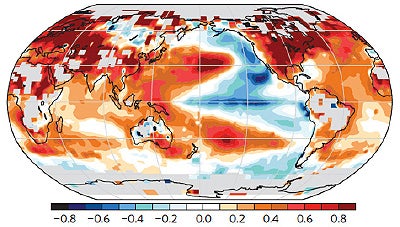
Where it's really cool: The map above was produced by subtracting average November-through-March temperatures for 1976–1998 from the readings for 1998–2012. The most prominent cooling can be found over the northeast Pacific and the eastern equatorial Pacific. (Figure 3(f) from Trenberth et al., Seasonal aspects of the recent pause in surface warming, Nature Climate Change, doi:10.1038/NCLIMATE2341.)
La Niña events typically last just a year or two, but a similar pattern can persist across the North Pacific for periods of 20 or 30 years—then flip to an opposite mode, more akin to El Niño, for another 20-30 years. This is the Pacific Decadal Oscillation, and it appears to have worked in concert with specific La Niña events to reinforce the cooler-than-normal waters at the equatorial surface since around 1998.
During La Niña, stronger-than-usual trade winds keep warmer equatorial waters shunted toward the western Pacific. Such long-lasting rearrangements can goose the atmosphere into persistent responses that extend over a great distance. Modeling experiments carried out for the Trenberth et al. paper suggest that, especially in DJF, the unusually warm equatorial waters toward the western Pacific near the equator have led to a train of rising and sinking air pockets, called quasi-stationary Rossby waves. Analyzed at the jet-stream level (about 6 miles high), this wave train arcs northward into Alaska, eastward across the Canadian Arctic, then back south over the North Atlantic.
Trenberth and colleagues argue that the wave train they identified could be the main culprit disrupting the "polar vortex" (the band of high-altitude winds that normally encircles polar regions), thus allowing for more southward intrusions of Arctic air and poleward surges of mild air.
However, another prominent view is that the topsy-turvy pattern might be primarily caused not by the tropical ocean but by the Arctic itself. Some of the leading researchers in this camp include Jennifer Francis (Rutgers University), Judah Cohen (Atmospheric and Environmental Research, or AER), and James Overland (NOAA Pacific Marine Environmental Laboratory). The Arctic-as-driver viewpoint has gotten major play in media coverage over the last several years, and research on it continues to accumulate.
Cohen began staking out theoretical territory starting more than a decade ago. Through a series of studies with colleagues at AER and the Massachusetts Institute of Technology, he found that greater-than-usual snowfall extent over Siberia during October correlates strongly with unusual cold and snow several months later, during the heart of winter, across the middle and higher latitudes of North America and Eurasia.
The idea, as AER's website explains, is that heavy autumn snow encourages the build-up of deep, cold air masses over Russia, accompanied by a persistent trough, or dip, in the jet stream. As autumn moves toward winter, Rossby waves propagate upward from the trough into the stratosphere, disrupting the polar vortex. This would encourage increased "waviness" in the jet stream and help foster southward-plowing Arctic outbreaks. It would also help explain why the atmospheric hiatus has been focused in DJF, as noted by Cohen and colleagues in 2012 and more recently analyzed in the Trenberth paper.
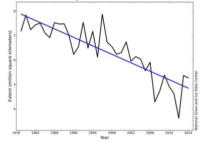
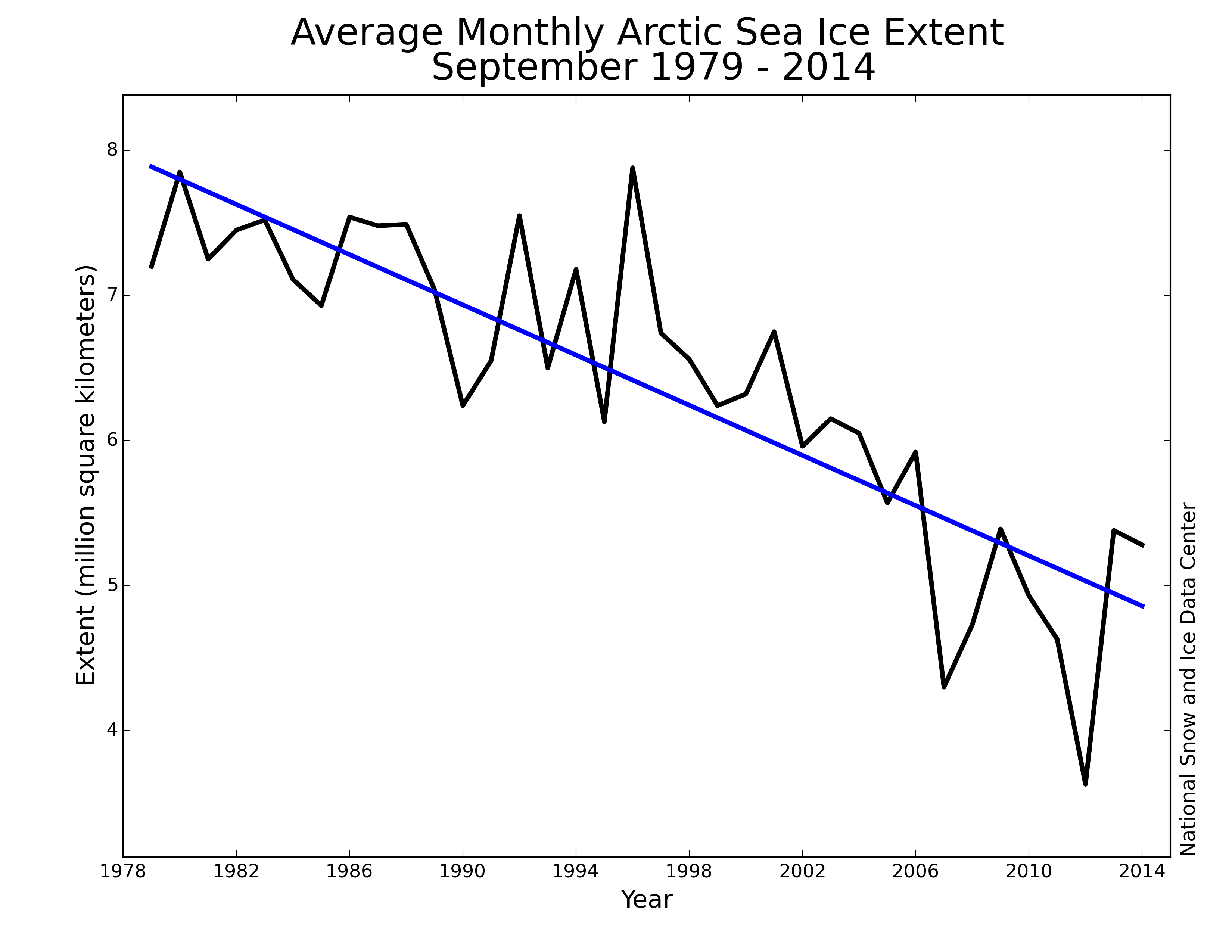
Arctic sea ice normally melts back to its minimum extent in September before regrowing in winter. The last 35 years show an unmistakable drop in September sea-ice extent across the Arctic. (Graph courtesy National Snow and Ice Data Center.)
Why would this chain of events occur more often today than, say, 20 or 30 years ago? The biggest change in recent years at high northern latitudes has been the dramatic loss of summer and autumn sea ice, especially since 2007. Cohen hypothesizes that moisture from the Barents and Kara seas—which are now largely unfrozen well into autumn—is helping pump up snowfall totals over Siberia, located just to the southeast.
While these two groups of scientists are often portrayed as being at loggerheads, it's possible that both of their hypothesized processes are at play. And perhaps it's too soon to tell. A review paper by Cohen, Francis, Overland, and eight other researchers, which appeared in Nature Geoscience in August, aims to identify what's generally accepted and what remains in question.
"We certainly do not discount a tropical influence on the Arctic or on midlatitude wave patterns," said coauthor James Screen (University of Exeter) in an email to AtmosNews. "Indeed, this has been shown in a number of studies."
Led by Cohen, the review paper focuses on Arctic amplification—the well-documented tendency of warming to be strongest at high latitudes, toward the North Pole—and its potential role in midlatitude weather extremes, especially during winter. This is a critical relationship to understand, especially since researchers agree that Arctic amplification is likely to continue. The current lack of consensus on the role of the Arctic in midlatitude weather, they suggest, "may help explain the media portrayal of a polarized view among scientists."
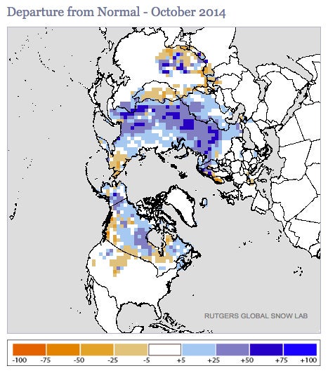
When compared to the 1981–2010 mean value, snowfall was more extensive than usual for October (blue and purple areas, in percent above average) across much of the Northern Hemisphere last month. In Eurasia, the amount of snow cover was the second largest (behind only 1976) for any October since satellite monitoring began in 1967. Researchers have connected October snowfall in Eurasia to an increased risk of midlatitude cold outbreaks in the winter. (Map courtesy Rutgers Snow Lab.)
The paper notes that both observational analyses and modeling studies lend some support to Cohen's hypothesis involving autumn snow cover in Eurasia. The review also suggests that, along with helping to produce increased snow cover, the delayed freeze-up of nearby sea ice could itself work in tandem with the Siberian cold and snow to displace the jet stream in autumn and produce a more variable polar vortex by early winter. One analysis published in September outlines the physics behind this chain of events, and another recent study suggests that the odds of severe winters in central Eurasia have roughly doubled because of the reduced Barents and Kara sea ice.
"I think we can now say that this mechanism has transitioned from a hypothesis to a theory," said Jennifer Francis in an email to AtmosNews.
On the other hand, Trenberth argues that the tropical oceans, though distant from the Arctic, hold a vastly larger store of energy, and thus any rearrangement of tropical water ought to have an outsized impact on mid- and high-latitude winter weather. Arctic amplification "is a consequence, not a cause" of the unusual jet-stream patterns, according to a recent essay by Trenberth. He joined John Wallace (University of Washington) and several other leading researchers in a letter published in Science last winter urging caution in attributing Arctic amplification and midlatitude extremes to sea-ice loss.
Given enough time, this now-cooking debate could prove moot. A number of scientists expect that by later in the century, overall global warming—amplified in the Arctic—should predominate. A three-year project led by NCAR's Clara Deser and Lantao Sun is now working to quantify the longer-term picture. Their approach: Using two climate models (from NCAR and the UK Met Office) that extend up through the stratosphere, vary the amount of Arctic sea ice, and then look for the effects on mid- and high-latitude climate toward the latter part of this century. Initial results are now being finalized for a soon-to-be published paper.
As for the coming winter, snow cover extent across Eurasia in October came in as the second most extensive on record—perhaps a chilly portent. Cohen will be posting a winter outlook in an annually updated report on the NSF website by the end of November. Meanwhile, according to a post by Mashable's Andrew Freedman, NOAA is considering a shift in its own winter outlook in a scheduled November 20 update, in light of the ample Siberian snowpack, El Niño's lackluster onset, and other factors.
If global warming does eventually make the roughest winters increasingly rare, it's easy to envision today's youngsters telling their own grandkids about what conditions were like during the legendary cold and snow of the 2010s.
Writer/contact
Bob Henson, NCAR/UCAR Communications