Fanning the flames of megafires
Local winds are the key factor in some conflagrations
Jul 24, 2018 - by David Hosansky
Temporary impacts to NSF NCAR Road, Parking Lot and Trails
View more information.Jul 24, 2018 - by David Hosansky
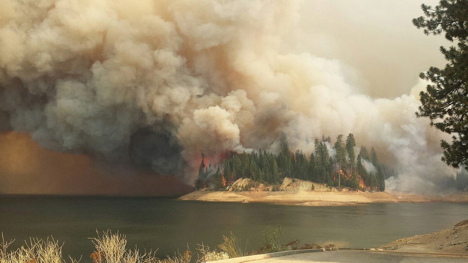
The King Fire burning in California in 2014. (Image: U.S. Forest Service)
Although drought and overgrown forests are often blamed for major fires in the western United States, new research indicates that various types of highly localized winds sometimes play a much larger role, creating large, destructive fires even when regional winds are weak.
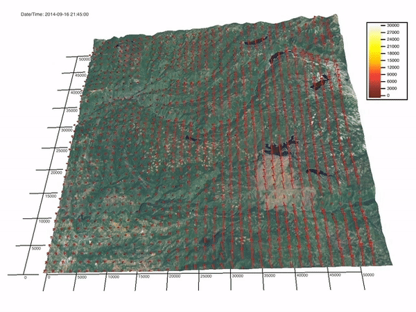
The study, led by the National Center for Atmospheric Research (NCAR), uses forest observations and advanced computer simulations of the 2014 King Fire, which burned more than 97,000 acres in the Sierra Nevada mountains during California's severe multiyear drought.
Although nearby weather stations measured weak winds, the study team found that the reason the fire suddenly ran 15 miles up a canyon one afternoon was actually due to winds — both very localized winds related to topography, as well as those created by the searing heat of the flames. Such winds, sometimes only a few hundred yards across, often go undetected by weather stations that may be several miles away.
The scientists also found that these very localized winds played a larger role in the fire's quick and destructive growth than the underlying drought conditions or the amount of fuel that had accumulated in the forest.
"This brings into question several widely held and largely unquestioned assumptions, such as very large fires being caused by the accumulation of vegetation or persistent dry conditions, or requiring extreme conditions," said NCAR scientist Janice Coen, the lead author of the study. "Even though the winds measured by nearby weather stations were weak, smaller scale localized winds and winds generated by the fire that we and fire management couldn't detect in real time turned out to have a much greater impact on this fire, and potentially others like it, than any of the other factors."
The research may have ramifications for thinning trees and underbrush and for anticipating fire behavior, she added.
The study, published in Ecological Applications, was co-authored by scientists from NASA's Jet Propulsion Laboratory and the U.S. Forest Service. The research was funded by the Federal Emergency Management Agency's Assistance to Firefighters Grant Program and by NASA.
Very large, high-impact fires known as "megafires" are becoming more frequent in the western United States, and perhaps worldwide. Many experts have attributed this to some combination of a changing climate, which is causing hotter and sometimes drier conditions, and a century of fire suppression policies in forests that have led to more vegetation, providing increased fuel for flames.
These hypotheses, however, cannot easily be tested. Since scientists cannot readily experiment with large and destructive fires, they instead have fallen back on examining statistical correlations to try to tease out the key factors associated with megafires.
But Coen and her co-authors had a rare opportunity to recreate an actual wildfire within a sophisticated computer model and test the effects of drought and fuel load. The same area consumed by the King Fire had been previously mapped by NASA and the Forest Service, which used lidar and other instruments to create an extensive database about the forest structure and vegetation types. In addition, the authors had access to airborne thermal imagery collected during the fire.
To examine the conflagration, the authors turned to the NCAR-based CAWFE® modeling system (the acronym stands for Coupled Atmosphere-Wildland Fire Environment). CAWFE combines weather prediction with fire behavior to capture the highly complex interplay of fire and atmosphere. They used the modeling system to reproduce key features of the actual fire and to create alternative scenarios with altered drought and vegetation conditions.
The authors found that more severe drought conditions did not change the ultimate extent of the fire or greatly alter the fire’s expansion in areas of rolling hills. Similarly, reducing the fuels on the surface by half in the model, or tripling the amount of vegetation in the tree canopy, did not substantially affect the fire in rolling hills or increase its overall extent.
The increased vegetation and drought conditions did speed the fire moderately when climbing the canyon because the fire generated a strong updraft that drew the flames more quickly up the slope. While drought severity and vegetation density had little impact while the fire was traveling over flatter ground, they had a multiplier effect in the upward-sloped canyon, along with the accelerating influence of inclined terrain.
"This is just one case but it illustrates how the causes of a megafire have sometimes been misunderstood," Coen said. "Though different factors will have varying degrees of impact at different places on different fires, the mechanisms and environmental factors that shape fires are the same."
She and co-author E. Natasha Stavros, an engineer with NASA's Jet Propulsion Laboratory, also noted that the extensive observations allowed them to differentiate between types of vegetation in the forest, which helped improve model simulations—especially for areas that had already been disturbed or where the burn severity was greatest.
"The NASA airborne measurements were unique in that we observed the forest’s vertical structure before and after a fire," Strovos said. "These observations let us better identify the type of fuel — grass, shrubs, or trees. That improved the model simulations, particularly of how the fire spread in areas where previous fires had burned or timber had been harvested, and in areas where the burn severity was greatest."
The authors did not discount the correlation between drought and area burned, suggesting such a relationship could become evident when the effects of drought are summed up over many fires. But they said more research is needed to better understand the influence of drought on megafires.
The study underscores the importance of recognizing the role of very fine-scale winds to better understand and predict the behavior of megafires, Coen said. Sudden accelerations in the flames's advance can surprise firefighters because real-time weather forecasts often do not reveal highly localized winds and complex fire-atmosphere feedbacks.
The authors see potential for this type of computer modeling to help inform future wildland fire policies, including efforts to reduce megafires, strengthen forest resilience, and protect ecosystems.
"This modeling might be used to rethink and reprioritize mitigation strategies, because actions might have less or more impact than believed," Coen said. "For example, maybe fuel reduction should focus on slopes, because the fuel has the biggest impact on fire behavior there."