NSF NCAR scientists participate in mission to measure air quality over Asia
NASA-led ASIA-AQ campaign will help verify and interpret new satellite observations
Feb 12, 2024 - by Laura Snider
Early closure on July 3 and 4 - NSF NCAR Road, Parking Lot and Trails
View more information.Feb 12, 2024 - by Laura Snider
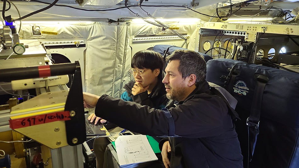
Scientists with NSF NCAR's Atmospheric Chemistry Observations and Modeling lab (ACOM) work on the chemiluminescence instrument that is being deploying on the NASA DC-8 to measure nitrogen oxides and ozone. The scientists are: Changmin Cho (left, ACOM postdoctoral fellow) and Alessandro (Ale) Franchin (right, ACOM project scientist). (Photo courtesy of Rebecca Hornbrook, NSF NCAR.)
Scientists from the U.S. National Science Foundation National Center for Atmospheric Research (NSF NCAR) have begun a four-country deployment focused on obtaining airborne observations of air quality over some of Asia’s largest cities.
The observations, part of the NASA-led Airborne and Satellite Investigation of Asian Air Quality (ASIA-AQ) mission, will be used to help verify and interpret new satellite observations. Ultimately, the data collected will lead to a better understanding of factors that influence air quality over some of the world’s largest megacities and help improve complex air quality models.
The international team of researchers — which includes more than two dozen NSF NCAR staff, mostly from NSF NCAR’s Atmospheric Chemistry Observations and Modeling Laboratory (ACOM) — kicked off the ASIA-AQ campaign in the Philippines this week. Over the next two months the researchers will also go to Malaysia, South Korea, and Thailand.
ACOM has three instruments deployed on NASA’s DC-8 research aircraft and is also providing air quality modeling for the campaign.
“ACOM is able to contribute valuable expertise and capabilities to these types of air quality missions,” said NSF NCAR scientist Louisa Emmons, who serves on the mission’s U.S. Steering Group. “The measurements taken by our instruments and the forecasts provided by our models will be critical components of the campaign. We are delighted to partner with our colleagues, both nationally and internationally, to improve our understanding of local air quality, which has such large impacts on people’s day-to-day lives and long-term health.”
Connecting the sky and ground
A primary purpose of the ASIA-AQ mission is to connect satellite measurements of air quality with ground-based observations. In particular, South Korea launched a new satellite instrument, the Geostationary Environment Monitoring Spectrometer (GEMS), in 2020. The instrument measures both trace gases and aerosols and, for the first time, provides those measurements hourly for more than 20 countries in Asia.
“Before the geostationary satellite, we only had a snapshot once a day for a lot of these places,” said NSF NCAR scientist Rebecca Hornbrook, who is participating in the campaign. “Now we have a full day’s worth of information that can help us understand what’s influencing the air quality at different times of the day and how emissions and chemistry change throughout the day.”
To ensure that the satellite data are being interpreted correctly, scientists need to validate it with observations closer to the ground. This is because satellites do not measure trace gases in the atmosphere directly. Instead they rely on measuring wavelengths of light, which are absorbed or emitted by different chemical species. The spectrum of light that makes it to the satellite can give scientists a picture of the composition of the atmosphere. However, because the light waves can also be affected by other factors, including humidity and scattering by aerosols, the observations must be interpreted with caution.
While a network of ground-based instruments also provides observations of air quality at discrete points, airborne observations can connect the lower-resolution remotely sensed data from above with the high-quality, but extremely localized observations from below. Aircraft can also vary their altitude, collecting information on how chemicals in the atmosphere are distributed vertically. In contrast, satellites cannot generally distinguish where many pollutants being measured are located — close to the ground or higher up in the atmosphere.
“Having an airplane fly through air pollution plumes with a full chemical lab onboard allows us to bridge the gap between satellite and surface measurements and enable better interpretation of long-term measurements,” said NSF NCAR scientist Samuel Hall, who is the principal investigator (PI) on one of the three ACOM instruments being used for ASIA-AQ.
ASIA-AQ involves two NASA aircraft: a Gulfstream III and a DC-8. The ACOM instruments will be onboard the DC-8 and include:
ASIA-AQ is also drawing on daily air quality forecasts using ACOM’s Multi-Scale Infrastructure for Chemistry Modeling (MUSICA) and the NSF NCAR–based Weather Research and Forecasting Model (WRF) with tracers of pollutant sources. The ACOM chemical forecasting team, led by Emmons — along with other forecasting teams from the Naval Research Laboratory, University of California Los Angeles, University of Iowa, NASA and local institutions in each study region — will give the scientists an idea of what they can expect to find during the day’s flights. The measurements will be used to evaluate and improve the models, and, in turn, the models will provide context for interpretation of the observations.
The data collected will be made freely available to local partners, who will also be full participants in the campaign. Having strong local partnerships ensures that the data are as useful as possible to agencies in the host countries.
The mission wraps up at the end of March. For more information or to track the NASA aircraft along the way, visit the NASA ASIA-AQ web page.