Hyperlocal wind forecasts are on the horizon
NSF NCAR researchers investigate neighborhood-level wind prediction
Jun 10, 2026 - by Audrey Merket
Early closure on July 3 and 4 - NSF NCAR Road, Parking Lot and Trails
View more information.Jun 10, 2026 - by Audrey Merket
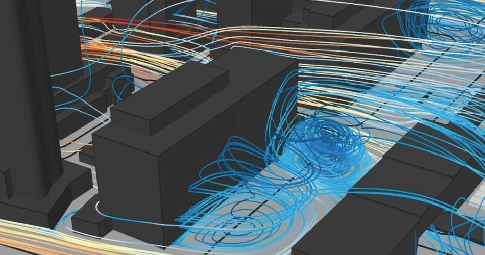
NSF NCAR researchers are working on capturing winds at exceptionally high resolution, revealing wind gusts and eddies along individual streets and around corners.
| Impact statement: The development of hyperlocal wind forecasts would provide decision-makers and emergency responders with neighborhood-level weather insights to better prepare for and respond to extreme events such as wildland fires and power disruptions. |
Wind is the driving force behind many damaging weather phenomena. It can fan the flames of wildfires, topple trees onto powerlines, and cause dangerous conditions for aircraft during takeoffs and landings. However, these small-scale wind events that have major impacts on society are challenging to accurately predict.
Researchers at the U.S. National Science Foundation National Center for Atmospheric Research (NSF NCAR) are working on a major new project to predict low-altitude winds with improved accuracy and more granularity. This capability would provide decision-makers and emergency responders with neighborhood-level weather insights to better prepare for and respond to extreme events such as wildland fires and power disruptions.
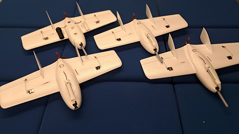
Current weather models lack the resolution to capture key features of the local topography that can influence near-surface winds. For predictions to be accurate at the neighborhood scale, natural and man-made elements, such as buildings and trees, also need to be accurately modeled. Over the next five years, NSF NCAR researchers will collaborate with researchers at the University of Kentucky to improve models for wind predictions by blending weather observations from uncrewed aircraft systems (UAS) with a technique called large eddy simulation that enables scientists to model turbulence and wind behavior near the Earth’s surface.
“One of our goals is to enable support for real-time wildland firefighting as well as pinpoint what parts of the energy distribution network are most likely to be impacted by a high-wind event to inform more strategic power shutoffs,” said James Pinto, an NSF NCAR scientist and principal investigator of the project. “This really is cutting-edge research. We're able to simulate the influence of a collection of buildings or a canopy of trees on low-altitude winds and turbulence in real time.”
The project is titled “LEAP-HI: Advancing Precision Neighborhood Scale Weather Forecasting with Autonomous Aircraft Systems and Adaptive Microscale Models.” It is funded through NSF’s Leading Engineering for America's Prosperity, Health, and Infrastructure (LEAP-HI) program.
In order to model near-surface winds with greater accuracy, the team is primarily leveraging two tools: a model called FastEddy that is being developed at NSF NCAR and observations obtained with a fleet of UAS owned by the University of Kentucky.
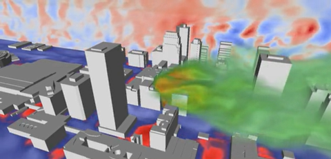
FastEddy is a model that predicts temperature, humidity, and winds at resolutions so fine that it can capture individual swirling pockets of wind. FastEddy can use idealized wind conditions or real-world forecast outputs to drive the simulations. The simulations are being run on the Derecho supercomputer at the NSF NCAR-Wyoming Supercomputer Center. In real-world simulations, small errors in the model and forecast data can have a big impact on the accuracy of predicting low-altitude winds, particularly in urban areas. The research team is hoping that observations from UAS will help remedy this.
Measurements from state-of-the-art UAS and a micro-network of turbulence sensors distributed across the University of Kentucky’s flight facility will be combined with model adaptation techniques to improve the predicted winds and turbulence. The FastEddy model simulations will be evaluated against the observations. If differences between the predictions and observations still exist, the new observations will be used to tweak the inputs and parameters that drive FastEddy and further improve its predictions.
Pinto and his colleagues hope that this research will ultimately lead to more accurate predictions of low-altitude winds at a resolution as fine as two meters, or about the length of a queen-sized mattress.
Once the researchers have established the technique to improve the FastEddy simulations using UAS observations at the flight facility, they will perform additional testing at other locations with more complex terrain and land surface characteristics. While the project is focused on only a few specific areas, Pinto and his colleagues anticipate there will be overarching principles that can be applied to other regions and applications.
Beyond safeguarding communities from severe weather, this type of prediction tool is highly sought after in the emerging industry of urban air mobility (UAM). As government agencies and private companies look at developing UAM operations that could move people and cargo within urban environments via drones and air taxis, this FastEddy modeling approach could help guide infrastructure planning, operational efficiency, and safety.
“There are a lot of applications for hyperlocal wind predictions,” said Pinto. “We’re just at the beginning of this research project, but we’re excited to see what we learn and how significantly we can improve low-altitude wind predictions.”
FastEddy is a community, open-source model for large eddy simulation (LES) of microscale weather that is being developed at NSF NCAR by Jeremy Sauer and Domingo Muñoz-Esparza. The system runs on graphical processing units (GPUs), which are much more efficient and faster than traditionally used central processing units (CPUs), allowing for simulations of the lower atmosphere at very high resolutions that can actually resolve the impact of trees and buildings on near-surface winds and turbulence. The latest version, FastEddy 5.0, was released in May.