What's driving soot across India?
Short-lived black carbon emissions provide mitigation opportunity
Oct 12, 2015 - by Staff
Oct 12, 2015 - by Staff
October 12, 2015 | As a teenager in the 1990s, NCAR postdoctoral scientist Rajesh Kumar bicycled five miles from his village north of Delhi to school. He remembers riding through clear skies and fog, but not smog.
Today, Delhi ranks as the most polluted city in the world with 12 additional Indian cities in the notorious top 20, according to the urban air database released last year by the World Health Organization. In Delhi alone, small particulates averaged six times the recommended maximum, a hazard to the health especially of children and the elderly. Smog also contributes to climate change by trapping heat that otherwise would escape the atmosphere.

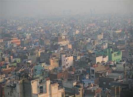
Scientists have identified the sources and transport patterns of black carbon soot, a health and visibility problem for a dozen Indian cities, including Delhi, shown here enveloped in smog. (Photo by Jean-Etienne Minh-Duy Poirrier, Creative Commons [CC BY-SA 2.0], via Flickr.)
Experiencing increased air pollution in his home country has inspired Kumar to understand more about its driving forces and remedies. Most recently, the researcher was lead author on a paper concluding that black carbon emissions—fine particles or soot caused by the incomplete burning of fossil fuels and biomass from plant or animal waste—are transported in the atmosphere across India. Only 5 percent of the emissions at any given time blow in from outside the country.
Black carbon emissions from northern India, for example, contribute up to 30 percent to black carbon pollution in southern India during the winter, the study found, while southern India makes a similar contribution to northern India during the summer monsoon season. While human activity—agricultural waste burning, use of household cook stoves, industry and vehicles—is the cause of most black carbon emissions, the seasonal cycle is driven by the monsoon weather.
"What this means is that India has the power to reduce black carbon emissions significantly—but only if individual states and regions work together on mitigation strategies," said Kumar. The paper appears in the Journal of Geophysical Research – Atmospheres. A research team headed by Kumar now is conducting a simulation of how air quality is likely to change in South Asia overall by mid-century, a topic he will discuss at the American Geophysical Union’s fall meeting in December.

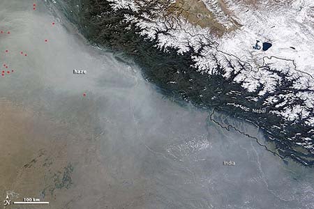
Haze from urban and industrial pollution, as well as agricultural and wildland fires (red dots), can be seen over northern India below the Himalayan mountain range in this satellite image from October 2014. (Photo courtesy NASA.)
Co-author Mary Barth, an NCAR scientist, noted that attention to black carbon emissions has grown as more is known about its ability to strongly absorb solar radiation. The issue is especially of concern in densely populated areas such as the Indo-Gangetic Plain, which consists of Bangladesh and swaths of India and Pakistan. There is concern not only due to black carbon's atmospheric impacts, but also because soot that settles on snow absorbs more heat from the Sun and thus accelerates melting. Emission levels are so high in that region that there is concern about glacier melt in the Himalayas—the region's primary storehouse of water.
"If you curtail black carbon emissions, you can reduce heat over the short term," Barth said. "It's something you can do while working to reduce carbon dioxide levels in the atmosphere." Black carbon has a short life span of only a week or two, while carbon dioxide molecules remain in the atmosphere for about 100 years.
Prior studies have provided important information about black carbon pollution in parts of India, but they didn't detail the specifics of how the particles are transported across the country.
For their observational database, the research team used monthly average black carbon concentrations reported from 21 sites representing a range of environments, including cities, semi-urban areas, and coastal areas. They also took meteorological data into account. The team then developed models for tracking air pollutants that were combined with the NCAR-based Weather Research and Forecasting Model.

NCAR researcher Rajesh Kumar studies black carbon emission levels. (©UCAR. Photo by Carlye Calvin. This image is freely available for media & nonprofit use.
While the computer model reproduced the seasonal cycle of black carbon emissions fairly well, it was more difficult to capture that seasonality in the complex terrain of the Himalayan region.
Kumar, who also has studied the impact of ozone pollution on India's agriculture production, notes that India is taking steps to improve its air quality. Efforts include national programs to promote liquefied petroleum gas for cooking and solar power for energy production and irrigation.
"I hope that in 20 years or so, India will be able to talk about its good air quality, not its pollution," Kumar said.
Rajesh Kumar, M. C. Barth, G. G. Pfister, V. S. Nair, Sachin D. Ghude, and N. Ojha, 2015: What controls the seasonal cycle of black carbon aerosols in India? Journal of Geophysical Research - Atmospheres, 120, 7788-7812, DOI: 10.1002/2015JD023298 | OpenSky
Variability in emission levels was simulated by applying a tagging technique developed by Kumar. The technique consists of assigning 10 different values or "tracers" to standard black carbon particles in order to track the emissions from different regions and sources. For example, separate tracers were assigned to emissions from four regions of India and from outside the country to determine geographic variability.
Traditionally, researchers would have done a separate simulation for each tracer, or variable. Putting all 10 tracers in the model at the same time saved a tremendous amount of computing time, Kumar said. The data, crunched by the NCAR-Wyoming Supercomputing Center's Yellowstone system, took only about a tenth the time of the traditional method.
Writer/contact
Jeff Smith, Science Writer and Public Information Officer
Collaborating organizations
Indian Institute of Tropical Meteorology
Max Planck Institute for Chemistry, Germany
Vikram Sarabhai Space Center, India.
Funder
National Science Foundation