Patricia: A global view
Record-setting hurricane's connections are far-reaching
Oct 23, 2015 - by Staff
Temporary impacts to NSF NCAR Road, Parking Lot and Trails
View more information.Oct 23, 2015 - by Staff
October 23, 2015 | As the most intense hurricane on record in the Western Hemisphere, Hurricane Patricia is taking direct aim at Mexico’s Pacific coast and expected to spawn impacts as far away as Texas and the central United States.
This image, created with a specialized visualization system built at the University Corporation for Atmospheric Research, shows Patricia's strength as it approaches Mexico as well as the connections the storm is making with other atmospheric disturbances further away. It uses global satellite infrared measurements that produce thermal images of clouds. The reds and blues show colder, higher cloud tops that are associated with towering cumulus clouds and more powerful storms.
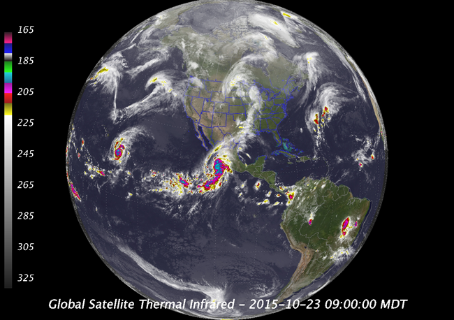
With Patricia and its 200 mile-per-hour winds bearing down on them, residents across a broad region of southwestern Mexico are being warned to prepare for potentially catastrophic impacts.
The storm also is beginning to interact with low pressure over the central United States. The image shows how Patricia's outer reaches flow into a band of clouds that stretches across the country's mid-section. This connection is expected to feed the low-pressure system, potentially bringing more rain to parts of the country. After Patricia moves inland tonight, the storm’s central core will be torn apart by Mexico’s mountains but its incredible moisture will continue on to Texas, where forecasters fear a major flooding event in the next two to three days.
Patricia also appears to be interacting with Hurricane Olaf, a less-intense system clearly visible in this image in the central Pacific, far to the west of Patricia.
"When we look at a hemispheric view like this, we can see teleconnections across thousands of miles," said Jeff Weber, a meteorologist with UCAR’s Unidata program who created this image. "Olaf and Patricia are in phase with each other, and their movements appear to be related. Patricia may be drawing in some of the moisture that Olaf is bringing up into the atmosphere."
Although not directly linked to the hurricanes, the V-shaped cloud structure in the northern Pacific also signals stormy weather ahead. These are a pair of extratropical cyclones creating an amplified wave train. This will likely affect the U.S. west coast over the next seven to ten days, creating stormy and windy conditions, with cold air to the south and warm air to the north.
"We’ve got a lot of activity in this part of the world right now," Weber said. "It's all related to El Niño and the unusually warm waters in the Pacific."
Weber made the image using the Integrated Data Viewer. This specialized software, created by Unidata, helps scientists visualize and analyze atmospheric conditions.
Writer/contact
David Hosansky