Taking the temperature of planet Earth
COSMIC satellites provide reliable thermometer in the sky
Jan 7, 2016 - by Staff
Temporary impacts to NSF NCAR Road, Parking Lot and Trails
View more information.Jan 7, 2016 - by Staff
January 7, 2016 | Just how warm is Earth, anyway?
With the recent climate talks in Paris—where representatives from nearly 200 countries negotiated a deal that aims to limit warming this century to 2 degrees Celsius—it's a question many people are asking. It's also deceptively difficult to answer.
Directly measuring the temperature at the surface of Earth, where the 2-degree Celsius goal applies, is hard. In part that's because Earth's surface is not covered in thermometers, and in fact, there are vast regions of the planet—including the oceans and polar regions—with no thermometers at all. But even if it were easy, the information would not give us the full picture of the amount of heat trapped in the atmosphere, which is hundreds of miles thick. Observations of temperature change throughout the atmosphere are needed to better detect and understand climate change.
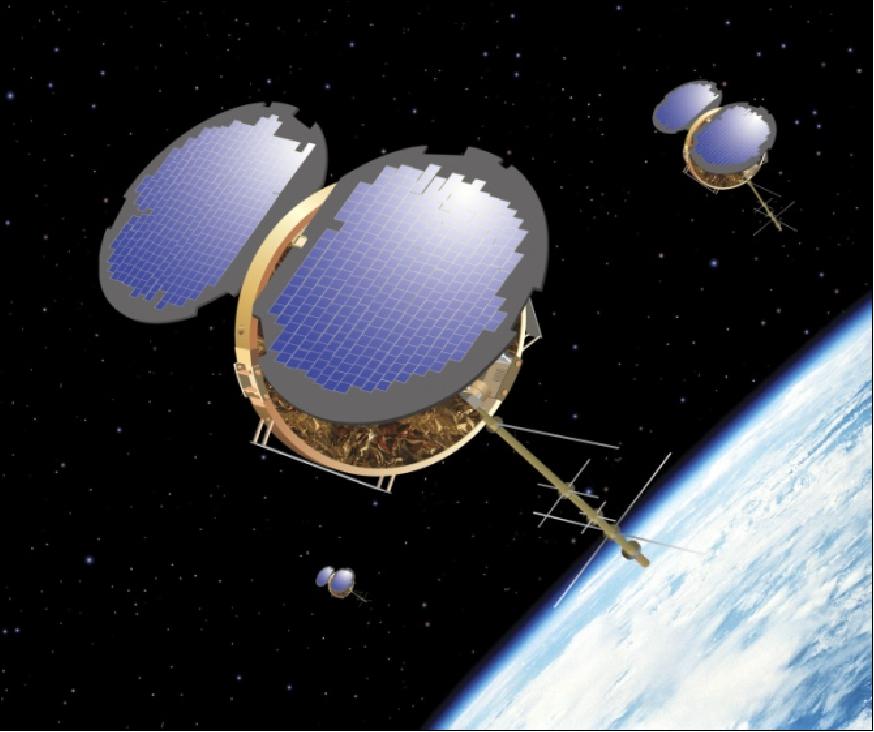
An artist's rendering of the COSMIC satellites. (Image courtesy UCAR Community Programs/COSMIC)
Thanks to a fleet of six microsatellites launched almost a decade ago, scientists have access to a new database of temperature records that sprawl out in three dimensions through the lowest layers of the atmosphere. A partnership between the United States and Taiwan, the satellite system has proven to be an extremely accurate, precise, and stable space-borne thermometer, especially for the upper troposphere and lower stratosphere, a region important to our understanding of climate change.
Called COSMIC—the Constellation Observing System for Meteorology, Ionosphere, and Climate—the system makes measurements of several key attributes of the atmosphere that are used to improve weather forecasting. COSMIC is a collaborative effort, conceived, planned, and managed by the University Corporation for Atmospheric Research (UCAR) along with the National Science Foundation, NASA, the National Oceanic and Atmospheric Administration, U.S. Air Force and Taiwan's National Space Organization.
Despite the paucity of surface temperature observations in certain parts of the world, there is enough data collected by land-based weather stations and by ships at sea for scientists to come up with an average
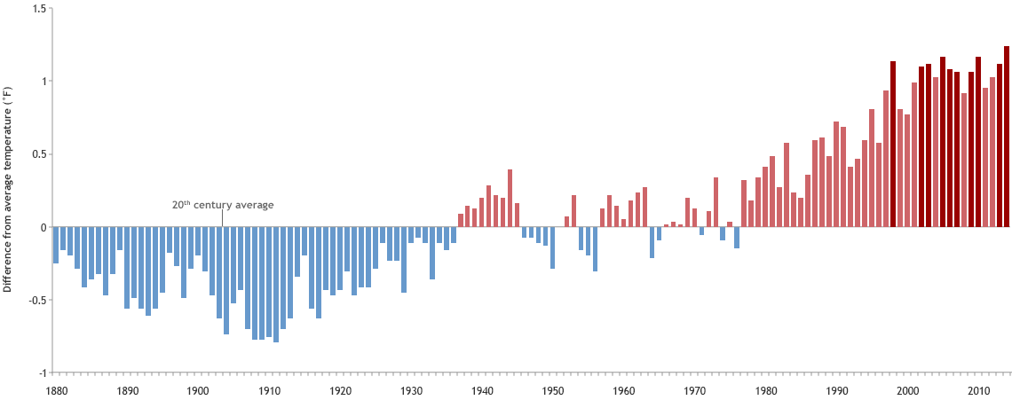
Annual temperatures since 1880 compared to the 20th-century average. Click image to enlarge; click here to learn more about this graph. (Graph by NOAA Climate.gov, based on data from the National Climatic Data Center.)
annual global surface temperature all the way back to 1880. They do this with the help of sophisticated computer models that fill in the gaps.
For the last several decades, scientists also have been able to glean temperature information from another source entirely: satellites.
Satellites do not measure temperature directly, but temperature information can be derived from other measurements taken by instruments on board. Traditionally, this has meant measuring how much microwave and infrared radiation is emitted by several gases in the atmosphere. With this information, scientists can calculate the temperature of atmospheric layers. To be accurate, this method requires periodic recalibration because the sensitivity of the sensor used to take these measurements can change over time.
When COSMIC was launched in April 2006, however, scientists gained a new way to measure temperature from space that doesn't require any calibration.
COSMIC uses a technique called radio occultation to create a profile of atmospheric conditions, including temperature. Radio occultation is not new; it was first developed in the 1960s for use by NASA's Mariner 4 spacecraft to probe the properties of Mars' atmosphere. But the launching of GPS (Global Positioning System) satellites beginning in the late 1970s created an opportunity for radio occultation to be used to learn more about our own atmosphere.
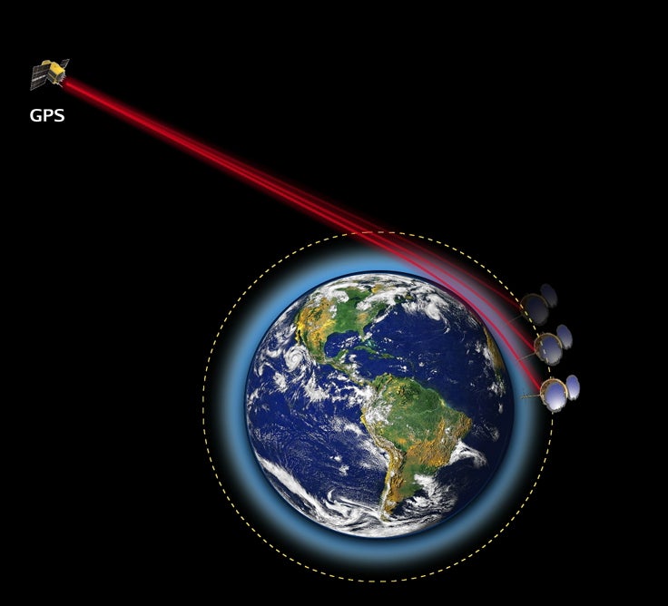
COSMIC microsatellites intercept radio waves from GPS satellites at Earth's horizon, where they measuree the bend and delay of the signal. (Illustration courtesy UCP/COSMIC.)
Radio occultation works by measuring the degree to which radio signals bend and slow down as they travel through a planet's atmosphere: the denser the atmosphere, the greater the curve and delay of the signal. Because temperature, pressure, and moisture affect the density of the atmosphere, scientists can work backwards to determine the values for these properties.
The COSMIC satellites, which are in a low-Earth orbit about 500 miles up, intercept signals from more than 24 GPS satellites that are orbiting higher above them. By catching the signal just at Earth's horizon, COSMIC's instruments can precisely measure the signal's bending and delay.
Radio occultation does not require any calibration because GPS satellites keep time using ultra-stable atomic clocks. Since the time is known precisely, COSMIC satellites are able to accurately and precisely measure the delay of the signal coming from the satellite.
"These accurate and precise measurements are important for determining the true variations in global and regional atmospheric temperatures, whether from natural variability or long-term climate change," said Rick Anthes, senior advisor to the COSMIC program and president emeritus of UCAR. "Without these measurements, the true variations are partially hidden by measurement errors and uncertainties."
The temperature data gleaned from COSMIC is most reliable in the upper troposphere and lower stratosphere, about 5–15 miles above the surface of Earth.
"The temperature and temperature changes in these layers are very important in climate and climate change," Anthes said. "For example, climate models project a warming of the upper troposphere and a cooling of the lower stratosphere in response to increasing greenhouse gases. These projections can be accurately and precisely checked by radio occultation."
And in fact, the observations made so far by COSMIC appear to support these projections. But decades more of radio occultation observations are needed to determine the long-term trend.
A second phase of the COSMIC program is planned to do just that. COSMIC-2, which is a partnership between NOAA, the U.S. Air Force, and Taiwan, is divided into two separate launches of six satellites each. Together, the two launches will provide a total of 10 times the previous number of daily occultations. The first six satellites are scheduled to be launched in 2016 into an equatorial orbit, where they will provide valuable data for hurricane forecasting. The second launch—which is targeted for 2019—will put six satellites into polar orbit. However, complete funding for the second launch, which is critical for forecasting in the polar regions and the middle , where most of the world's population lives, has not yet been approved by Congress.
"COSMIC and other radio occultation missions have proven to be valuable for not only climate monitoring, but also for global weather forecasts and for measurements in the ionosphere, which are important for space weather," Anthes said. "COSMIC-2 will improve on COSMIC by providing many more observations of higher quality, further supporting these important scientific areas and applications that have big benefits for society."
Writer/contact
Laura Snider, Senior Science Writer and Public Information Officer