Scientists to track twisters in world’s largest tornado study
Apr 28, 2010 - by Staff
Apr 28, 2010 - by Staff
BOULDER—More than 100 researchers will begin deploying a flotilla of instruments across the Great Plains next week, aiming to surround tornadoes with an unprecedented fleet of mobile radars and other cutting-edge instruments in the second and final year of the most ambitious tornado study in history.
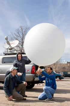
 NCAR scientists and technicians will launch weather balloons at VORTEX2 with their Mobile GPS Advanced Upper-Air Sounding System. Shown here are (left to right) William Brown, Jennifer Standridge, and Tim Lim testing a balloon launch (©UCAR, Photo by Carlye Calvin.) News media terms of use*
The collaborative international project, involving scientists from the National Center for Atmospheric Research (NCAR) and a number of other organizations, examines in detail how tornadoes form and the patterns of damage they cause. The findings are leading to a greater understanding of tornadoes, and scientists expect they will ultimately improve tornado warnings and short-term severe weather forecasts.
The field campaign, known as VORTEX2 (Verification of the Origins of Rotation in Tornadoes Experiment 2), runs from May 1 to June 15. It covers the most active part of tornado season on the Great Plains, where violent twisters are more common than any other place in the world.
“Tornadoes rank among the most destructive weather events on Earth, and it’s imperative that we learn more about how they develop and why some are so powerful and long-lived,” says David Dowell, an NCAR scientist who is a principal investigator on the project. “We’re hoping to improve the lead time and accuracy for tornado warnings. If we can understand these forces better, that could ultimately save lives.”
During the first phase of VORTEX2 last spring, researchers made key observations of a tornado in southeast Wyoming that was rated EF2 on the Enhanced Fujita tornado damage scale. They also collected data on several powerful nontornadic storms. Such information will help researchers distinguish between thunderstorms that produce tornadoes and those that do not. This year’s study period is about two weeks longer than last year’s, which enhances the odds of tracking down tornadoes.
The $11.9 million VORTEX2 program is funded primarily by the National Science Foundation, which sponsors NCAR, and by the National Oceanic and Atmospheric Administration (NOAA).
In addition to NCAR, participants include the Center for Severe Weather Research, Rasmussen Systems, NOAA National Severe Storms Laboratory, NOAA Cooperative Institute for Mesoscale Meteorological Studies at the University of Oklahoma, Pennsylvania State University, Texas Tech University, Lyndon State College, Purdue University, North Carolina State University, the universities of Oklahoma, Colorado, Massachusetts, and Nebraska, Environment Canada, and the Australian Bureau of Meteorology.
The first VORTEX project, conducted in 1994 and 1995, gathered critical data on supercells, the severe and long-lived thunderstorms that give birth to the most destructive and deadly tornadoes. VORTEX findings are credited with improving National Weather Service tornado warnings.
Building on that progress, VORTEX2 researchers are using an armada of enhanced mobile radars and other new weather-sensing tools to gather far more detail on the crucial zone where tornadoes develop. Rapidly changing contrasts in wind and temperature in this zone, which is only a few miles across, can spawn a tornado within minutes. However, this happens in only a small fraction of supercell storms, and standard observing networks and radars often fail to capture the atmospheric conditions that lead to a tornado.
Among the key questions that VORTEX2 researchers want to answer:
To capitalize on the unusual mass of mobile instruments, researchers will also look for opportunities to collect data on other major weather events in the region. A team of VORTEX2 scientists last year, for example, made unusually detailed observations of squall lines, which can produce damaging hail and lightning, and sometimes tornadoes as well.
“We have a vast collection of tools that can give us unique insights into the atmosphere,” says George Bryan, an NCAR scientist and VORTEX2 principal investigator. "So we try to get the most out of them that we can."
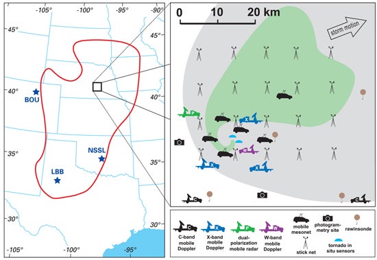
 The VORTEX2 study area (left), shown as a red loop, stretches some 900 miles from north to south across the Great Plains. Shown at right is a supercell thunderstorm surrounded by VORTEX2 observing teams. The heaviest precipitation, in green, loops around the target area where a tornado might occur. (Image courtesy VORTEX2.) News media terms of use*
The radar fleet for VORTEX2, including 10 mobile radars, will track winds and precipitation in and near tornadoes in unprecedented detail. The instruments will have a resolution as fine as 100 feet and time steps as small as 10 seconds. More than three dozen portable surface weather stations can blanket the area in and near a target storm. A robotic 12-foot propeller aircraft will probe the edges of severe storms.
The study area spans more than 900 miles, stretching from West Texas to southwestern Minnesota. On each day of operations, VORTEX2 teams will position equipment about an hour ahead of a potentially tornadic storm and remain in place until the storm passes. With no home base, the scientists remain on the road during the entire six-week study.
Meteorologists will provide detailed forecasts on short-fuse weather events as each day unfolds, using tools such as the Weather Research and Forecasting computer model, which proved its value during the 2009 campaign. WRF, pronounced "worf," was developed by NOAA, NCAR, and partners.
About half of the participants in the field will be undergraduate and graduate students. This is an unusually high percentage for a major field campaign and will provide a special learning experience for young researchers.