Active summer ahead for hurricanes—and researchers
May 17, 2010 - by Staff
Temporary impacts to NSF NCAR Road, Parking Lot and Trails
View more information.May 17, 2010 - by Staff
David Hosansky | 17 May 2010 • It’s been a difficult and sometimes tragic few months of weather events—first the snowstorms and record cold that battered much of the Northern Hemisphere and, more recently, tornadoes and floods here in the United States. Can we look forward to much peace in our atmosphere this summer?
The answer is most likely no, if the increasingly ominous temperature readings in the Atlantic are any guide.
Check out the National Hurricane Center’s map of water temperatures, below. You’ll notice a lot of orange, the kind of color associated with stormy weather. Warm waters are typical as we come out of an El Niño, but this time the sea surface temperatures in the eastern Atlantic (the birthplace of the infamous Cape Verde hurricanes) are at all-time records for this time of year—and, everything else being equal, warm waters fuel hurricanes.
As a result, seasonal forecasters are starting to warn of an unusually active hurricane season this summer.
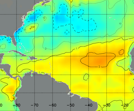
This map of sea-surface temperature anomalies for the week ending 15 May 2010 shows readings more than 1°C to 2°C (1.8–3.6°F) above average for this time of year over much of the eastern tropical Atlantic, where hurricanes may form later this year. (Courtesy NOAA Tropical Prediction Center.)
To be sure, such seasonal forecasts remain a work in progress. And, while we’ve made great strides in predicting the behavior of hurricanes—or typhoons or tropical cyclones, as these storms are known in other parts of the world—forecasters still struggle to predict when a disorganized system of thunderstorms over the ocean will coalesce into a hurricane. Even once a hurricane forms, it remains very challenging to anticipate fluctuations in intensity.
With these challenges in mind, NCAR is gearing up for a major research push this summer to learn more about hurricanes—and, ultimately, to improve forecasts.
This August, NCAR senior scientists Chris Davis and Andy Heymsfield will gather in St. Croix with colleagues from several universities for a major field project known as PREDICT (Pre-depression Investigation of Cloud Systems in the Tropics.) They will send the NSF/NCAR Gulfstream V research jet, aka HIAPER, into rough air to try to determine why some complexes of tropical thunderstorms build up into tropical depressions and storms, while others dissipate—a question that has been called one of the great remaining mysteries of the tropical atmosphere.
The scientists will be hunting for what are known as “sweet spots.” These are local regions in the lower atmosphere that are favorable for hurricane development because they are protected from such influences as dry air and unfavorable upper-level winds that take the punch out of a gathering storm.
“This is a priority for hurricane research,” explains Davis, a principal investigator on the project. “We need to anticipate hurricane formation in order to prepare for possible hazards that can develop several days later.”
NCAR is also working with NASA and NOAA this summer to piece together unusually detailed pictures of hurricanes from the inside. A robotic Northrop Grumman RQ-4 Global Hawk aircraft, owned by NASA, will fly over hurricanes and drop dozens of measuring devices, called sondes, to gather information on winds, temperatures, and other atmospheric variables inside the storms.
Also this summer, NCAR will run its Advanced Hurricane-research WRF (Weather Research and Forecasting) computer model to produce five-day forecasts of tropical storms and hurricanes. Researchers will evaluate the model’s strengths and weaknesses, hoping to use what they learn to help hurricane forecasters make improvements to their own models.
As we come to understand more about these massive storms and how environmental factors can affect them, scientists may also achieve a longer-term goal: determining understanding how hurricanes may change in coming decades.
NCAR is working with federal agencies and universities, as well as the insurance and energy industries, to use a combination of global climate and regional weather models to look at future hurricane activity in unprecedented detail. Researchers are targeting the hurricane-prone Gulf of Mexico and the Caribbean Sea to assess how our warming climate may affect the frequency, intensity, and location of hurricanes between now and the middle of the century.
Greg Holland, a senior scientist and NCAR associate director, is overseeing the initiative. “Our goal is to better inform coastal communities and government and industry leaders about the likelihood of future hurricane activity,” he explains. "Given our increasingly dense coastal development and our dependence on oil facilities in and around the Gulf of Mexico, we are dangerously vulnerable to hurricanes."