Is La Niña waiting in the wings?
May 24, 2010 - by Staff
May 24, 2010 - by Staff
Bob Henson | 25 May 2010 • Official monitoring groups aren’t quite ready to make the call, but it looks as if a newborn La Niña might steal the spotlight from a dying El Niño in the eastern tropical Pacific. Almost half of El Niños are followed by a La Niña, so it’d be no shock if this happened—but it’s not yet a done deal. As NOAA researcher Klaus Wolter noted on 3 May, "The jury is still out on whether we will see a switch to La Niña conditions in 2010."
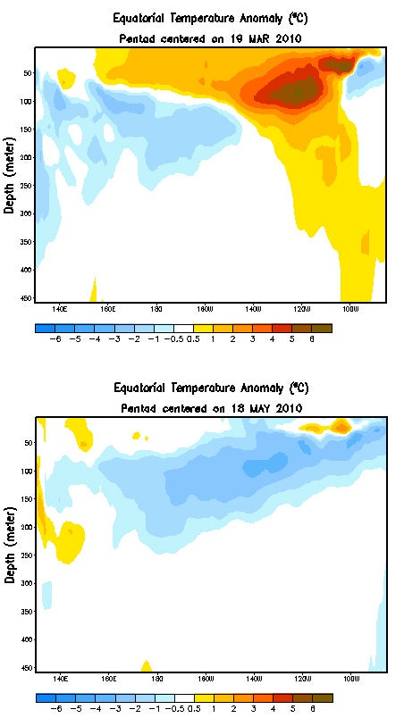 These maps, drawn from a NOAA animation, show where the Pacific Ocean's water temperatures are warmer (orange) or cooler (blue) than average in a cross section below the Equator. Warm anomalies associated with El Niño in March (top) had virtually disappeared by May (bottom). (Courtesy NOAA Climate Prediction Center.)
Both phenomena are part of the the El Niño–Southern Oscillation (ENSO), driven by periodic shifts in ocean and atmosphere circulation along the vast breadth of the tropical Pacific. The difference between El Niño and La Niña can be a huge one for U.S. weather and for global climate. A strong El Niño can nudge global temperatures upward by several tenths of a degree Fahrenheit for up to a year. This happened in 1998, when average global readings hit a new high after the 1997–98 El Niño. Similarly, the latest El Niño has done its bit to help make 2010 thus far the warmest year on record, according to NOAA and NASA data. (Back in December, the UK Met Office predicted this might happen.)
As for La Niña, it's strongly correlated with enhanced Atlantic hurricane activity. Combined with the record-setting warm waters already in place across the deep North Atlantic tropics, the arrival of a La Niña this year could lead to a setup as ominous as in 2005, the year that exhausted the storm-naming alphabet and rewrote the annals of Atlantic hurricane history.
NOAA’s depiction of sea surface temperatures below the Equator speaks volumes about the rapid demise of El Niño. As shown at right, the "positive anomalies" (warmer-than-usual waters) associated with El Niño’s warmth in March have almost completely vanished, replaced by negative (colder) anomalies typical of a developing La Niña. The shift is vivid on this NOAA animation.
Despite the dramatic change, forecasting centers remain cautious. On 12 May, the Australian Bureau of Meteorology agreed that the 2009–10 El Niño is history, adding:
The majority of climate model predictions suggest the tropical Pacific will cool further during the coming months, with the possible development of La Niña conditions by [the Southern Hemisphere’s] late winter or spring.
As of 20 May, the International Research Institute for Climate and Society (IRI) pegged the odds of a La Niña later this year at close to 40%. The various models surveyed by IRI appear to be split between predicting "neutral" (average) and La Niña conditions. Interestingly, the neutral camp is made up mostly of statistical models—those that project current events based on historical analogs—while those calling for a La Niña are mostly newer dynamical models that simulate the future more directly.
On 24 May, as the cool anomalies continued to build in the eastern Pacific, NOAA chimed in:
Although many models predict ENSO-neutral conditions, there is a growing possibility of La Niña developing during the second half of 2010.
NOAA's own model, the coupled forecast system ensemble (CFS), has thrown its weight behind La Niña. In its 23 May run, all members of the ensemble bring temperatures in the Niño3.4 region below average from June through the rest of 2010 (see graphic at bottom). Many of the ensemble members make the region cold enough to qualify as a La Niña.
It may yet be premature to welcome a 2010–11 La Niña into the world. We’re now crossing the "spring predictability barrier," when transitions are the most frequent and the toughest to predict. Both El Niño and La Niña tend to wax and wane in sync with the northern academic year; they often develop in the autumn, peak in the winter, and dissipate the next spring. Sometimes an event straddles two years, and often there’s a year or two of neutral conditions in between one event and the next. The result is a semiperiodic hodgepodge that has cyclic characteristics but is hardly as regular as a pendulum. Within a few weeks, though, we should have a better sense of whether La Niña is truly on the way.
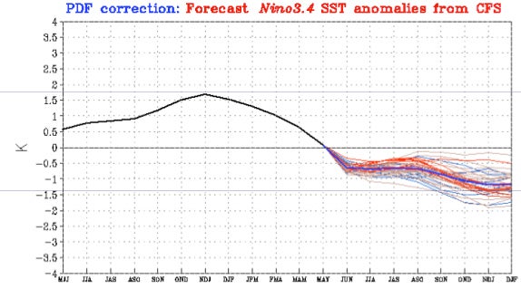 The 23 May output from NOAA's coupled forecast system (CFS), which links ocean and atmosphere, depicts a transition toward cooler-than-average waters across the Niño3.4 region of the eastern tropical Pacific. (Courtesy NOAA Climate Prediction Center.)