The hole story
Fortuitous data help unravel the decades-old mystery behind a puzzling cloud feature
Jun 10, 2010 - by Staff
Temporary impacts to NSF NCAR Road, Parking Lot and Trails
View more information.Jun 10, 2010 - by Staff
10 June 2010 • They’ve been called “crop circles in the sky.” Across the world, sightings of oddly circular holes within cloud layers—dubbed hole-punch clouds by scientists—have triggered bemusement and speculation. “A Halo over Moscow” was the headline of a front-page feature on Yahoo! after photos emerged of just such a cloud in October 2009. Some UFO followers reportedly called it “a true mystery,” while others likened it to an alien mothership, as in the film Independence Day.
Now, thanks to an unrelated field project, an NCAR scientist has become the first to link the paths of turboprop aircraft to light snowfall at the surface and a hole-punch cloud aloft. Appearing in the June issue of the Bulletin of the American Meteorological Society, the study could lead to a more comprehensive explanation on what causes the cloud feature under various conditions.
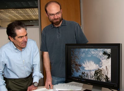 NCAR’s Andrew Heymsfield and Aaron Bansemer scrutinize a unusually circular and persistent hole-punch cloud photographed by broadcast meteorologist Alan Sealls on 11 December 2003 above Mobile, Alabama.
“The data just fell in my lap,” says NCAR cloud physicist Andrew Heymsfield. He authored the BAMS paper with Patrick Kennedy (Colorado State University), Steven Massie and Carl Schmitt (NCAR), Zhien Wang and Samuel Haimov (University of Wyoming), and Art Rangno (retired, University of Washington).
The synchronicity occurred through Kennedy’s role in the ICE-L project (Ice in Clouds Experiment–Layer Clouds). The study’s main goal is to determine whether measurements of ice nuclei can be used to predict the number of ice particles that actually form. Even when nuclei are scarce, ice crystals can form directly from supercooled water at temperatures well below freezing if conditions are right—and hole-punch clouds appear to be one example.
On 11 December 2007, Kennedy noticed a linear radar echo that he assumed was a narrow snow band. Months later, Kennedy was preparing a poster for an ICE-L workshop at NCAR when he looked more closely at the data from 11 December. “It became apparent that the echo had evolved in a unique way, but I had no satisfactory explanation,” says Kennedy. Though he felt “some degree of trepidation” when he presented his findings at the workshop, he and Heysmfield would soon decipher the mystery.
Flight tracks for the C-130 revealed that the plane had apparently flown through the echo. Heymsfield and Kennedy went back through data from the aircraft’s forward- and downward-viewing camera. They noticed a gap in an otherwise-solid deck of altocumulus clouds in the forward imagery, as well as a band of snow that extended to the ground.
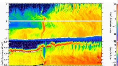 Reflectivity from the Wyoming Cloud Radar, looking upward (top) and downward (middle), shows the hole left behind by precipitation detected near the ground from the Wyoming Cloud Lidar (bottom). (Image courtesy Andrew Heymsfield.)
Once the C-130 was directly below the hole, it had encountered a burst of precipitation that extended to ground level, and a long, narrow echo appeared on radar. Since the hole was oriented along the same direction as the standard flight tracks of commercial aircraft in the region, Heymsfield surmised that a plane flying through the cloud might have somehow caused ice particles to form and “snow out” along its path, leaving a canal-shaped hole-punch cloud behind.
The hunch wasn’t a far-fetched one. As far back as the 1940s, scientists have reported on hole-punch clouds and suspected that aircraft were the culprits. Weatherwise magazine covered “Hole-in-Cloud: A Meteorological Whodunit?” in 1968. Readers speculated on an array of possible aviation-related causes, from acoustic shock waves produced by jets to local warming of the air along a jet’s path and the formation of ice along jet contrails.
There haven’t been enough data to confirm any of these hypotheses until Heymsfield’s study. As it turns out, the 2007 event in Colorado was apparently caused not by a jet but by a turboprop aircraft. In the 1980s, Rangno teamed up with UW colleague Peter Hobbs to report on aircraft-produced ice particles, or APIPs, resulting from turboprop aircraft. They linked the phenomenon to rapid expansion and cooling of air near the tips of aircraft propellers spinning in flight, with the sudden cooling helping freeze supercooled water droplets into ice particles.
From all the clues at hand, it appears this is what happened in the Colorado case, says Heymsfield. Lidar data revealed that the cloud was composed of liquid water. A review of FAA flight tracks indicated that two turboprop planes operated by Mesa and Big Sky Airlines flew close to the hole-punch location, and along the same line as the snow band, within 10 minutes of each other. “We think these aircraft could have easily generated APIPs as they ascended,” says Heymsfield.
The case is bolstered by data from spectrometers aboard the C-130 that profiled the snowflakes within the precipitation burst beneath the hole punch. These plate-shaped crystals—some larger than a millimeter—showed evidence of riming (accumulations of liquid water), whereas ice particles elsewhere in the cloud showed little or no riming. “This tells us that the aircraft literally seeded the cloud just by flying through it,” Heymsfield says.
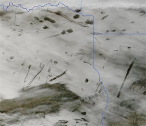 NASA’s Moderate Resolution Imaging Spectroradiometer captured an array of hole-punch clouds above Texas, Louisiana, and Arkansas on 29 January 2007. (Image courtesy NASA Earth Observatory and Jeff Schmaltz).
Although hole-punch clouds themselves aren’t new, the BAMS study might clear up misconceptions among the public as well as scientists. “These clouds are probably fairly ubiquitous, but there are only a few situations where you can see them from above or below,” says Heysmfield. Given the large number of turboprops flying over Europe, where cloud decks with supercooled water are frequent, “I see no reason why these things aren’t producing precipitation on the ground.”
There’s no comparable data set yet for a jet-induced hole-punch cloud, but Heysmfield believes such clouds could result from air expanding over the wings of jets and cooling locally by as much as 20°C (36°F). He hopes to use more satellite imagery to collect a larger set of examples that might be linked to a broad range of aircraft and weather conditions. As he puts it, “It just takes some supercooled water at the right temperature.”