Inside the sauna: A look at our sultry summer
Jul 23, 2010 - by Staff
Temporary impacts to NSF NCAR Road, Parking Lot and Trails
View more information.Jul 23, 2010 - by Staff
Bob Henson | 23 July 2010 • Hitting a dip in the road is one thing, but losing your vehicle in a 40-foot-wide sinkhole is quite another. That’s what happened to the unlucky driver of a Cadillac Escalade in downtown Milwaukee on Thursday, 22 July. The sinkhole opened amidst a deluge that closed the city’s main airport, where the 24-hour rainfall total (5.79”) was the second-highest on record.
To get rain like this, you need lots of moisture in the air, and there’s been no lack of that across much of the central and eastern United States this summer. Conditions have been strikingly humid from the central and southern Great Plains to the East Coast. In Kansas City and Tulsa, overnight lows have seldom dipped much below 80°F, with consistently oppressive humidity.
Pulses of tropical air flowing north and east from the Gulf of Mexico are largely to blame, injecting unusual amounts of moisture into the central and eastern United States. One might think humidity is measured only at the ground, but meteorologists also look at precipitable water—the total amount of water vapor in the atmosphere above a point. On Friday morning, 23 July, the precipitable water measured by a balloon-borne radiosonde (instrument package) above Buffalo, New York, was 2.24 inches—one of the highest values on record, according to a forecast discussion issued that day by the National Weather Service office in Buffalo. Earlier this month, Omaha measured 2.39 inches of precipitable water, the highest value there in at least a decade (see graphic). Where air converges and rises—near a front, for example—rainfall totals can be far greater than the value of precipitable water.
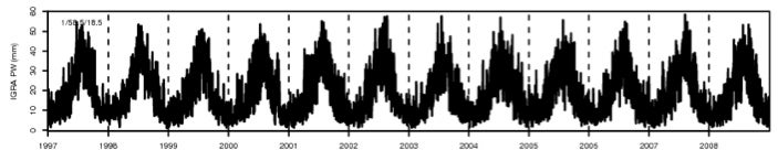 The amount of water vapor in the atmosphere above Omaha, Nebraska, is depicted in this trace of precipitable water as measured from 1997 through 2008. On 4 July 2010, Omaha reported 2.39 inches (6.07 centimeters) of precipitable water—a value that would extend just off the top of this chart. (Graphic courtesy Junhong Wang, NCAR/EOL.)
Part of this summer’s steaminess is due to lush vegetation. Just as they do in a tropical rainforest, an abundance of trees and other plants has been intercepting and collecting heavy rain. Much of the water is then re-evaporated into the atmosphere, helping provide fuel for more rain. After a long dry period, grasses and trees typically dry out, pinching off this feedback cycle, but across much of the country this hasn’t happened yet.
All that moisture tends to tamp down daily temperature ranges. When humidity is high, the mercury may stay below record levels by day but remain unusually warm at night. What’s especially rare is for such sultry weather to linger for weeks on end, as it has in places from the Midwest to the Mid-Atlantic. Several states and cities, including Miami and Washington, D.C., saw their hottest June ever recorded.
In many locations, the swelter continues. As of Thursday, 22 July, New York’s Central Park—where records extend back to 1868—has recorded an average temperature for the month of 81.8°F, well above the previous July record of 81.4°F set in 1999. With a scorching weekend in store, Manhattan has a good chance of notching its warmest-ever July, and Washington’s National Airport is also on track for a July record.
![]()
An experimental version of the atmospheric component of NCAR's Community Climate System Model produced this depiction of precipitable water as part of a long-term climate simulation. A full year of simulated climate is shown. (Animation by NCAR/CISL Visualization & Technology Section.)
The heat has drawn moisture out of the ground, parching lawns and trees in the New York City area, and this month has brought Central Park less than half its usual amount of rain this far. But the air hasn’t felt dry—in fact, for most of the month it’s actually been quite muggy in the Big Apple. One sign of this is the unusually warm overnight lows. Only three days in July have set record highs in Central Park, but as of this weekend, the city will have gone three full weeks without once dipping to 70°F.
Hot weather and record-setting rains are both elements of a changing climate. The basic processes are well understood: adding more heat increases evaporation, providing more moisture to fuel rain and snowstorms, so that when it does rain or snow, it can really pour. Observations have been bearing this out in many locations around the globe, as noted by the Intergovernmental Panel on Climate Change in its 2007 assessment report.
As the long-suffering denizens of the mid-Atlantic look back—perhaps longingly, given the heat they’re enduring—to the record snowfalls of the past winter, it’s worth remembering that a warmer globe can deliver both deeper snows and heavier deluges.