Can scientists predict a wildfire’s spread?
Oct 26, 2010 - by Staff
Temporary impacts to NSF NCAR Road, Parking Lot and Trails
View more information.Oct 26, 2010 - by Staff
David Hosansky | 26 October 2010 • A new computer simulation shows how far researchers have come in their quest to better understand the dynamics of wildfires.
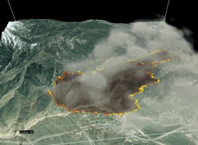
This still is from a computer simulation of the 2006 Esperanza Fire in California. To view the animation, click here. (Visualization by researchers at NCAR, USDA Forest Service Riverside Fire Laboratory, and University of California at Santa Barbara.)
The data-driven simulation recreates the 2006 Esperanza Fire, a fast-spreading conflagration that killed five firefighters during a southern California Santa Ana wind event. The research is a team effort by NCAR meteorologist Janice Coen and colleagues from the USDA Forest Service and the University of California at Santa Barbara, visualized with an NCAR software tool known as VAPOR.
The researchers have successfully captured a number of fine-scale details, including:
Can such simulations eventually help scientists make predictions about wildfires?
Wildfires are dangerous partly because of the seemingly random way they spread. The flames are often uncontrollable, whipped by fast-shifting gusts of winds and unexpectedly flaring over fire lines to reach dry brush and trees. Factor in the usual uncertainties in weather prediction, and it can seem impossible to anticipate a fire’s movements.
Authorities, erring on the side of safety, sometimes evacuate entire communities because the flames can take an unexpected turn. But there isn’t always time to get everyone out of harm’s way.
During Australia’s 2009 Black Saturday fires, winds of 45 mph (72 km/h) drove the Kilmore East Fire southeast for 30 miles in six hours before a 90-degree wind change turned the side of the fire into a 30-mile long flaming front headed right for the town of Kinglake—a disaster that killed 119 people. Even experienced firefighters can find themselves trapped, as happened with the Esperanza Fire and the 1994 South Canyon Fire on Storm King Mountain in Colorado that killed 14 firefighters.
Accurately and reliably forecasting how fires will unfold would represent quite an accomplishment, and Coen cautions that much work still needs to be done. Wildfires are notoriously complex. They are driven by a sometimes bewildering combination of factors, especially weather conditions, such as winds and humidity; the mix and condition of vegetation; and terrain. Sustained winds, low humidity, and steep ravines covered in chaparral present firefighters with one set of conditions; rolling hillsides covered with pine forests in weak afternoon upslope winds present them with something else entirely.
As a meteorologist, Coen works to connect events in the atmosphere with the movements of a fire—for example, the downbursts that can fan the flames and the release of heat that creates fire-generated pyrocumulus clouds, leading to shifts of winds by the fire.
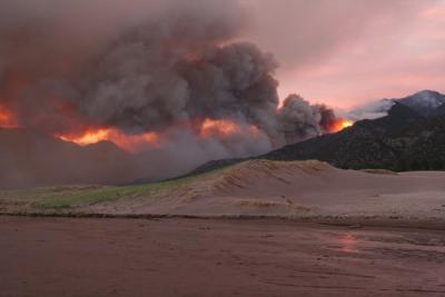
The 2010 Medano Fire burned more than 6,000 acres in Sand Dunes National Park, Colorado. The blaze, started by a lightning strike, caused relatively little damage. (Photo by David Hosansky, UCAR.)
To more accurately recreate the large wildfires that can threaten whole communities, Coen’s simulations include large-scale atmospheric events. These may include the passage of fronts or, in southern California, the vertical movements of air over mountains that bring strong Santa Ana winds down to ground level, accelerating the spread of a fire.
“Once you pull back from the details of flames and begin looking at a megafire as a weather phenomenon you see the unfolding of the event in an entirely different way,” Coen explains.
“You need to consider the rules governing the motion of fluids like air and the forces that air and fire are exerting on each other to understand where a fire went and what it did. Understanding fire’s complexity can help answer frustrated homeowners’ questions about why the fire reached one specific structure but not another.”
Coen’s next test is to simulate a fire event faster than it occurs in real time, projecting where the blaze will spread and how quickly it will grow for the next several days. Such a projection would rely on her computer model—which runs on NCAR’s supercomputer and incorporates local weather conditions, ground vegetation, and topography—as well as aerial maps of the blaze and input from fire teams. If she and her colleagues an successfully simulate where the fire spreads and the intensity of the fire, they can work toward projecting fires on a more regular basis.
In time, these simulations could be very helpful to firefighting crews, providing them with another piece of information to support their difficult decisions.