Never in doubt
Nov 2, 2010 - by Staff
Temporary impacts to NSF NCAR Road, Parking Lot and Trails
View more information.Nov 2, 2010 - by Staff
2 November 2010 • It’s midday Sunday, 29 August. Labor Day weekend—the last East Coast beach holiday of the summer of 2010—begins in five days. An intensifying tropical storm is passing the Leeward Islands and heading toward the open waters north of Puerto Rico, with a huge stretch of unusually warm water ahead of it and a strong Bermuda High to the north, guiding the storm toward the west-northwest.
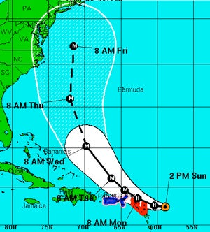
Figure 1. The official five-day forecast track of Hurricane Earl issued by NOAA’s National Weather Service as of 2:00 p.m. EDT on 29 August 2010.
The media speculate about the storm possibly hitting the popular North Carolina beaches later in the week, perhaps ruining the Labor Day weekend at best and causing massive destruction and loss of life at worst. But the long-range numerical weather forecast models for Hurricane Earl are consistent and nearly unanimous in forecasting the storm to gradually turn toward the northwest, north, and then northeast, brushing the coast with gusty winds, high surf, and rain, but missing landfall by a couple hundred miles. These models, which have become an increasingly reliable tool for the official hurricane forecasters in the National Weather Service, provide the basis for predictions that deliver a reassuring message to the worried public (see Figure 1).
Some commentators, perhaps remembering storms and forecasts from long ago, tell the public that hurricane are fickle and unpredictable. Yet the science-based models continue to forecast the turning of Earl’s path and minimal impacts on the coast. As the week progresses and the forecasts remain consistent, few people cancel their weekend plans and even fewer leave the coastal areas early, thus avoiding enormous economic losses to coastal businesses over the holiday weekend.
By Wednesday morning, Earl has intensified to a Category 4 hurricane, one category short of the most intense. It is on a heading that ominously points toward the North Carolina coast, and a simple extrapolation of the current movement would carry it directly onto the coast in about 48 hours. Yet still the models, and the official forecasts, stick by their story: Earl will turn away from the coast and spare it from major impacts. Doubtless there are many members of the public—and probably some forecasters, too—biting their nails, wondering if the models are going to prove correct. As a precaution, the National Hurricane Center issues a hurricane watch for parts of North Carolina, Virgina, and Delaware, as well as southeast Massachusetts. However, the model consistency allows NHC to spare the heavily populated coastlines of New Jersey, New York, Connecticut, and Rhode Island from the expense and anxiety of hurricane watches and warnings.
On Friday morning, 3 September, Hurricane Earl has followed the forecast trajectory and is located off the coast of North Carolina, but it is now heading toward the northeast. A well-forecasted middle-latitude trough in the jet stream, moving in from the west, has arrived over the eastern United States, and the increased wind shear (also correctly predicted) has weakened Earl and steered it out to sea. Only three Americans and one Canadian are killed as a direct result of Earl, and U.S. damages are expected to run below $100 million—a smaller total than the economic hit associated with a single large hurricane watch.
Unsung benefits
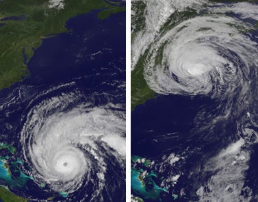
Left: Hurricane Earl approaches the Bahamas on Wednesday, 1 September. Right: Earl recurves just east of the U.S. East Coast on Friday, 3 September. (Satellite images courtesy NOAA/NASA GOES Project.)
The excellent model projections and official forecasts for Earl saved many thousands of people from unnecessary preparations and evacuations, including tourists who might have cancelled their plans in the days of less accurate and reliable forecasts. Had Earl threatened the East Coast 30 years ago, without the consistent guidance of modern numerical models, forecasters would have likely erred more on the side of caution and issued much stronger warnings and advice to the public. The perceived “fickleness” of hurricanes would have carried the day, and massive evacuations and expensive preparations would have occurred. The economic savings associated with good forecasts of storms that narrowly miss making landfall are often underemphasized next to the benefits of adequately warning people about storms that do arrive.
As a young scientist in the late 1960s, I was working in NOAA’s National Hurricane Research Laboratory under the direction of Cecil Gentry and my boss, Stan Rosenthal. I was working on a very early version of a three-dimensional hurricane model, one that was eventually to become the Penn State–NCAR Mesoscale Model (MM) series, leading to one of the most widely used community mesoscale models in the world (MM5). At the time, however, this was purely a research model, and I sensed from frequent discussions with the NHC forecasters—who were one floor above our research lab in Coral Gables—that they were not holding their breath waiting for its eventual applicability to real forecasts. Instead, the team relied mainly on statistical models and synoptic experience, and it did an excellent job given the lack of satellite observations and model guidance that we now have (and perhaps take for granted). However, Bob Simpson, NHC’s director at the time, already saw the potential of dynamic hurricane models initialized with observations. He funded one of my first research projects when I moved to Penn State in 1971: a proposal to develop a data assimilation procedure for the hurricane model.
Unlike the skillful prediction of high-impact storms such as Hurricane Katrina, the high-quality forecasts for Earl will soon be forgotten. However, their benefits for our economy and society are large, and they should be considered next to the costs of the observing and modeling systems that make such forecasts possible.
The good forecasts of Hurricane Earl were not unusual, as the accuracy of hurricane track forecasts has increased steadily over the years. As seen in Figure 2 (below), a three-day forecast of hurricane track is as accurate as a two-day forecast only 10 years ago. Even the five-day track forecasts, which began in 2001, are more skillful than three-day forecasts from the 1980s.
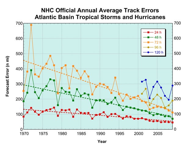
Figure 2. The increasing accuracy of the NHC’s official track forecasts for Atlantic hurricanes. (Courtesy Lauren Morone, NWS.)
The ingredients of a better forecast
How do computer models capture the motion of storms like Hurricane Earl so well, and why are the models improving so steadily over time? Hurricanes are natural phenomena that grow, decay, and move according to well-known physical laws; they are not mysterious beings with a capricious will of their own. Hence they are predictable far in advance with numerical models if the models are provided with the proper specification of the initial state of the atmosphere and include appropriate representations of physical processes such as radiation, condensation and evaporation, and the exchange of heat, water vapor, and momentum at Earth’s surface.
Three elements in particular have led to improved model-based hurricane forecasts. These include
Forty years ago we had none of these. Twenty-five years ago we were in the early stages of realizing the potential of all three elements. Today, thanks to public investments in observing systems, models, computers, and research, we are entering a relatively mature stage, where the paradigm is proven every day and the value of all the investments to the taxpayers is justified many times over.
A caution: this story is optimistic, and justifiably so. However, there are still gaps in observations and errors in the models, and assimilation techniques are still undergoing improvement. And some atmospheric circulation patterns are more predictable than others. People in threatened areas must thus remain alert of potential weather threats even as they rely on the official NWS forecasts and warnings. Experienced and well-trained forecasters are able to recognize when the models are reliable (which is most of the time) and when the models diverge and more significant uncertainties are present.
My vision is that as long as the U.S. and other nations continue to invest in the ingredients of skilled prediction—global observing systems, research on numerical models, computers to run them, and ways to incorporate the observations into the models for maximum benefit—we will continue to see significant advances in 3- to 10-day forecasts. This will provide society with earlier and better guidance on the severe weather events that remain most difficult to predict, as well as systems like Hurricane Earl, the storm that was “never in doubt.”