Where it's wintry and where it's not: La Niña at the helm
Nov 23, 2010 - by Staff
Temporary impacts to NSF NCAR Road, Parking Lot and Trails
View more information.Nov 23, 2010 - by Staff
Bob Henson | 23 November 2010 • If you’re looking for cold, stormy weather this Thanksgiving week, head northwest. The northern Rockies and Pacific Northwest are getting pummeled with one of their most intense winter storms in years. This morning, blizzard warnings stretched from Colorado to Washington. Last Sunday night in Seattle, temperatures sank below freezing, with bitter winds to boot—and the city may not top 32°F again till Thanksgiving arrives on Thursday, 25 November. [UPDATE: Seattle cracked freezing and hit 39°F on Thanksgiving Day.]
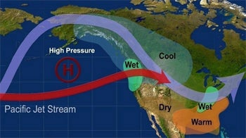
This graphic shows the temperature and precipitation anomalies and jet-stream locations typical during La Niña winters. (Courtesy NOAA.)
This pattern is right in line with what you’d expect from a healthy La Niña, now in place across the equatorial Pacific (see NOAA’s weekly update in PDF form). As shown on the map at right, the northwestern U.S. tends toward above-average precipitation and below-average temperature when a La Niña is under way.
Conversely, the Sun Belt is often drier than normal. That’s the case now, especially in the Southwest, where Phoenix has gone more than a month without measurable rain (though a few showers fell nearby on Sunday), and in Florida, where drought is intensifying. In addition, the Mississippi and Ohio valleys are struggling with drought right now. However, if La Niña is true to form, there’ll be an increasing chance of heavier-than-usual rain and snow in that part of the Midwest by midwinter.
There’s actually widespread rain in the U.S. right now, but in a very rare place. As the La Niña-boosted jet stream pushes north into Alaska, it’s driving an unusually warm and moist air mass into the state, riding atop cold surface air. The result is the heaviest late-autumn deluge ever seen in interior Alaska, with ice glazing much of the state in places that would normally be getting rounds of snow and temperatures dipping below 0°F most nights.
“We haven’t ever seen anything like this in the interior,” hydrologist Ed Plumb (National Weather Service/Fairbanks) told the Fairbanks Daily News-Miner.
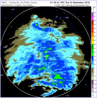
It’s beginning to look a bit like summer in parts of central Alaska. This radar image for 23 November shows widespread precipitation. Where temperatures aloft are above freezing—from Fairbanks (center of image) toward the south and west—that precipitation is falling as rain. (Courtesy NCAR/RAL Real-Time Weather Data.)
As of midday Tuesday, 23 November, Fairbanks had notched 0.73”, making it their rainiest November storm on record. If the total reaches one inch, which appears quite possible, it’ll be the wettest period ever recorded in the November–March window. The only rival is the 0.99” recorded on January 20, 1937—more than 20 years before Alaska became a state. [UPDATE: Fairbanks ended up just short of the 1937 record with a storm total of 0.95”.]