Boulder’s tempestuous temperatures
Dec 2, 2010 - by Staff
Temporary impacts to NSF NCAR Road, Parking Lot and Trails
View more information.Dec 2, 2010 - by Staff
Margaret LeMone | 3 December 2010 • It was pleasant walking to church in Boulder on the morning of Sunday, 21 November. The minister even commented on how it seemed like an early fall day. As we walked home, we enjoyed mild late-autumn temperatures in the 40s Fahrenheit and nearly calm winds. Sparrows were chirping overhead.
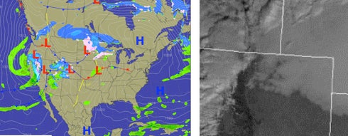
Left: The national weather map for 5:00 a.m. MST (noon UTC) on Sunday, 21 November. Right: The satellite image for 9:00 a.m. MST clearly showed a deck of thick clouds covering the northeast corner of Colorado, extending toward Boulder. The leading edge of this cloud deck swept into Boulder that morning. (Courtesy NCAR/RAL Real-Time Weather Data.)
Things changed in a hurry, though. As we turned north, I saw a stirring in the leaves ahead of us – and then it hit. Suddenly there was a cold northeast wind. We stopped so that my husband could put on his gloves. As we continued to walk north and then northeast up onto the mesa where our house sits, the wind felt cold. We thought it might be an upslope wind related to a mountain wave, but we weren’t sure. All we knew was that it was much colder, and we started to wonder if a front had passed. The skies were clear overhead, but there were ragged clouds to the north and other clouds over the mountains to the west.
At home, once I had changed clothes and started laundry, I decided to check the weather online. I quickly discovered that the sharp temperature drop wasn’t our imagination: what we had seen was a strong frontal passage. Overnight, temperatures at NCAR’s Foothills Laboratory (about two miles to our east) had jumped from the 20s to the upper 40s in only a few minutes as winds swung around to the west (a warming, downslope flow). But during our morning walk, as winds shifted from light southerly to northerly, temperatures fell back from 47°F to 32°F almost instantly. This was followed by a further drop over a few more minutes to the upper 20s (see temperature trace at bottom). Turning to the surface analysis from 5:00 a.m. MST (1200 UTC), I noticed a front in the vicinity of Boulder and Denver (see map at right).
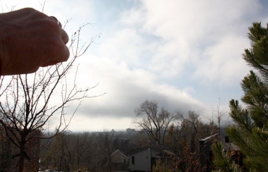
I took this photo of frontal clouds while looking to the south. The leading edge of the clouds is near the horizon. My fist blocks the sun.
At that point, I looked out the window to the east (computer first, window second!), and discovered the skies were now filled with the same type of ragged cumuliform clouds we had seen moving in just a few minutes earlier. Going outside to get a few pictures, I discovered the clouds had rapidly moved southward, but I managed to catch the leading edge (see photo at left). Presumably it was still a mild and sunny morning just a few miles further south. In fact, the high temperature in Denver later that day reached 54°F.
When fronts are like this — cloudy on the north side, clear on the south side — they behave in interesting ways, as noted in my blog of 16 August. During the day, these fronts generally strengthen over time. This is because, near the surface, the cloud-shaded air on the north side of the front remains cool while air south of the front is heated by full sunlight. These twin effects help intensify the temperature contrast across the front from south to north. However, at night, the opposite occurs: clouds act to limit radiational cooling to the north, while clear skies allow strong cooling to the south. Together, these lead to a reduced north-south contrast across the front.
Here comes the chinook
Here in the West, downslope winds called chinooks (“snow-eaters”) also strengthen the temperature change across frontal boundaries. These winds are warmed by compression as they descend into lower elevations and higher air pressure. We get rapid warming when the chinook winds cause an arctic front to retreat.
As you can see in the temperature graphic below, the arrival of the chinook in Boulder—indicated by a shift of the wind from southerly to westerly—caused a temperature jump during the night almost as large as the one we experienced the following morning. Sometimes these events are even more extreme, especially in midwinter.
On 22 January 1943, an early-morning chinook in Spearfish, South Dakota, caused a temperature rise from –4 °F (–16°C) to 45° F (7 °C) in only two minutes – the fastest temperature change ever recorded in such a short period (here’s a graph taken from the recording thermometer at Spearfish). And Loma, Montana, holds the world record for the greatest temperature change in 24 hours. On 14–15 January 1972, a chinook warmed the town from –54° F (–48 °C) to 49° F (9 °C)—a change of an amazing 103°F! (Here's a complete writeup in PDF form.)
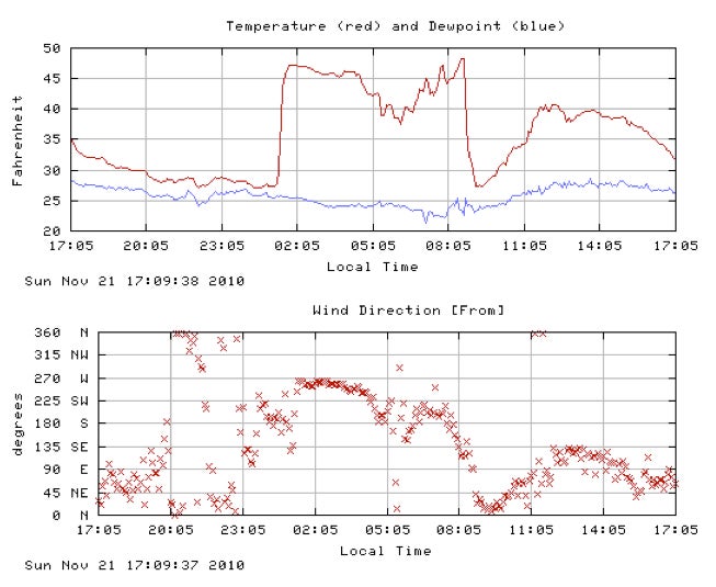
Temperature and wind direction as recorded at NCAR’s Foothills Laboratory from about 5 p.m. MST Saturday, 20 November, to Sunday, 21 November. (Courtesy NCAR/RAL Real-Time Weather Data.)