Radar’s next phase
Dual polarization holds promise for both research and weather forecasting
Mar 8, 2011 - by Staff
Temporary impacts to NSF NCAR Road, Parking Lot and Trails
View more information.Mar 8, 2011 - by Staff
Bob Henson | 11 March 2011 • The biggest upgrade to the U.S. weather-radar network in 15 years gets rolling this winter with a minimum of fanfare—debuting under the radar, as it were. But the new capabilities should get their fair share of attention in the long run.
By the time the improvements are completed in 2013, each of the 160 Doppler radars operated by the National Weather Service will be able to send and receive signals that are polarized in two directions. Eventually, the dual-pol data from NWS sites should help scientists analyze the fast-changing cloud physics and dynamics that hold some of meteorology’s greatest mysteries. The technology itself is an outgrowth of decades of research at NCAR, Colorado State University (CSU), NOAA’s National Severe Storms Laboratory (NSSL), and elsewhere.
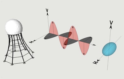
Dual-polarization radars send out signals in both horizontal and vertical orientation (gray and red areas above). The relative strength of returning signals provides clues to the shape of objects and allows scientists to infer precipitation type. (Image courtesy Atmospheric Radar Research Center.)
The dual polarization technique (or “dual-pol”) goes a big step beyond conventional radar, which measures the location and intensity of precipitation, and Doppler radar, which infers the speed of winds blowing toward or away from the radar. Now forecasters will be able to track subtleties in precipitation that can have huge impacts on public safety.
The advantage of dual-pol radar lies in its ability to analyze differences in the shapes of hydrometeors (rain, snow, sleet, and hail). Despite the whims of cartoonists, raindrops are shaped more like hamburger buns than teardrops, flattened by the air below them as they fall. This horizontal orientation means that a raindrop sends more energy back to a dual-pol radar in the horizontal dimension than in the vertical.
Hailstones are much more irregular in shape, but because they tumble as they fall, the nooks and crannies average out; to a dual-pol radar, hailstones appear round. Variations like these allow dual-pol to map out a growing array of objects in the sky.
“I think the biggest improvement that’s going to happen right away is in detecting winter-weather precipitation types,” says Paul Schlatter of NOAA’s Warning Decision Training Branch. Schlatter led the development of a dual-pol training course to be used by NWS meteorologists. Far more precisely than before, forecasters will be able to identify locations where rain is transitioning to snow or vice versa.
“Broadcasters will be able to say, ‘It’s changing to snow in this part of the metro area,’” Schlatter says. At any given spot, he adds, “we could have 30 to 60 minutes lead time on when that transition might occur, which can be really important.”
Dual-pol may also play a key role in tornado awareness, allowing NWS meteorologists to warn the public that a tornado is officially confirmed even when it’s rain-wrapped or otherwise unseen by spotters. Small bits of debris, such as shards of insulation, produce a distinct dual-pol signal. “This gives you confirmation that a tornado is occurring,” Schlatter notes.
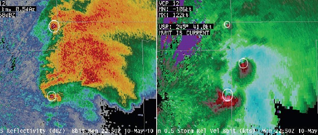
As a severe weather outbreak unfolded across Oklahoma on 10 May 2010, NSSL’s dual-pol radar confirmed the genesis of a tornado near Shawnee Lake (right image, center circle) while detecting debris lofted by two other tornadoes (left image, top and bottom circles).
Schlatter had an uneasy encounter with the technology’s prowess on 10 May 2010. As severe weather rampaged across Oklahoma, he watched dual-pol data from his National Weather Center office in Norman on a tornado that was seriously damaging his home a few miles away. “On one single image,” he says, “we were able to scan five separate debris signatures.”
Dusan Zrnić (NOAA National Severe Storms Laboratory) is a dual-polarization pioneer. (Image courtesy NSSL.)
After years of development, the concept of polarizing radar signals for meteorology took root in the fertile soil of Canada’s Prairie provinces. NSSL’s Richard Doviak and Dusan Zrnić traveled to Alberta in 1979 to check out a circularly polarized radar pioneered by McGill University. “Dick had been interested in doing polarization research as early as 1971, but NSSL was deeply immersed in Doppler work at the time,” recalls Zrnić.
Once the lab decided to build its own polarized radar, it went for a dual-pol approach, with signals oriented in the horizontal or vertical rather than circularly. “We made this choice for good reason,” says Zrnić. Research by Thomas Seliga and Viswanathan Bringi, then both at Ohio State University, had shown how signals from the two orientations might yield critical data on the character of precipitation.
This hypothesis was confirmed through measurements in a 1977 Oklahoma field project using the CHILL dual-pol radar under the leadership of Gene Mueller. Now based at CSU, CHILL—the first university-based dual-pol radar—was named after Chicago, Illinois, where it was launched by the University of Chicago and the Illinois State Water Survey. NCAR was another dual-pol pioneer, converting its CP-2 radar and creating the first real-time displays of differential reflectivity (relating horizontal to vertical returns).
Starting in the mid-1980s, Zrnić teamed with postdoctoral fellows Mangalore Sachidananda (now at the Indian Institute of Technology) and Narasimha Balakrishnan (now at the Indian Institute of Science) to work out the details of distinguishing rain from hail and other hydrometeors using dual-pol data, with contributions from Jerry Straka (University of Oklahoma). By 1996, Zrnić had written a paper for the Bulletin of the American Meteorological Society pondering the eventual role of dual-pol in operational settings.

Jothiram Vivekanandan played a leading role in the development of NCAR's S-Pol radar.
While it would take years to iron out the wrinkles of dual-pol for everyday use, the technology quickly made its way into field studies. In the mid-1980s, NCAR converted one of its existing cloud-physics radars to dual-pol, but scientists found that its usefulness for collaborative work was limited.
“Unless you have a good engineering background, you can’t interpret the raw data very easily. It was not that popular,” says NCAR’s Jothiram Vivekanandan. A breakthrough came in the early 1990s, when NSSL devised a technique for obtaining the major dual-pol products in real time. CSU and NCAR followed suit, which paved the way for more widespread use of dual-pol among researchers. Further progress came in 1998, when Anthony Holt (University of Essex) convinced CSU to run both of the CHILL transmitters—horizontal and vertical—at the same time, rather than alternating between the two modes. This simultaneous technique has been incorporated into the NWS dual-pol upgrade, where it meshes well with hardware requirements and existing software.
Dual-pol’s appeal to university scientists got a major boost with NCAR’s S-Pol, an NSF-funded community resource that debuted in 1996. This radar’s ingenious design allowed the entire mechanism to be packed into four shipping containers (seatainers); these can be arranged in a matter of days to form a pedestal for the radar with minimal impact on the landscape. “No one wants to have a big concrete pad in their backyard,” says Vivekanandan.
Managed by NCAR’s Tammy Weckwerth, S-Pol has played a lead role in 18 field projects around the world over the past 15 years (see photos). A high-frequency, dual-pol Ka-band radar appended to the unit transforms S-Pol into S-PolKa. This hybrid setup can detect fine-scale cloud droplets and gauge humidity and liquid water amounts.
NCAR's S-Pol radar traveled to Brazil in 1998 as part of NASA's Tropical Rainfall Measuring Mission. (Photo by Scott Ellis, NCAR.)
CSU’s Steven Rutledge has used S-Pol on four different projects, including the radar’s first campaign in 1997. “S-Pol has provided high-quality data from all of these projects, allowing my students, staff, and me to do some very interesting research,” he says. “Its high degree of portability and high data quality, and the excellent staff that come along with the radar, are real pluses.”
Two S-Pol deployments near mountain ranges—the Alps in 1999 and the Oregon Cascades in 2001—helped Robert Houze (University of Washington) examine how mountain barriers influence fronts. S-Pol tracked the evolution of ice particles created as air is forced up a mountain range, with the particles eventually melting out as rain. At both sites, the polarimetric and wind data revealed that this process boosted precipitation in both stable and unstable air, but through different mechanisms for the two kinds of air masses.
“S-Pol has been groundbreaking in this work,” says Houze. Later this year, he and Rutledge will be taking S-Pol to the Maldives to study how tropical clouds impact large-scale climate variations emanating from the tropics. The project is called DYNAMO (Dynamics of the Madden-Julian Oscillation).
While putting S-Pol on the road, NCAR has also teamed with NSSL on various improvements to the software that processes dual-pol signals. These innovations include a phase-coding algorithm that allows radars to capture usable signals from as far as 260 kilometers (160 miles), nearly twice as far as before.
Also at NCAR, John Hubbert led a team effort to better identify ground clutter—unwanted radar signals from buildings and other fixed objects—and distinguish it from weather data. The software was added to current NWS radars in 2009, and a dual-pol version will accompany the NWS upgrade.
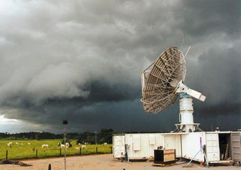
A dual-pol radar at NOAA’s National Severe Storms Laboratory in Norman, Oklahoma, monitored this storm during the 2003 Thunderstorm Electrification and Lightning Experiment. (Photo by Michael James, UCAR.)
On the drawing board is a plan to cooperatively operate S-PolKa and CHILL with another CSU radar (CSU-Pawnee) and the Denver and Cheyenne NWS radars. The result, dubbed FRONT, would be a five-radar powerhouse for field programs and instrument testing. “We envision the addition of multiple and diverse instruments within FRONT to help sample more components of the atmosphere, so that it won’t be only a radar network,” says Weckwerth.
Researchers at NSSL and elsewhere are now racing to develop algorithms that will help forecasters get the most out of dual-pol. Among those on the task are OU’s Alexander Ryzhkov and graduate student Matthew Kumjian. Along with former OU grad student Scott Giangrande (now at Brookhaven National Laboratory), they’ve published a variety of recent papers on what dual-pol can do. One technique they developed for classifying various types of precipitation has yielded rainfall estimates up to twice as accurate as those derived from the current NWS Doppler radars (Next Generation Radar, or NEXRAD, installed in the 1990s). “That’s the business case for dual-pol,” says Schlatter. “There are some kinks to be worked out, but everyone is very confident that quantitative precipitation estimates will be vastly improved.”
Dual-pol may also unlock some of the secrets of severe thunderstorms. Kumjian has found distinct signatures associated with downdrafts near the front and rear of a storm, which in turn shed light on the amount of rotation being swept into potentially tornadic circulations. He’s also working with colleagues on techniques that will help forecasters quickly distinguish small hail from large and identify areas where snow is melting or sleet is forming. “Observing these signatures should help boost the confidence of operational meteorologists making warning decisions,” says Kumjian.
One forecaster has gotten a head start on using dual-pol in a severe-weather setting. Over the last several years, Alabama weathercaster Dan Satterfield has been airing dual-pol graphics produced by ARMOR (Advanced Radar for Meteorological and Operational Research). The dual-pol unit is operated jointly by WHNT-TV and the University of Alabama at Huntsville, with research use led by UAH’s Kevin Knupp and Larry Carey and NASA’s Walt Petersen.
Originally a 1970s-era NWS radar, ARMOR was upgraded to dual-pol status by Baron Services, a firm that provides weather graphics and other support to WHNT and dozens of other stations nationwide. The radar operates around the clock, with data fed to WHNT and the Huntsville NWS office. In research mode, the radar’s 360-degree scans can be truncated to obtain higher-resolution data on storms of interest.
“It’s been a real learning experience,” says Satterfield. “Interpreting what we are seeing in real time is something we are still getting our heads around.” He’s employed the improved rainfall estimates and hydrometeor displays for his severe-storm coverage. ARMOR helped Satterfield and the NWS confirm a strong tornado near Albertville, Alabama, on 24 April 2010.
Left: Broadcast meteorologist Dan Satterfield (WHNT, Huntsville) is using dual-pol displays in his weathercasts from the ARMOR radar, operated by WHNT and the University of Alabama in Huntsville. (Photo by Marian Satterfield.) Right: UAH graduate students Christopher Schultz and Elise Schultz examine displays from ARMOR.
The next great leap in radar technology could involve melding dual-pol with another promising development: phased-array radars. These were pioneered by NSSL and colleagues in the 1990s and deployed in a Doppler on Wheels unit by the Center for Severe Weather Research. Instead of a single transmitter and receiver housed in a traditional round dish, a phased-array radar typically features a squarish grid of several dozen small transmitters that together provide far more data.
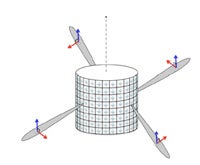
As conceived by Guifu Zhang (University of Oklahoma) and colleagues, the Cylindrical Polarimetric Phased Array Radar would send horizontally and vertically polarized signals from radiation elements positioned on the surface of a cylinder roughly 9 meters (30 feet) high and 10 meters (33 ft) in diameter. (Image courtesy Guifu Zhang.)
The trick in producing a dual-pol phased-array radar will be figuring out how to vary the polarization of many transmitters in a way that’s workable and affordable. “That’s the million-dollar question,” says NCAR’s Vivekanandan. His group and Lincoln Laboratories are now collaborating on an 18-month study to sketch out such a transmitting/receiving system that might conceivably replace the aging Electra Doppler Radar (ELDORA), which now flies aboard a Naval Research Laboratory C-130 aircraft.
Meanwhile, a geometrically novel option is taking shape in Norman, Oklahoma. With NOAA and NSF support, OU’s Guifu Zhang is working with NSSL radar veterans Doviak and Zrnić and colleagues from OU’s Atmospheric Radar Research Center on a prototype for a cylindrical dual-pol phased array radar (see diagram). Still in its early stages, the concept may help fix one major problem: when the beam of a phased-array radar points in a direction other than perpendicular from its flat-plate origin, the beam ends up striking targets at an angle. The polarization changes, and the resulting signals are distorted and cannot be easily related to precipitation properties. In a nutshell, says Zhang, “horizontal polarization isn’t in horizontal anymore.”
The cylindrical configuration envisioned by Zhang would avoid this problem, and produce dual-pol signals and measurements that aren’t degraded by scan angles. On the down side, it’s proving to be a complex system to design and build, with a number of bugs to be worked out. In a talk presented in January at the annual meeting of the American Meteorological Society, Zhang unveiled the cylindrical concept, which is also detailed in an upcoming paper in the Journal of Atmospheric and Oceanic Technology. He sees the design as a natural fit for weather surveillance: “It would open many opportunities for advancing technology and improving service. It is a great challenge, but feasible.”
When the first national network of Doppler radars came on line in the 1990s, the volume of data it produced was far greater than could be transmitted to universities via the Internet circuits of the day. Realizing the value of the radar data to university researchers and educators, UCAR’s Unidata program establlished a network of relay sites that allowed universities to access some or all of the Level II and Level III radar data in near real-time. (The two levels correspond to varying amounts of detail.)
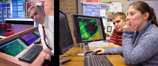
Software engineers Julien Chastang and Yuan Ho are among the Unidata staff who create radar displays for the program’s many university clients. Shown on the monitor is reflectivity from the NWS dual-pol testbed radar in Norman collected during Oklahoma’s snowstorm on 1 February 2011. The depiction was created by Unidata’s Integrated Data Viewer, which allows for three-dimensional visualization of data from many different radar formats.
Unidata’s Internet Data Distribution (IDD) system is based on the Unidata Local Data Manager (LDM), which “pushes” observational and model data to participating sites. The Unidata Program Center and several other nodes receive data from the NOAAPORT Satellite Broadcast Network (among other providers) and retransmit it to university sites, which can in turn retransmit the data. The result is a robust and efficient network that allows member institutions to receive as much data as they require, while giving back to the community as much as their resources allow.
Unidata staff are now keeping an eye on the NWS dual-pol radar upgrade, which will more than double the volume of radar data being generated. “We’ll be working with the community on this,” says Linda Miller, Unidata’s community liaison. Miller notes that the IDD system currently in place can easily handle the increased data volume, although individual universities may need to adjust the set of products they receive, depending on local bandwidth availability.
Unidata also provides tools that allow its community to analyze radar data in useful ways—for example, software that maps local radar data onto a national composite. Before it embarked on creating software tailored to the dual-pol data, Unidata consulted its user community to learn what features were most needed and desired. “I expect things will happen in a staged way,” says Unidata software engineer Tom Yoksas of the addition of software features specific to the dual-pol systems.