Turning the tables on chaos: Is the atmosphere more predictable than we assume?
May 6, 2011 - by Staff
Temporary impacts to NSF NCAR Road, Parking Lot and Trails
View more information.May 6, 2011 - by Staff
6 May 2011 • In the fall 2010 issue of UCAR Magazine, I discussed the excellent forecast of last year’s Hurricane Earl, the societal benefits of such forecasts, and some of the reasons why these forecasts have steadily improved. Here I discuss atmospheric predictability in general and present some remarkable examples of recent successful experimental predictions of some high-impact mesoscale phenomena—the kind of forecasts that may become commonplace ten years from now.
Estimating the predictability of the atmosphere has intrigued philosophers, mathematicians, and scientists for many years. Gottfried Leibniz (1646–1716) imagined seeing the future: “Everything proceeds mathematically . . . if someone could have a sufficient insight into the inner parts of things, and in addition had remembrance and intelligence enough to consider all the circumstances and take them into account, he would be a prophet and see the future in the present as in a mirror.” The Marquis de Laplace (1749–1827) dreamed of an intelligent being (later dubbed Laplace’s Demon) who knew the positions and velocities of every single atom and used Newton’s equations of motion to predict the future of the entire universe.
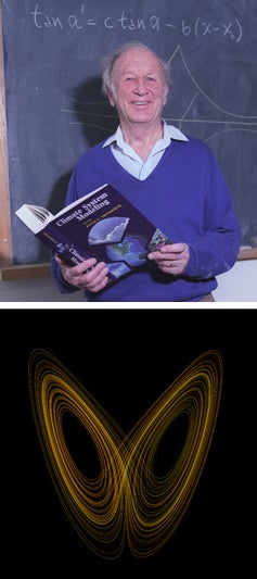
Edward Lorenz (top), a long-time NCAR visitor, devised a system of equations in which very similar initial conditions led to two different outcomes, as shown by the two loops in the illustration. (Top photo © UCAR; this image is freely available for media and nonprofit use. Bottom image courtesy Wikimedia Commons.)
Nearly two hundred years after Laplace’s speculation on deterministic predictability, Edward Lorenz (1917–2008), a meteorologist from MIT (and a frequent summer visitor to NCAR) discovered that perfect deterministic forecasts of weather were impossible. As a young meteorologist, Lorenz had thought that weather would be ultimately as predictable as eclipses, but he later discovered that the growth of small errors in numerical models limited atmospheric predictability to a few weeks. In so doing Lorenz discovered chaos theory, which some have placed alongside relativity and quantum mechanics as one of the three great scientific revolutions of the 20th century.
A good sense of Lorenz’s achievements can be gleaned from two papers he wrote in 1963: the descriptive “The predictability of hydrodynamic flow,” published in Transactions of the New York Academy of Sciences and the classic theoretical paper “Deterministic nonperiodic flow” in Journal of the Atmospheric Sciences.
In 1972, Lorenz presented a talk at the annual meeting of the American Association for the Advancement of Science. It was fatefully titled, “Predictability: Does the flap of a butterfly’s wings in Brazil set off a tornado in Texas?” However, the title—and its reference to butterflies and tornadoes—was written not by Lorenz himself but by Phil Merilees, who introduced Lorenz at the AAAS meeting. Lorenz had closed his first 1963 paper with a different biological metaphor:
When the instability of a uniform flow with respect to infinitesimal perturbations was first suggested as an explanation for the presence of cyclones and anticyclones in the atmosphere, the idea was not universally accepted. One meteorologist remarked that if the theory were correct, one flap of a sea gull’s wing would be enough to alter the course of the weather forever. The controversy has not yet been settled, but the most recent evidence seems to favor the sea gulls.
Lorenz realized that because the atmosphere was unstable, two almost identical states would diverge with time, so that after a certain period the two states would be indistinguishable from any two states taken at random. Of course, this divergence could not be tested using the real atmosphere, but it could be studied with numerical models and computers.
In the early 1960s, Jule Charney, Cecil Leith, Yale Mintz, and Joseph Smagorinsky did just this. They showed that small perturbations introduced into a control simulation grew with a doubling time of about five days, though the doubling time varied significantly based on the initial state of the model atmosphere (some initial states were more unstable than others). Experimenting in the 1980s with more realistic global models, Lorenz found considerably shorter doubling times, around 3.5 days. Given realistic estimates of initial errors, these simulations led to the conclusion that the limit to useful deterministic predictions of large-scale (synoptic) atmospheric motion was about two weeks. It was also widely thought that deterministic predictability was related to the sizes and lifetimes of the phenomena, so that predictability of mesoscale phenomena was limited to the lifetime of each phenomenon.
While I was an assistant professor at Pennsylvania State University in the early 1970s, my first Ph.D. student, Thomas Warner, and I began converting the 3-D hurricane model I had developed in Miami to a general limited-area mesoscale model. We called it the “Meso Monster,” or MM, because of its size and complexity. This work, aided by many graduate students and collaborators, eventually led to the fifth generation Penn State-NCAR mesoscale model MM5, which was widely used by scientists around the world.
However, not everyone thought that mesoscale modeling was worth the effort. At one seminar I gave in the mid-1970s at the National Meteorological Center (NMC, which is now the National Centers for Environmental Prediction), a highly respected senior scientist asked why I was wasting my time developing a model with horizontal grid spacing so much smaller than the average spacing between radiosondes (about 30 kilometers versus 500 km). A year or so later, in 1978, Tom and I published the first paper describing the MM in Monthly Weather Review, in which we argued:
It is doubtful whether a sufficient number of simultaneous initial observations will ever be available on a computational mesh for these scales, although some mesoscale variability may be revealed by satellites. However, nonlinear processes are capable of producing smaller scale information in the forecast than is present in the initial conditions, as long waves interact to produce energy in shorter waves. Furthermore, a realistic treatment of local forcing in the models will allow mesoscale perturbations to develop from initial conditions that are representative of larger scales. Thus we hypothesize that in many synoptic situations, if the local forcing is modeled correctly, the details of the initial perturbations are not particularly important.
My belief that mesoscale models could be useful even in the absence of high-resolution observations strengthened over time. In a chapter titled “The General Question of Predictability” in the 1986 American Meteorological Society book Mesoscale Meteorology and Forecasting, I hypothesized that mesoscale features might be predictable one to three days in advance if synoptic-scale features could be accurately modeled. A number of early results with MM and other mesoscale models seemed to support this hypothesis. Midlatitude fronts, Mei-Yu fronts (an important part of spring weather in East Asia), mesoscale convective complexes, dry lines, and flash floods were simulated or forecast from large-scale initial conditions.
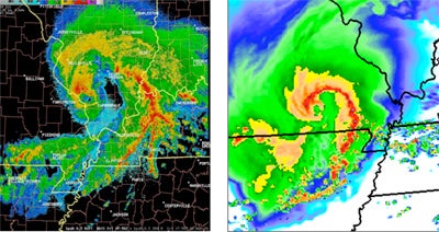
At left, a radar image from 1756 UTC on 8 May 2009 shows the bow-shaped structure of a “super derecho” centered over southern Illinois, with a tropical-storm-like eye in the center. The WRF model forecast (right) at 1545 UTC on 8 May—a 27-hour forecast—accurately predicted this rare structure. (Images courtesy Morris Weisman, NCAR.)
Since the early days of MM, mesoscale models have advanced considerably, and computers that are more than a billion times faster than in the early 1970s have enabled simulations and forecasts that feature much higher resolution and cover larger domains, even global. These advances have led to intriguing experimental forecasts that auger well for the operational prediction of high-impact mesoscale phenomena in the near future. Below are some examples that I find especially encouraging.
In the January 2011 issue of the Bulletin of the American Meteorological Society, Morris Weisman (NCAR) and colleagues describe a successful forecast of a mesoscale vortex with a derecho, a violent windstorm associated with a curved band of severe thunderstorms that appeared as a bow echo on radar. A 27-hour forecast from a 3-km-resolution version of the Weather Research and Forecasting model (WRF) successfully depicted a mesoscale convective system closely resembling the derecho that occurred. Preliminary analyses suggest that the intense mesoscale rotation associated with the derecho was produced almost entirely by the convection itself. This is similar in some respects to the early stages of tropical cyclones, although midlatitude thunderstorms grow in environments with much stronger thermodynamic energy and vertical wind shear.
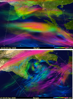
Five days before producing Cyclone Nargis, a simulation led by Bo-Wen Shen (NASA) started with the large-scale initial conditions at the top (0000 UTC 22 April 2008). Wind speed and direction are indicated by colored lines, with blue and green shades denoting lower tropospheric flow, red denoting upper tropospheric flow, and color intensity proportional to speed. The five-day forecast valid at 0000 UTC 27 April 2008 (bottom) shows the eventual Cyclone Nargis in the Bay of Bengal. (Images courtesy Bo-Wen Shen.)
In another series of remarkable results, Bo-Wen Shen (NASA Goddard Space Flight Center) and colleagues have predicted genesis of actual tropical cyclones using a high-resolution global model (about 28 km) and synoptic-scale initial conditions. For example, as described in the Journal of Geophysical Research in 2010, the model produced a successful five-day forecast of severe Cyclone Nargis (2008), which caused more than 100,000 fatalities and $10 billion in damage in Myanmar, Bangladesh, India, and Sri Lanka. Large-scale factors that led to the predictability of the genesis of Nargis included a westerly wind burst and equatorial trough, an enhanced monsoon circulation, upper-level divergence with anticyclonic shear between upper and lower levels, and low-level moisture convergence. For a beautiful animation of this forecast, please see the “Selected Visualizations” page of Shen’s website, from which the illustrations at right are drawn.
The Nargis forecast was not an isolated event. Shen also reports successful ten-day forecasts of the development of twin tropical cyclones on opposite sides of the Equator. Their formation was closely associated with the Madden-Julian Oscillation, a large-scale phenomenon affecting the tropical Indian and Pacific oceans. In the Atlantic, Shen has shown the importance of accurately predicting African easterly waves in forecasts of tropical cyclone genesis; he also produced a successful four-week forecast that depicted the genesis of Hurricane Helene (2006) after three weeks and its subsequent track over the next week.
Of course, the above examples are anecdotal, and much work is still required to determine how often these achievements occur, as well as the probability of a single forecast being successful. And while scientists may recognize such forecasts as being remarkable achievements, relatively small errors in the predicted locations of intense mesoscale phenomena may result in very large errors in conventional measures of forecast skill, as well as large errors in predicting the weather that people actually experience. Still, knowing days in advance that such intense and rare phenomena are likely to develop may prove useful for people throughout regions at risk.
In summary, while small-scale errors may eventually contaminate the forecasts of large-scale circulation patterns, scale interactions go both ways. As noted above, the pioneers of predictability theory recognized that the degree of predictability varies greatly depending on the initial state of the atmosphere: some states are much more predictable than others. Good predictions of the large-scale atmospheric flow patterns may lead to predictability of much smaller-scale phenomena hours or even days before they form. An African wave forming to the lee of the Ethiopian Highlands might well portend a hurricane threatening the Texas coast two weeks later—butterflies or no butterflies.