Corn and climate: a sweaty topic
Jul 21, 2011 - by Staff
Temporary impacts to NSF NCAR Road, Parking Lot and Trails
View more information.Jul 21, 2011 - by Staff
Bob Henson | 21 July 2011 • If you’re an American, it’s tough to avoid corn. This ubiquitous starch turns up in soft drinks, compostable cups, and automobile fuel. It even plays a role in U.S. heat waves, including the intense one now under way.
Corn yields have steadily increased across the United States since the mid-20th century. (Image by Jonathunder, Wikimedia Commons.)
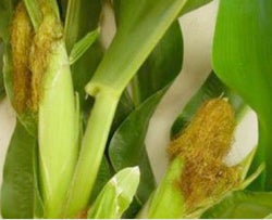
Like a giant wick, a growing corn plant pulls moisture out of the soil. Some of that moisture escapes through the plant’s leaves and enters the atmosphere (transpiration). Water vapor also enters the air from lakes and other surfaces (evaporation). Together, the processes are known as evapotranspiration, the topic of a recent post at weather.com. The hotter the surrounding air, the more water it can absorb from corn leaves, as long as the corn has an ample supply of soil moisture.
Evapotranspiration has unfolded on a grand scale in recent days across the nation’s vast Corn Belt, which is centered in Iowa (see map below). With corn plants now beginning to “tassel” in many areas, the plants’ leaf area—and their ability to transmit moisture—is close to its peak.
The corn-driven injection of moisture is being fed this year by especially wet soils after this spring’s record Midwest rainfall. And, unfortunately, it coincides with the onset of one of the worst American heat waves in years. The result is a combination of heat and humidity that’s causing misery for millions. Heat indices—the effective temperatures that takes moisture into account, as opposed to actual temperatures—soared to as high as 131°F at Knoxville, Iowa, on 18 July.
It’s the humidity and the heat
The mugginess swaddling the Midwest—and now the mid-Atlantic—is a different beast from the torrid air mass that’s plagued the Southern Plains for weeks (link added 8/18/11). As of 19 July, Oklahoma City had seen 28 days this year at or above 100°F. The city’s 110°F reading on 9 July was its hottest in history, apart from two days in August 1936 at the height of the Dust Bowl. The scorching weather in Texas, Oklahoma, and vicinity has been driven mainly by a historic drought, with the parched land heating up quickly each day.
Further north, the record heat arrived more recently, as a huge dome of high pressure took shape over the weekend. Daytime temperatures have been toasty enough, breaking 100°F in many spots. What’s more notable, though, are the very high humidities and the extremely warm nights, as evident on the National Climatic Data Center’s recently upgraded U.S. records page. For example, on 18 June, 58 U.S. locations tied or set daily record-high maxima, but a more impressive total of 294 sites tied or set daily record-high minima. And 11 of those locations tied or broke their records for the warmest low temperature ever experienced on any date.
It’s no surprise that many of these records were set in or near the Corn Belt, where the moisture-laden atmosphere has kept nights extremely sultry. Along with transpiration from plants, many of the region’s river valleys are bloated with runoff, which allows even more water to evaporate close to the largest population centers. Moreover, the stagnant atmosphere has kept water vapor pooled close to the ground, instead of it mixing more deeply through the atmosphere.
In Minneapolis, the dew point (a measure of the absolute amount of water in the atmosphere, as opposed to relative humidity) reached 81°F on 18 July, That’s as high a dew point as the city has ever recorded.
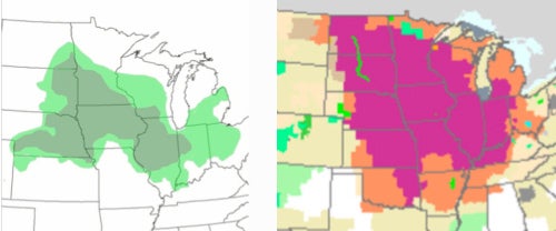
The areas of greatest U.S. corn production (left) span a belt from Nebraska to Indiana. At right, excessive heat warnings covered much of the Midwest on several days around 18 July. (Left image by Elikos91, Wikipedia; right image courtesy National Weather Service.)
Stephen Corfidi, a forecaster with the NOAA Storm Prediction Center, has been keeping an eye on Midwestern moisture trends for decades. “Subjectively, from analyzing surface data over my career, I would say with near certainty that surface dew points have increased in the upper-mid Mississippi and lower Ohio Valleys over the last 30 years,” Corfidi told me by e-mail. “In particular, it seems as though broad swaths (say, 300- to 50-mile–wide corridors) with surface dew points averaging in the mid 70s Fahrenheit are no longer uncommon.”
NCAR’s Peggy LeMone was inspired by a chat with Corfidi to look further into the issue. As she explains in a 2007 blog post, corn is being grown in ever-more-dense fields, and this could be helping to boost dewpoints. However, the exact role of intensified cropping is difficult to isolate. Corn-based agriculture is shifting in a variety of ways, including the use of longer-season cultivars and earlier planting, as recently noted by scientists from NCAR and the University of Wisconsin–Madison.
Corfidi thinks the dewpoint increase may not be attributable entirely to agriculture. Automated weather stations are being deployed by a variety of parties, and as researchers at Iowa State University have observed, some sensors are located amid cornfields. "At least in my mind, instrumentation changes are a big unknown in trying to assign cause for the observed increase in dew points. There may well be others,” says Corfidi.
Getting corn in the forecast
Given the huge importance of corn to the nation’s economy, there’s a wealth of research on how weather and climate affect its growth. But how well do we take corn itself into account when issuing weather forecasts or climate projections?
Meteorologists are quite savvy about the summer moisture spikes that corn helps produce. A National Weather Service forecaster in Des Moines took note of the effect in the office’s morning discussion on 15 July (these discussions are always composed in capital letters):
GIVEN THE PEAK EVAPOTRANSPIRATION SETTING IN FOR THE CROPS AS CORN BEGINS TO TASSEL AND POLLINATE...MUCH MOISTURE WILL BE ADDED TO THE AIR AS WELL. WILL SEE DEWPOINTS LIKELY INTO THE LOWER 80S DURING THE WEEK...ESPECIALLY IN THE AFTERNOON AND EVENING HOURS.
Computer models also take vegetation into account. As used by the National Weather Service, the Weather Research and Forecasting model—which divides the United States land area into rectangles roughly 7.5 miles (12 kilometers) on each side—incorporates daily satellite data on the greenness of the landscape within each rectangle (though not on specific plant types). The model then assesses how much water will enter the atmosphere via the vegetation in each grid box. Forecasters can adjust the resulting model guidance based on their knowledge of local planting patterns and crop behavior.

NCAR’s Samuel Levis (left) has been working this summer on interactive crop-climate modeling for the Midwest with Graylen Boone, a recent meteorology graduate from North Carolina State University and a protégé with UCAR’s SOARS program. (Photo by Carlye Calvin.)
There’s also increasing attention to how crops are portrayed in climate models. NCAR’s Linda Mearns and colleagues pioneered the representation of wheat, corn, and other crops in regional climate models in the 1990s. The scope of the work expanded to consider crop-climate interactions and the effects of climate change. In 2007, the UK’s Hadley Centre unveiled the first results from a global model that included two-way agriculture, where both crops and climate are free to evolve in response to each other.
That approach is now being adopted by NCAR in its Community Earth System Model. Samuel Levis recently evaluated the annual cycle of the CESM’s coupled atmosphere-land component. It includes new software that tracks the behavior and carbon uptake of corn, soybeans, and midlatitude cereals (including wheat).
“The Midwest is the only place in the world where these crops cover more than half of a grid box,” says Levis. Each CESM box spans 1.9° by 2.5° degrees at midlatitudes, or about half the area of Iowa.
In results soon to be submitted for publication, Levis and colleagues are finding that the new model performs well against a control model that substitutes unmanaged grasslands for croplands. The improved model shows an overall decrease in soil moisture compared to its predecessor, with crops sending more water than unmanaged grasses into the atmosphere.
When corn does have plenty of access to water during midsummer, as is the case in 2011, the extra transpiration ought to lead to compressed temperatures: muggier nights but not-quite-so-hot days, with less overall warming than other parts of the United States. That’s the very pattern documented in recent years by several researchers, including Christopher Anderson (Iowa State University).
There’ll be a great deal more to learn as fully interactive crop-climate models evolve, says Levis: “We're still at a early stage.”
Update - 21 July 2010 | Bill McAuliffe at the Minneapolis Star-Tribune informs me that the city broke its record noted above with an 82°F dew point in an hourly observation on 19 July. The NWS is now working to verify an even higher dew point reading of 84°F recorded in between hourly data points. And at Moorhead, Minnesota, the dew point soared to an amazing 87.8°F. If that value holds up, it'll be a new state record. Here's a good summary by meteorologist and Star-Tribune blogger Paul Douglas.
Update #2 - 21 July 2010 | This post from Iowa State University's Iowa Environmental Mesonet shows how automated stations differed on this week's moisture.