Satellite observations of Earth: A national priority still at risk
Sep 7, 2011 - by Staff
Early closure on July 3 and 4 - NSF NCAR Road, Parking Lot and Trails
View more information.Sep 7, 2011 - by Staff
8 September 2011 • The spring and summer of 2011 brought the United States a string of disastrous weather-related events unmatched in recent years.
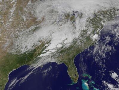
By 1:45 p.m. CDT on 27 April 2011, a deadly outbreak of severe thunderstorms and tornadoes was under way across the U.S. South. (NOAA GOES image courtesy NASA Earth Observatory.)
The human and economic costs of these disasters would have been even greater without NOAA’s satellite and radar observations and weather forecast models. Since the 1960s, U.S. satellites have allowed forecasters to track critical weather details that cannot be seen from the ground. The benefits of being able to see thunderstorms and hurricanes in real time are obvious. However, there are much larger satellite-derived benefits to weather forecasting that often go unrecognized by the general public (and even by some meteorologists).
Satellite observations are the backbone of numerical weather prediction (NWP) models, which in turn are the foundation for modern-day weather prediction, giving us a “heads up” on severe winter snowstorms, hurricanes, and tornado outbreaks days in advance. The imagery from geostationary satellites (satellites in orbit over the Equator and rotating at the same speed as Earth, thus remaining over the same place at all times) is critical for monitoring weather hour by hour and day by day. Polar orbiters (satellites that orbit over the poles and cross a given place on Earth once a day) carry instruments that profile temperature and water vapor across the globe, including oceanic areas where other data sources are limited.
The world’s leading NWP centers have shown that observations from polar-orbiting satellites are the most important for boosting the accuracy of weather predictions, even ranking above data from surface weather stations and radiosondes. This can be seen in the figure below, which shows the percent reduction in forecast error due to all observing systems used for operational weather modeling at the European Centre for Medium-Range Weather Forecasts (ECMWF). Four out of the top five observing systems, and eight of the top ten, are polar-orbiting satellite systems. Together, the top five contribute nearly 60% of the total error reduction, and the top ten contribute more than 80%. Clearly, today’s weather forecasts depend critically on satellite observations.
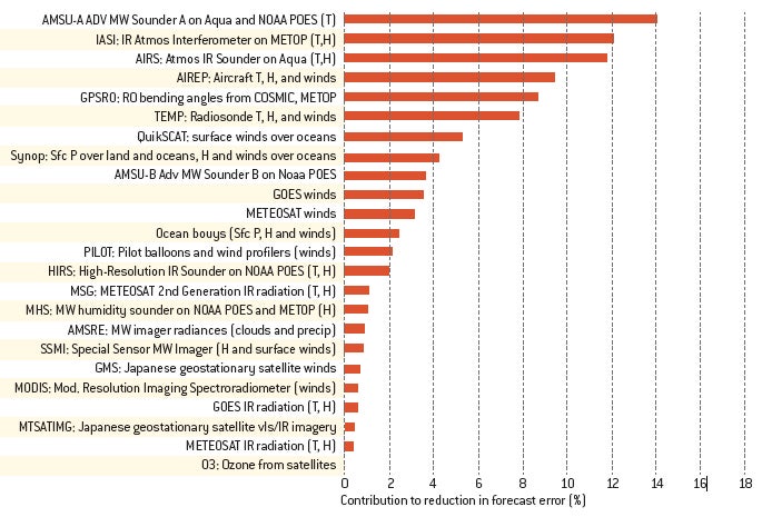
This chart shows the reduction in forecast error associated with different observing systems used by the European Center for Medium-Range Weather Forecasts (ECMWF) in late 2008. Four of the top five observing systems are polar orbiting satellites that provide atmospheric soundings (microwave, infrared, and radio occultation). Aircraft reports round out the top five. (Illustration courtesy ECMWF.)
In early 2007, the National Research Council issued its first-ever “decadal survey” for Earth sciences, which prioritized key observations of Earth from space (Earth Science and Applications from Space: National Imperatives for the Next Decade and Beyond). Berrien Moore (now at the University of Oklahoma) and I served as co-chairs for this effort. A preliminary 2005 report had observed that the U.S. system of Earth observing satellites was “at risk of collapse” (Earth Science and Applications from Space: Urgent Needs and Opportunities to Serve the Nation).
Our committee made the case that a balanced set of observations of the Earth system was critical for human health, safety, and economies. The decadal survey called for a renewal of U.S. commitment to a robust system of satellites to support not only weather prediction and warnings, but also agriculture, transportation, water resource management, and national security. The survey was well received by the Bush administration and Congress, and the outlook for the U.S. system of satellites following its release brightened considerably.
This year the NRC is conducting an assessment of progress made on the recommendations in the decadal survey. The results are decidedly mixed and, overall, disappointing after a promising start.
Supported by Congressional budget appropriation increases in fiscal years 2009–11, NASA began a serious effort to implement the missions recommended in the survey, focusing on the first-tier (near-term) missions:
It gradually became clear that the appropriated NASA budgets, though increasing, would be significantly below what was recommended by the decadal survey. In addition, it became evident that the 15 planned missions were going to cost significantly more than the survey estimated. Then, in 2011, the Office of Management and Budget (OMB) put two of the missions on indefinite hold: CLARREO and DESDynI (Deformation, Ecostructure and Dynamics of Ice). It is now impossible to implement the survey recommendations for NASA close to the schedule proposed in 2007.
At NOAA, much attention has been focused on its next-generation systems, the Geostationary Operational Environment Satellite–R Series (GOES-R) and the Joint Polar Satellite System (www.nesdis.noaa.gov/jpss). JPSS was created in 2010 when the joint DoD-NOAA-NASA program, NPOESS, was canceled in favor of separate civilian and military polar-orbiting satellite systems. Originally part of NPOESS and scheduled for launch in 2005, the NPOESS Preparatory Project (NPP) was designed as a way to bridge the gap between current and next-generation systems for both civilian and defense purposes.
As with NASA, the picture at NOAA is disappointing. The survey recommended that NOAA restore several key observing systems to NPP, JPSS, and GOES-R:
The survey also recommended investigating the possibility of incorporating a temperature and water vapor sounder on the GOES-R series.
NOAA is now incorporating the first two systems above on NPP. However, because of budget limitations and growth in the costs of NPOESS, it has dropped the third system, and it has been unable to implement the survey recommendations for a scatterometer on either NPP or JPSS-1 to measure sea surface winds. The agency has also dropped plans to include a sounder on the GOES-R series.
The survey noted the value of radio occultation—which produces high-resolution vertical profiles of temperature, water vapor, and electron density—and recommended moving this new technology from research to operations. NOAA has since developed a partnership with Taiwan and the U.S. Air Force to develop a follow-on to COSMIC. However, because of shortfalls in the budgets appropriated for JPSS, the agency has not yet committed even a small amount of funding needed to officially begin this low-cost, high-impact program, thus putting the partnership with Taiwan at risk.
Since the decadal survey was released, progress on foundation missions that were already planned has also been uneven. On the positive side, the ocean altimetry mission Jason-2 was successfully launched by NASA in 2008. This success was followed by a major setback with two NASA launch failures, the Orbiting Carbon Observatory (OCO) in 2009 and Glory in 2011. OCO was a NASA satellite mission intended to provide global observations of atmospheric carbon dioxide, while Glory was intended to measure atmospheric aerosols and total solar irradiance. (Both launches were unsuccessful for the same reason: the fairings on the Taurus-XL rockets failed to separate properly.) Fortunately, the Earth sciences got a boost after these two demoralizing launch failures when Aquarius/SAC-D—a joint NASA–Argentine Space Agency mission to provide global measurements of variations in sea-surface salinity—was successfully launched by NASA on 10 June 2011.
The next major launch of a U.S. Earth observing satellite will be NPP, now expected to launch on 25 October 2011. Success of NPP is critically important because of likely delays in the launch of JPSS-1, originally scheduled for 2016 to coincide roughly with the end of NPP. JPSS-1 will carry the same instruments as NPP, thus ensuring continuity in these important missions if NPP lasts a full five years and JPSS-1 is launched on time.
However, Congress passed a NOAA satellite budget for fiscal year 2011 that was short by almost $700 million, funds needed to keep JPSS-1 on schedule. The resulting delay could lead to a significant gap in meteorological satellite data coverage over the U.S. and the world. This gap is likely to slow or reverse the steady upward trend in forecast accuracy and severe weather warnings that has been occurring over the past several decades, unless other new satellite programs provide observations to compensate for the gap.
The story of the U.S. research and operational Earth observing system from space since the decadal survey was published in early 2007 has some bright spots, but it is far from meeting the optimistic plans and hopes for a revitalized national satellite system that would benefit so many areas of society. Ominously and inevitably, older missions (launched prior to 2007) are dying, such as ICESAT-1 (Ice, Cloud, and Land Elevation Satellite), Landsat-7, and the scatterometer on QuikSCAT. Our sentinel system in the sky is at risk of going blind.
The nation’s investment in Earth satellites is a bargain. Not only do these data save lives and reduce injuries, but the observations and predictions provide economic savings and spur productivity at an annual rate many times their cost. We cannot afford to move backward.
With society’s ever-increasing complexity and vulnerability to floods, tornadoes, hurricanes, heat waves, and other high-impact weather, the increase in environmental ignorance that results from losing satellite coverage is unacceptable. Demand for accurate weather and climate information is increasing in all sectors of the U.S. economy—agriculture, water and energy management, transportation, health, emergency preparedness, and the military. Adequate funding of Earth observations from space is a life-saving and cost-effective investment. A great country and a world leader must have accurate and timely weather and climate intelligence.