Predicting snow in the Anchorage Bowl
Nov 17, 2011 - by Staff
Temporary impacts to NSF NCAR Road, Parking Lot and Trails
View more information.Nov 17, 2011 - by Staff
Researchers and forecasters work together to improve forecasts where the mountains meet the sea.
November 17, 2011 • Local geography, such as a mountain range or large body of water, can greatly affect snowfall amounts. This is especially true in Anchorage, Alaska, nestled between the Chugach Mountains and Pacific Ocean.
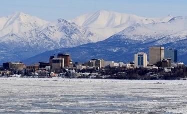
Anchorage, Alaska. (Photo by Frank K., Wikipedia Commons.)
Thanks to a recent partnership between the University of Alaska Anchorage and the National Weather Service (NWS), Anchorage residents may get better forecasts of winter snowfalls. The research was facilitated by UCAR’s COMET Program, which focuses on education and training for the environmental sciences.
The Anchorage Bowl, as it's known, averages about 70 inches (178 centimeters) of snow per year, most of it falling between December and February. Forecasting for the area can be difficult due to the region’s varied and rugged geographical features. This is especially true when a low pressure system builds over nearby Prince William Sound (PWS). These lows, which bring warm air and moisture into the bowl, have been anecdotally associated with major snowstorms in Anchorage.
The goal of the research project was to examine the relationship between significant snowfall events in Anchorage and the presence of PWS lows, in hopes of improving weather forecasts. The research team, led by the University of Alaska’s Peter Olsson and the NWS’s James Nelson, compiled a climatology of significant snowfall events (defined as storm totals greater than 6 in, or 15 cm) in Anchorage between January 1997 and December 2006. They then narrowed this down to events associated with PWS lows.
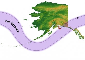
A potent setup for snowfall in Anchorage occurs when energy moving along the upper-level jet stream (purple) triggers formation of a surface low-pressure center (red) that moves into Prince William Sound (PWS). The mountains lining the sound (see photo, above) help force air upward. However, a small difference in the track of the PWS low can greatly affect how much snow falls. If the low moves toward the west side of the sound, more than a foot of snow may occur in and near Anchorage in less than 24 hours. These amounts are greatly reduced if the low tracks toward the east side of the sound. Scientists are gaining traction on predicting the behavior of PWS lows through a study facilitated by UCAR's COMET Program and carried out by the University of Alaska Anchorage and the National Weather Service. (Illustration ©UCAR.)
The results show that snowfalls characterized by PWS lows comprised just over half of all significant storms for Anchorage for the study period; the contribution of PWS lows to the total snowfall for the study period was 24%.
The team’s next step was to focus on a particular storm that occurred on February 9, 2005, as a case study to see if weather models could reproduce the event. The storm, which occurred during a PWS low, produced about 7 in (18 cm) of snow in
Anchorage. The researchers used the NCAR-based Weather Research and Forecasting model to simulate the storm and verify the results against real-world weather data from the event. The model captured the presence of the PWS low and accurately portrayed winds, though it overproduced precipitation.
Nelson says that the project has helped the Anchorage NWS office better understand PWS lows and their potential to produce significant snowfall for the area. “The study should help us predict PWS snowfall events with greater accuracy for both onset and amount of precipitation, so that we can provide better service to local officials and the public,” he says.
The University of Alaska benefited from the partnership as well, as its researchers became familiar with accessing NWS weather data and then analyzing it with NCAR Command Language (a data analysis and visualization tool) and VAPOR (a 3-D visualization software developed at NCAR). “This combination of access to regional datasets and new analysis tools will help us approach a variety of research questions,” Olsson says. He adds that university researchers are interested in pursuing future research projects with the NWS on additional weather phenomena in the Anchorage area, including high wind events, wind shear, and turbulence.

Vickie Johnson (©UCAR.)
The Anchorage snowfall project was facilitated by COMET’s Outreach Program, whose goal is to improve local forecasts and warning services by providing financial support for applied research that fosters relationships between academic researchers and operational forecasters. The program, which gets its financial support from the NWS, has sponsored more than 300 research projects since 1989, involving more than 80 universities and 100 forecast offices.
“We get really positive feedback about the Outreach Program,” says COMET’s Vickie Johnson. “The forecasters enjoy working on research, and they receive assistance on projects that will help them forecast better. On the university side, the researchers experience what it's like to forecast in the real world.”
Nearly all Outreach Program projects involve university students, she adds. “The students enjoy doing research that lets them see the applications,” she says. “Many have gone on to have careers at the NWS after working on these projects.”