Where snow is born: Getting on top of winter storms
Nov 14, 2011 - by Staff
Temporary impacts to NSF NCAR Road, Parking Lot and Trails
View more information.Nov 14, 2011 - by Staff
PLOWS campaign opens a window on how snow develops in clouds.
November 17, 2011 • If you’ve ever flown above the vast cloud deck of a winter storm, then experienced a few jolting seconds as you descended into it, you already know something about cloud-top instability. It turns out that small pockets of rising air near the tops of winter storms may play a large role in generating snowfall on the ground.
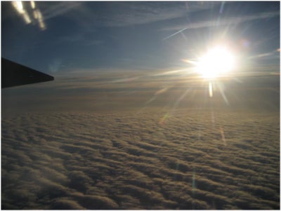
The view from the NSF/NCAR C-130 as it flew above a thick, snow-producing cloud deck while taking measurements for the PLOWS project on December 14, 2009. (Photo by Andrew Rosenow, University of Illinois at Urbana-Champaign.)
Researchers with the PLOWS project (Profiling of Winter Storms), which involved several UCAR member universities, are now in the thick of data analysis. The results from the NSF-funded project are giving scientists a richer three-dimensional understanding of how snow takes shape inside winter storms. In time, the insights could also help forecasters analyze how a storm is evolving and what people on the ground can expect.
“We’ve made a number of fundamental discoveries,” says PLOWS leader Bob Rauber (University of Illinois at Urbana–Champaign). He and several students are among the PLOWS participants now working on papers to be submitted over the next few months. “We’re still on a pretty steep learning curve, but we’re getting close,” Rauber says.
At two recent conferences held by the American Meteorological Society, Rauber and colleagues presented striking preliminary results from the data they gathered across the Midwest in 2009–10 and 2010–11.
One of the most illuminating cases captured by PLOWS was a winter storm that dropped 12 to 15 inches (30–38 centimeters) of snow across parts of Iowa and neighboring states on December 9, 2009. The top part of the graphic below is a composite of images from standard, ground-based Doppler radars that shows the classic comma shape of a mature winter storm.
“Our longstanding interpretation of winter storms is based on what you see in that top panel,” says Rauber. But as he and colleagues found out, there’s more going on than meets the eye on ground-based radar.
The new perspective came largely from research radar and lidar (laser-based radar) flown into snowstorms aboard the NSF/NCAR C-130 aircraft. The Wyoming Cloud Radar gathered data with a razor-sharp resolution of 15 meters (about 50 feet). Vertical profiling of the storms with this radar allowed the investigators to see storm features invisible to the standard WSR-88D radars used in daily forecast operations, which have much lower resolution and sensitivity.
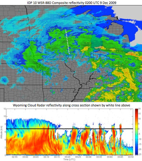
Two views of a winter storm. A composite of ground-based Doppler radar data (top) shows the classic comma shape of a well-developed storm. As the NSF/NCAR C-130 flew along a path shown by white dotted lines in the top image, its upward- and downward-pointing cloud radar detected narrow cloud-top streamers toward the north end of the storm (top left of bottom image) and deep convective towers toward the south end (right edge of bottom image). (Images courtesy Bob Rauber.)
The aircraft’s track allowed for a cross-sectional view as it passed through the storm, as shown by the dashed white line in both the top and bottom images. As it looked upward, the radar detected a set of narrow, feathery streamers (blue and green) descending from cells near the top of the storm (at top left of bottom image).
Each streamer is about 1.3 miles (2 kilometers) tall and anywhere from a half-mile to a few miles wide. That’s about the size of an ordinary cumulus cloud you might see in midsummer, when sunshine heats the ground and columns of warm, moist air rise (a process called convection). In this case, however, it’s December, and the clouds are at altitudes where the air is typically colder than –22°F (30°C), so the pockets of convection came as more of a surprise.
Rauber and his collaborators aren’t yet sure what is driving the apparent cloud-top instability. However, it appears to be different from other forms of instability long associated with winter storms. It’s also surprisingly common, says Rauber: “These features are ubiquitous. We saw them in almost every case.”
Preliminary results suggest that the broad field of snow falling through a winter storm’s comma cloud originates in the cells that produce the narrow streamers. Updrafts in these cells can reach about 7 mph (3 meters per second)—quite strong for a winter system. Once the streamers descend into the heart of the storm, they appear to merge into a broader area where smaller snowflakes collide and coalesce into larger flakes. Rauber and his research team are focusing on understanding these cloud-top features, a new aspect of winter storm dynamics made evident through PLOWS.
Where there’s instability and precipitation, there’s often thunder. Some of the PLOWS cases involve reports of lightning during snow. However, the 3-D structure of these electrified snowstorms isn’t yet known. For example, one of the graduate students on Rauber’s team is examining data from a ground-based electric field mill, airborne and ground-based radars, and lightning detectors to see how variations in electric field correspond to other aspects of storm development.
Forecasters can already recognize when highly unstable air might lead to thundersnow—for instance, it’s relatively common during the most intense nor’easters along the mid-Atlantic, such as the “Snowtober” storm that occurred in late October 2011. However, PLOWS may help forecasters better understand borderline cases where the chance of thundersnow is less clear.
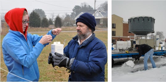
Left: PLOWS lead investigator Bob Rauber (right) prepares a radiosonde with graduate student Melissa Peterson (both from the University of Illinois at Urbana-Champaign) on January 16, 2010, in Moulton, Alabama. Right: Along with studying winter weather, PLOWS participants had to deal with it themselves. (Left photo by Joe Wegman; right photo by Bob Rauber.)
Rauber has already shared some of the findings from PLOWS with NWS forecasters, who’ve given him an enthusiastic reception. ”The initial reaction of the nearby office in Lincoln, Illinois, was, You’ve got to show this to everybody in the Midwest,” says Rauber. That office quickly arranged a teleconference to do just that with all the NWS science and operations officers (better known as SOOs) from the Midwest.
Instruments and collaborators for PLOWS came from the University of Missouri, University of Alabama at Huntsville, and University of Wyoming. The project also employed NCAR’s Mobile Integrated Sounding System, a vehicle equipped to launch and capture data from weather balloons, in addition to the C-130 aircraft.
>>>
Snow gaze: PLOWS scoops up insight (UCAR Magazine report from 2009 field phase)
PLOWS field support (NCAR's Earth Observing Lab)
PLOWS - University of Illinois