Winter weather: Story tips from NCAR and UCAR
BOULDER—Improved forecasting of winter storms and innovative technological systems to help keep winter drivers safe are among the goals of new work at the National Center for Atmospheric Research (NCAR) and collaborating organizations.
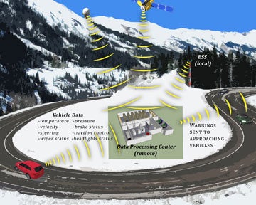
Help with winter driving hazards. Drivers could one day get warnings from the Vehicle Data Translator system, now in development and testing. (©UCAR. Illustration by Lex Ivey. See related background story for uncropped and high-resolution versions.)
Winter research extends from the tropics to Alaska and from the ground to the outer atmosphere. Areas of focus include the evolution of winter storms, wintertime events in the stratosphere that can jeopardize technological systems, improved tools to measure snowfall, projecting future spring snowpack in the Western states, and more.
In Depth: Winter Weather, a special report, provides background, photos, interactives, and video about winter-related research from NCAR and UCAR.
Research highlights
- Keeping drivers safe. NCAR is helping develop and test an innovative technological system that will eventually help protect drivers from sudden surprises like black ice, fog, and other hazardous weather conditions. The prototype system, called the Vehicle Data Translator and sponsored by the U.S. Department of Transportation, gathers detailed information about weather and road conditions from moving vehicles and relays alerts to other vehicles in the area.
“The goal is to reduce crashes, injuries, and deaths by giving drivers information about nearby hazards,” says NCAR scientist Sheldon Drobot. “The system will tell drivers what they can expect to run into in the next few seconds and minutes, giving them a critical chance to slow down or take other action.” | Winter driving: where the rubber meets the road >
- Improving snow forecasts. Scientists are making headway on deciphering the mechanisms that lead to snow formation within winter storms. One of the key findings from a recent field project, led by the University of Illinois and supported in part by NCAR aircraft and ground-based instruments, is that small pockets of rising air near the tops of winter storms may play a large role in generating snowfall on the ground. This research could one day help forecasters analyze how a storm is evolving and what to expect.
National Weather Service meteorologists are already being briefed on the preliminary findings, according to Bob Rauber, head of the Department of Atmospheric Sciences at the University of Illinois at Urbana–Champaign and leader of the recent field project. | Where snow is born: getting on top of winter storms >
- Could “Snowtober” happen again? Why did parts of the Northeast get buried by record snow last month? An analysis shows that the historic storm was fueled by a combination of a strong jet stream, unusually warm waters southeast of New England, and copious amounts of low-level moisture extending south toward the remnants of Hurricane Rina. Yet, no record low temperatures were set. | The October snow blitz: What made "Snowtober" so unusual?
- Measuring snow depth. Recent snowstorms have served as reminders of how difficult it is to accurately measure snow, given the effects of drifting, melting, and widely varying types of snowflakes. To replace old-fashioned yardsticks, scientists are developing a battery of high-tech tools, such as ultrasonic sensors and GPS-based technologies. Better snow measurements will help decision makers project water availability during the following summer, especially in mountainous areas that rely on runoff for agriculture and other needs. | Accumulated wisdom: How to measure snow >
- Projecting future snowpack. Recent research indicates that spring snowpack in many mountainous regions of Western states may disappear this century as temperatures warm. A new video and animation shows the outlook for spring snowpack in the West through 2100. | Spring snowpack in a warmer world >
- Protecting GPS signals. While storms and other winter events pound the lower atmosphere, the stratosphere is home to a different wintertime phenomenon: sudden warming events. Scientists are using computer models and observations to learn about these events, which can threaten radio communications, GPS signals, and other sensitive technological systems. | Winter's stratospheric reach >
- Linking the Indian Ocean to U.S. storms. An international field project in the Indian Ocean this winter, involving NCAR and numerous other organizations, seeks to better understand an atmospheric phenomenon known as the Madden-Julian Oscillation that affects global weather and climate patterns. The research could lead to improved long-term forecasts of winter storms in North America. | Scientists probe Indian Ocean for clues to worldwide weather patterns >
- Training forecasters. The University Corporation for Atmospheric Research (UCAR), which manages NCAR, trains meteorologists on atmospheric processes associated with winter storms. The classes, part of a wide spectrum of in-person and distance training run by UCAR’s COMET Program, are designed to improve forecasters’ skills in predicting winter weather. The COMET Program also links university researchers with National Weather Service meteorologists to carry out studies of mutual interest, such as a recent project to improve winter forecasts in the Anchorage area. | Predicting snow in the Anchorage bowl >
See all News