Wet and dry together
New ways to measure hydrologic extremes
Jan 3, 2012 - by Staff
Temporary impacts to NSF NCAR Road, Parking Lot and Trails
View more information.Jan 3, 2012 - by Staff
Bob Henson | January 4, 2012 • If 2011 could be dubbed the Year of Extreme U.S. Weather, its most tenacious element was the intense contrast between record drought in the Southern Plains and record-setting precipitation elsewhere. Both are noteworthy, and the combination is especially striking. But how best to quantify such a dual impact? Several indices help point the way.
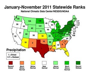
While Texas recorded its driest-ever year in 2011 (for the period January through November), New York and several other northeastern states had their wettest year on record. (Image courtesy NOAA National Climatic Data Center.)
Scientists have long known that human-induced climate change could boost both ends of the hydrological spectrum. As global temperatures warm, more water evaporates from the ocean, providing more fuel for heavy rain and snow. Warmer air also allows more moisture to escape from soils where drought has taken hold, making the ground even drier.
At the National Climatic Data Center, Thomas Karl and colleagues unveiled the U.S. Climate Extremes Index in 1995. One of the goals behind the CEI was to analyze U.S. data from recent years in light of the climate change projections put forth by the Intergovernmental Panel on Climate Change. The CEI now averages six different variables involving temperature, precipitation, and tropical cyclones. Two of these variables could shed particular light on the polarized pattern of 2011:
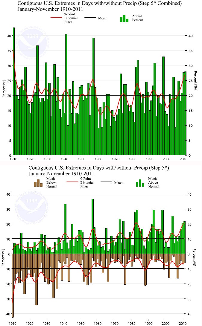
Step 5 in calculating the U.S. Climate Extremes Index involves measuring the amount of the country experiencing either an unusually large or unusually small number of days with precipitation over a given time span. When these two values are added (Step 5 combined, top), the total area has not changed dramatically in recent decades. However, the individual breakdown (Step 5, below) shows that the amount of territory experiencing many more wet days than usual has risen, while the area experiencing many more dry days than usual has gone down. Click on the dual image for a larger version. (Images from the Climate Extremes Index courtesy NOAA National Climatic Data Center.)
Data for December 2011 aren’t in yet, but the charts for January through November tell an interesting tale. The Step 5 Combined chart (top part of graphic at left; click to enlarge) includes the sum of both elements of Step 5: areas where the number of days with precipitation was either much above normal or much below normal.
This chart doesn’t paint 2012 as a total outlier. Several other years, including 1993 and 1998, featured a larger chunk of the U.S. experiencing either very many or very few wet days. And there’s no dramatic long-term trend in either direction.
However, the combined index could be masking an increase in the number of wet days accompanied by a decrease in very dry days. This appears to be the case, in looking at the main Step 5 chart (bottom part of graphic at left). There’s a visible trend toward areas with many wet days and away from areas with many dry days.
What about the classic climate-change scenario, where moist soil gets even moister even as drought-stricken areas dry out further? If we look at the Step 3 Combined chart (top part of graphic below), we see this principle in action. More than 55% of the nation in 2011 was either in severe drought or severe moisture surplus, according to the PDSI. That’s more than any other year on record. The runner-up is Dust-Bowl–ravaged 1934, where the high value came almost entirely from severe drought, as seen in the main Step 3 chart (bottom part of graphic below). In contrast, you can see that 2011’s contribution came more equally from very wet and very dry areas, reflecting the meteorologically polarized state of the nation. There’s also been a visible shift toward higher values overall since the 1980s, though with much year-to-year variability.
Taking a page from the CEI, a similar index was developed for Australia by Ailie Gallant and David Karoly (University of Melbourne). As in the United States, their index also shows a long-term rise in the total percentage of land at any given time that’s either very moist or very dry, and here as well, very wet conditions are playing an increasingly important role—although the bulk of the moistening Down Under has taken place in barren northwest Australia. The southeast, where millions of Australians live, has seen more land engulfed in drought.
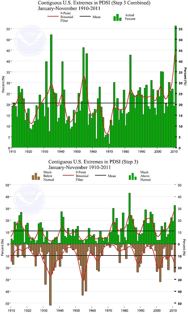
The Palmer Drought Surface Index (PDSI) uses temperature and rainfall to shed light on patterns of wetness and dryness affecting agriculture. The U.S. Climate Extremes Index uses PDSI for its Step 3, which compares the total U.S. areas covered by severe moisture surplus or severe drought (those that fall into either the top or bottom 10% of long-term PDSI records) by adding the two (Step 3 combined, top) or by analyzing each one individually (Step 3, bottom). The year 2011 stands out as having the largest combined area experiencing either very wet or very dry conditions. Click on the dual image for a larger version. (Images from the Climate Extremes Index courtesy NOAA National Climatic Data Center.)
Karoly is now collaborating with David Easterling (National Climatic Data Center) and other NOAA scientists on a CEI-type index that could work for much of the world. “The CEI is very interesting, as it helps us consider changes in extremes of both temperature and rainfall,” says Karoly. “While temperature extremes are showing more hot extremes and less cold extremes in general, for rainfall we are seeing both more wet extremes and more dry extremes, depending on the region. This is happening in Australia and other parts of the world, as well as the United States.”
The output of climate models isn’t usually analyzed with an eye toward the combination of wet and dry conditions captured in indices like the CEI. However, a group of scientists in Italy and China hopes to change that with the hydroclimatic intensity index (HY-INT). This new tool was unveiled in a 2011 Journal of Climate article written by former NCAR scientist Filippo Giorgi (International Centre for Theoretical Physics) and colleagues.
Citing the work of NCAR’s Kevin Trenberth, the authors note that “it is likely that the processes governing the increase in wet and dry events are deeply interconnected.” Because land-based variables such as the Palmer Index are difficult to model, the team decided to focus on extremes of precipitation. However, a lack of rain can’t get any more intense than 0.00,” so the team decided to combine precipitation intensity with the duration of dry spells.
After running a series of 21st-century climate simulations, the team concluded that HY-INT is a “consistent and ubiquitous hydroclimatic signature” of global warming produced by increased greenhouse gases. Indeed, they found that HY-INT goes up through the century for every region simulated, and for all models used, with similar magnitudes and trends across models. The pattern is especially noteworthy in Europe, where models show precipitation growing more intense toward the north and dry spells lengthening toward the south.
North America is another midlatitude continent where climate models have been pointing toward a wetter north and dryer south. It doesn’t take an eagle eye to see this type of pattern reflected in 2011’s U.S. precipitation regime (see map at top). How often the discrepancy will be this dramatic, and where the dividing line between wetness and dryness will tend to set up, are critical questions that remain to be answered.
>>>
Bob Henson connects high-interest weather and climate events with the latest research. Bob is a writer/editor and media relations associate in UCAR Communications.