Three states of water
Concerns about excess and availability span the map
Aug 13, 2012 - by Staff
Temporary impacts to NSF NCAR Road, Parking Lot and Trails
View more information.Aug 13, 2012 - by Staff
August 13, 2012 | From ocean to ocean, the relationships between individual states and their water supplies are changing. Climate scientists have projected serious regional changes over the next 50 years, but many states are already having to make tough decisions regarding their water use and their interaction with water. Among them are Colorado, Louisiana, and Oklahoma. NCAR scientists are involved in collaborative projects in all three states to evaluate the long-term effects of today’s decisions.
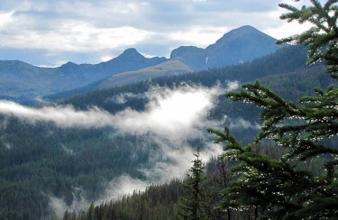
From its high-altitude origins just west of the Continental Divide in the Colorado Rockies, the Colorado River flows onward, providing water for cities and farms throughout much of the southwestern United States. (Photo by Bonnie Carol.)
Recent statewide fires have moved Colorado residents to ask hard questions about the future of water and drought in the state. Models project that the warming atmosphere will change the character of winter storms in the Rocky Mountains, affecting residents and farmers across the Southwest who rely on the storms as their primary water source.
Snowmelt from the high peaks of the Rockies provides more than 80 percent of the water flowing downstream to major cities, including Phoenix and Las Vegas. To better understand how winter storms will be affected by changes in climate, scientists at NCAR’s Research Applications Laboratory are working to perfect the modeling of precipitation, snowpack, snowmelt, runoff, and other variables in the high-altitude basins where the Colorado River begins its southwestward trek to the Pacific.
NCAR's Roy Rasmussen heads the interdisciplinary team behind the Colorado Headwaters Project. (© UCAR. Photo by Carlye Calvin.)
Dubbed the Colorado Headwaters Project, this team of 15 people led by Roy Rasmussen is made up of atmospheric and social scientists and engineers. It also collaborates with researchers at the University of Colorado Boulder, the University of Washington, and the University of Texas at Austin. The goal is to better understand how the complex terrain of the Rockies affects rain and snow on the small scale, and to incorporate that knowledge into larger-scale projections from climate models going decades into the future.
The team used the advanced research version of the Weather Research and Forecasting model (ARW), which reproduced snowfall and other weather variables for four winters from the last decade with high accuracy at points separated by as little as 5 kilometers (about 3 miles). They also drew on results from the NCAR-based Community Climate System Model (which is supported by NSF and the U.S. Department of Energy). Those results indicated that the region’s climate would see a 3.6ºF (2ºC) increase in temperature and a 15% increase in precipitation over recent conditions by 2045–55 if global emissions of greenhouse gases continue to increase at a moderate pace. The group then used the CESM estimates with ARW to determine what would happen on a finer scale.

Colorado’s famed terrain produces wide variations in rain and snow across small areas. To better reproduce these patterns in weather and climate projections, the Colorado Headwaters effort is employing high-resolution models that depict major peaks, ridges, and valleys across the state. (Image courtesy Colorado Headwaters project.)
The results showed that snowfall increased overall by 12% at midcentury compared to the past decade. However, the results varied by altitude: snowpack increased at the highest elevations and decreased at lower elevations.
"Our results show islands of enhanced snow in the highest Colorado peaks, surrounded by areas with more rain and melting," says Rasmussen. Spring melt occurred three weeks earlier than today, and the snowline elevation increased by an average of 660 feet (200 meters). Shifts in runoff and evaporation were also projected. Future studies will consider changes in storm tracks.
These findings suggest that different cities will be affected different ways. In states such as Arizona, the changes could mean severe drops in water access; in Colorado, the results suggest a shorter snow season and a snowpack that melts and evaporates more quickly, even with the potential for heavier snow at the highest elevations. David Gochis, an NCAR scientist who works on the project, puts things into perspective from a water-management point of view: “We will still face significant challenges in water management. There will be more evaporation and more pressure on water supplies, particularly in the summertime,” he adds.
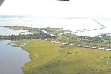
At the northern end of Isle de Jean Charles, 30 families of the Biloxi-Chitimacha-Choctaw tribe hold on to land threatened by environmental and commercial pressures. Extending from the top right of the photo is Island Road, the only means of getting to the island from the mainland. (©UCAR. Photo by Monika Wnuk.)
On the other side of the Continental Divide, waters from eastern Colorado and many other states flow into the mighty Mississippi, eventually spilling into its famed delta in far southeast Louisiana. Here, the rapidly changing coast tells a complex water story pertinent to coasts everywhere.
Hurricanes Katrina and Rita brought attention to the delta’s vulnerability to natural forces, but the daily vulnerability of the coast to geologic and human activity is talked about less often. Natural buffers against storm surge have long been a function of barrier islands, healthy marshes, natural ridges adjacent to bayous, and cypress swamps. In combination with artificial levees, these landscape features have allowed humans to live and work in an otherwise flood-prone area. However, society has also jeopardized the ability of the landscape to repair itself.
Land subsidence (sinking) coupled with a rise in sea level have exacerbated erosion and allowed destructive storm surges to penetrate the coast and move further inland. When humans are not affecting the landscape, then river deltas can work to both erode and replenish barrier islands in a cyclic fashion. However, levees built to divert sediments away from Louisiana’s coast haven’t allowed for this cycle to unfold. Moreover, decades of oil drilling have left open pipelines underwater that encourage the flow of salt water into delicate wetland ecosystems. Unaccustomed to saltwater, entire cypress swamps decay along the coast, further contributing to flooding and erosion.
NCAR’s SOARS program (Significant Opportunities in Atmospheric Research and Science) sent two students to Louisiana this summer to investigate this multifaceted water issue. See the sidebar at the bottom to dive deeper into the specifics of their community-based research.
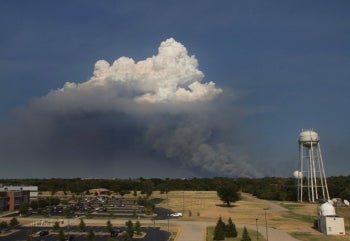
Only months after heavy winter rains erased a severe drought, Oklahoma returned to record heat and bone-dry conditions in the summer of 2012, paving the way for destructive wildland fires. A fire just east of Norman on August 3 spawned this pyrocumulus cloud, photographed from the roof of the National Weather Center. (Photo courtesy James LaDue, NOAA.)
Where Louisiana looks to mitigate the effects of too much water, Oklahoma struggles to make sense of year-to-year variability in precipitation.
“There is nothing steady about rain in Oklahoma,” says Jeffrey Basara, director of research at the Oklahoma Climatological Survey. Basara recalls periods of significant drought in 2000, 2006, 2011, and 2012 and how sharply they contrasted with extreme rainfall events like the record-breaking flash flood in Oklahoma City in 2010. Such variability on short time scales calls attention to future water sustainability in the state.
In Oklahoma, aquifers provide most of the water distributed to homes and businesses. The Arbuckle Simpson Aquifer, located in the south-central part of the state, is the only source of water that supports the various streams, rivers, and lakes in a 500-square-mile area, supplying a total of 39,000 users. Ownership and limits to use of the aquifer are now being disputed by a mix of parties, including landowners who wish to sell the water to neighboring states, a group of citizens concerned about preservation and sustainability of Oklahoma’s water supply, and members of the Chickasaw Nation who claim original rights to the source. Since 2003 the aquifer has been studied more intensively than any other in the state.
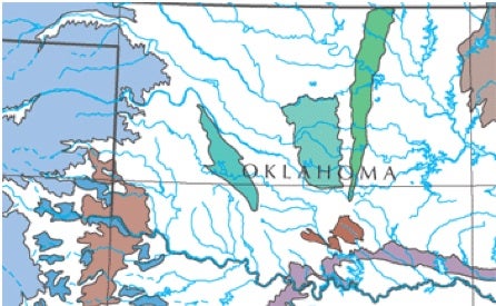
Shown here in light brown, the Arbuckle-Simpson Aquifer is located in south-central Oklahoma. (Map courtesy U.S. Geological Survey.)
Scientists in NCAR’s Earth System Laboratory (NESL) are using an interdisciplinary approach to chart how people value water and perceive drought risk in south-central Oklahoma and whether this lines up with climate projections for future water availability. Environmental anthropologist Heather Lazrus is teaming with climatologist Debasish PaiMazumder and ecosystem scientist Erin Towler on the project.
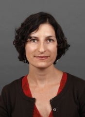
NCAR's Heather Lazrus brings an anthropological perspective to an interdisciplinary study of water use in Oklahoma. (©UCAR. Photo by Carlye Calvin.)
Based on a foundation of anthropological theory, Lazrus is conducting and analyzing interviews in hopes of illuminating the cultural mechanisms through which people understand water-related risk. PaiMazumder is using NCAR’s Nested Regional Climate Model to develop plausible drought scenarios in Oklahoma’s current and future climates through an exploration of drought impact indices (mainly precipitation, temperature, and soil moisture). And Towler is analyzing stream flow patterns in wet and dry years to understand the impact of drought.
Using Lazrus’s findings on how people view water availability and drought risk, PaiMazumder will develop a new index for assessing the damage caused by droughts. The results will be made available to water planners and the public. Also, Towler will identify impacts to drinking water, fishing, and other ecosystem components that rely on water availability.
“Our hope is to communicate the potential of drought in a way that parallels how people understand it,” says Lazrus.
Monika Wnuk, a recent graduate of the University of Chicago, was an intern with NCAR & UCAR Communications in the summer of 2012.
A human issue accompanies the changes in land and water use in coastal Louisiana, where economically vulnerable populations live
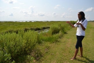
For her 2012 research as a UCAR SOARS protégé, Sandra Maina (Florida International University) worked with residents of far southeast Louisiana and conceptualized a smartphone application to depict the science and the human stories behind their sinking landscape. (©UCAR. Photo by Monika Wnuk.)
on land that is in immediate danger. Among these groups is the Biloxi-Chitimacha-Choctaw Native American tribe residing on the island of Isle de Jean Charles.
Forced by westward expansion in the 1800s onto the southernmost part of the Mississippi Delta, this tribe struggles to hold onto the land that has long sustained it. Out of a population of 80 families a decade ago, the remaining 30 families of Native American descent live on a two-mile strip of land on either side of one road, surrounded by land that has become too soggy for use. Residents can only point to where their family’s cow pastures, forests, and cemeteries used to be. A four-foot dirt levee separates their homes from the Gulf of Mexico. Residents drive almost daily to the mainland on a low-lying road that tends to flood. But relocation would be expensive, and there are other factors keeping the remaining families in place. For example, the region is considered a fishing paradise, and tribal members are constantly at odds with fishermen who set up camps on the island.
Through UCAR’s SOARS program (Significant Opportunities in Atmospheric Research and Science), Sandra Maina, a graduate student in environmental studies at Florida International University, and Frances Roberts-Gregory, a senior in environmental science and anthropology at Spelman College, spent the summer of 2012 conducting interdisciplinary research in this vulnerable community.
Maina and Roberts-Gregory were introduced to local issues by their community mentor, Kristina Peterson, a research associate at the University of New Orleans Center for Hazards Assessment, Response and Technology. Peterson is deeply invested in the community, serving as a pastor at the local Bayou Blue Presbyterian Church and as an activist for the region at conferences across the nation.
Following the guidelines of participatory action research, Maina and Roberts-Gregory asked members of the community to express their needs, then designed their projects accordingly. Maina met with community members on the five most vulnerable strips of land along the coast—Chauvin, Dulac, Dularge, Montegut, and Pointe au Chien—in order to identify points of cultural interest that are at risk of flooding and erosion. Following her summer of fieldwork, she hopes to direct the creation of a smartphone application that would map these places and include a history of each one, along with a video message from a community member. The app would also keep users updated on ongoing restoration projects in the area.
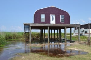
Even some homes and business that were built on stilts to accommodate flooding are now difficult to access at any time. (©UCAR. Photo by Monika Wnuk.)
“Lots of big organizations want to exclude the community,” says Maina. “This smartphone app seeks to include and empower it.”
Roberts-Gregory applied tools from ethnobotany and anthropology to determine which culturally significant plants are threatened by ecosystem changes. Her procedure started with documents from the 1930s that details curatives used by Native Americans in the area, supplemented with conversations with community members who work with the same plants.
Roberts-Gregory describes her experience with participatory action research as “just as complex as the water situation in Louisiana.” Every week brought new conversations, focus groups, content analysis, and new angles to the issues at hand. Although the process took time, she sees community input as essential to community-relevant results.
Both students hope that future scientists continue community-based interdisciplinary projects in the region. From what they’ve seen, residents know the issues and are eager to continue the conversation—and move into action.