Storms in plane sight
Chemists, meteorologists join forces for aircraft-powered study
Oct 4, 2012 - by Staff
Temporary impacts to NSF NCAR Road, Parking Lot and Trails
View more information.Oct 4, 2012 - by Staff
October 4, 2012 | While hail and high winds pounded the terrain below, a unique study this spring kept its focus on the tops of thunderstorms. The DC3 project (Deep Convective Clouds and Chemistry) pulled together chemists, radar experts, cloud physicists, forecasters, and pilots, among other specialists. Their mission: analyze the course of winds, airborne particles, trace gases, and moisture into and out of thunderstorms, with an emphasis on the upper troposphere—the region just below the stratosphere, where storm outflow and lightning can transform the character of the air.
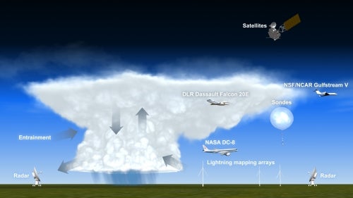
The DC3 field project deployed a variety of airborne and ground-based instruments to study thunderstorms. (©UCAR. This image is freely available for media & nonprofit use.)
“We tend to associate thunderstorms with heavy rain and lightning, but they also shake things up at the top of cloud level,” says NCAR’s Chris Cantrell, one of DC3’s four principal investigators. “Their impacts high in the atmosphere have effects on climate that last long after the storm dissipates.”
Past field projects have had a more singular focus, either on the details of thunderstorms or on the atmospheric chemistry behind them. DC3 is the first to take a comprehensive look at both aspects, including air movement, cloud physics, and electrical activity. Funded by NSF, NASA, and NOAA, the DC3 effort involves more than 300 participants from 26 organizations.
NCAR’s Earth Observing Laboratory coordinated the extensive field work, serving as overall logistics contact for DC3’s ground- and air-based sampling. “DC3 was a very complex project that required the participation of almost every observing facility that our lab manages,” says EOL scientific project manager Vidal Salazar. Without careful coordination of aircraft, radars, radiosonde launches, and other observing platforms, he notes, it wouldn’t have been possible to track the main chemicals of interest for the long intervals and the wide range of altitudes sampled in DC3.
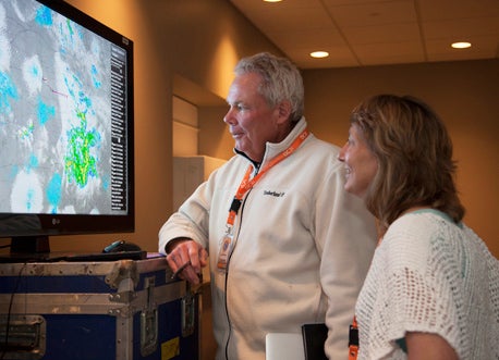
Steven Rutledge (Colorado State University) and Mary Barth (NCAR) survey a composite radar image as a DC-3 mission unfolds. (©UCAR. Photo by Carlye Calvin.)
“One of the things that makes DC3 stand out is the effort to tie together storm dynamics and atmospheric chemistry,” says PI Bill Brune (Pennsylvania State University). “This project has huge potential to improve all kinds of models, from local to regional to global scale.”
One of the key goals of DC3 is exploring the role of thunderstorms in forming upper-atmosphere ozone, a greenhouse gas that has a particularly strong warming effect high in the atmosphere. “When thunderstorms form, air near the ground has nowhere to go but up,” says PI Mary Barth (NCAR). “Suddenly you have an air mass at high altitude that’s full of chemicals that can produce ozone.”
Brune, Cantrell, Barth, and Steven Rutledge (Colorado State University, or CSU) got the inspiration for DC3 after results from a more general 2004 study called INTEX-NA left them puzzled. “We found pollution down low, but the middle altitudes were pretty clean,” says Brune. “Then there was a mixture of air near the top of the troposphere, with signatures of the stratosphere and the boundary layer.” At this topmost height, he says, “a lot of what we expected in amounts of gases didn’t match up. DC3 gave us an excellent opportunity to focus on individual storms.”
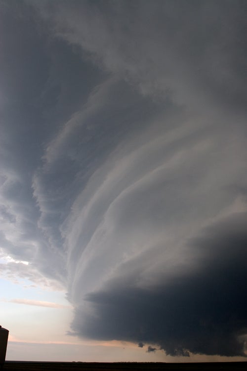
DC3 examined the variety of ways in which air ascending through a tall, intense thunderstorm intersects with the surrounding atmosphere. (©UCAR. This image is freely available for media & nonprofit use.)
Lightning drives much of the chemistry in the upper reaches of thunderstorms. The intense heat of a lightning bolt breaks apart molecules of the two most prevalent atmospheric elements, nitrogen (N2) and oxygen (O2). Some of the nitrogen atoms then combine with one or more oxygen atoms to form nitrogen oxides (NOx), which in turn can react with other chemicals in the presence of sunlight to form ozone. These interactions are well understood at Earth’s surface, but they have not been measured at the top of the troposphere.
“NOx affects ozone photochemistry in ways that we don’t completely understand,” says PI Rutledge. “Nor do we know how much NOx is produced by lightning in a given storm cell.”
The data sets collected in DC3 promise to help answer these and other questions. The study boosted its odds of success by targeting thunderstorms in three widely dispersed regions: northeast Colorado, western Oklahoma and Texas, and northern Alabama. Each target zone has its own flavor of springtime convection, and often storms are active in one area while quiet in another, which allowed the DC3 scientists to move among the focal points as the weather evolved. On the ground, all three study areas featured dual-Doppler research radars, lightning mapping arrays, and balloon launches to measure the state of the atmosphere from the ground to the stratosphere.
“The internal structures of thunderstorms—and the lightning that accompanies them—differ considerably across the country. This in turn affects the chemical processes occurring inside these storms,” notes Brad Smull, NSF program director for physical and dynamic meteorology.
Stationed within easy reach of DC3’s trio of study areas, the Salina Regional Airport in north central Kansas hosted an operations center and three research aircraft:
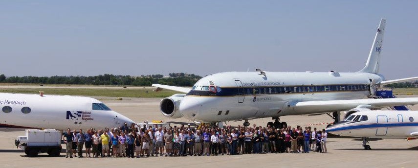
DC3’s three aircraft (from left to right, the NSF/NCAR Gulfstream V, NASA’s DC-8, and a Dassault Falcon 20E from Germany’s aerospace agency, DLR) gather with staff from the DC3 operations center in Salina, Kansas. (Photo by Alison Rockwell, NCAR.)
For each of the sites, scientists will combine aircraft observations with data from the dual-Doppler radars (providing information on cloud particles and three-dimensional winds) and lightning mapping arrays, which enable individual lightning channels to be traced in three dimensions. Some bolts informally dubbed “anvil crawlers” can last for several seconds and stretch for hundreds of kilometers through the upper reaches of a large thunderstorm complex.
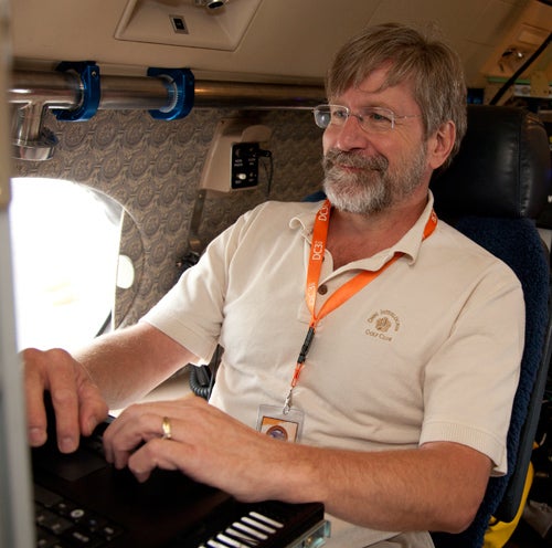
NCAR’s Chris Cantrell monitors chemical sampling from aboard the NSF/NCAR Gulfstream V. (©UCAR. Photo by Carlye Calvin.)
Despite the drought that took hold rapidly this spring across much of the central United States, DC3 managed to gather what appear to be satisfying data sets in all three of its study domains.
“I think some people doubted that we’d be able to get cases with data from at least two aircraft and within coverage of the dual-Doppler networks,” says Barth. As Brune puts it, “That’s the gold standard—did we really sample the inflow and outflow of storms observed simultaneously by dual-Doppler networks? We know we did that in at least some cases.”
The devastating High Park Fire, which raged just west of Fort Collins, Colorado, through much of June, made for some unexpected insights. Rather than obscuring the scientists’ view, the fire’s heavy smoke allowed them to easily track the path of air at heights of around 6–8 kilometers (4-5 miles) as it flowed into storms to the east on June 22. According to Brune, “it’s going to tell us a lot about what’s happening in the middle levels of a storm, where the air is normally pretty clean. I think this has potential to be a textbook case.”
The fire also generated its own thunderstorm at one point, with pyrocumulus atop the blaze powerful enough on June 13 to produce lightning. Rutledge and his colleagues will be analyzing what he calls an unprecedented data set, with dual-Doppler radar capturing airflow into the pyrocumulus. “We’re trying to figure out if the plume became electrified by ice-based processes or through some other mechanism,” he adds.
Along with answering basic questions about thunderstorms’ influence on the atmosphere, DC3 served as a useful test for human forecasters and their computer models. Forecasting leads Morris Weisman and Craig Schwartz (both from NCAR), were joined in Salina by graduate student and early faculty nowcasters from the University of Alabama in Huntsville, University of Oklahoma, Penn State, and Texas Tech University. In addition, forecast teams based in each of the three study areas provided regional expertise to help guide data collection.
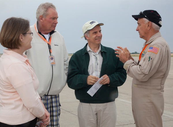
NASA pilot Dick Ewers (far right) briefs Vanda Grubišić (director, NCAR Earth Observing Laboratory), Steven Rutledge (Colorado State University), and UCAR president Thomas Bogdan. (©UCAR. Photo by Carlye Calvin.)
A specially tailored version of NCAR’s Advanced Research WRF (the Weather Reseach and Forecasting model) generated guidance at a resolution of 3 km (1.6 mi), with runs carried out twice daily for periods of up to 48 hours. Each simulation took up to 8 hours on NCAR’s Bluefire supercomputer. The runs included artificial tracers that showed where air at various levels was headed.
The WRF-ARW runs also served as the most extensive use to date of a promising system for assimilating data based on the ensemble Kalman filter (a statistical technique for handling uncertainty in observations and forecasts). “This is one of our priority projects, so it was great to be able to test it out in a research setting,” says Weisman. Computer models from Texas Tech University and NOAA’s National Severe Storms Laboratory also helped guide the field work.
—Bill Brune, Pennsylvania State University
DC3’s data sets will help researchers better understand how storms produce lightning as well as how to use lightning mapping data to improve storm forecasts and warnings. At CSU, two of Rutledge’s graduate students are hunting for relationships that might help predict whether a given storm will tend to produce intracloud versus cloud-to-ground flashes, which has implications for NOx production. Their findings will help test the performance of a WRF-ARW algorithm that predicts lightning frequency.
Although the DC3 team prowled much of the nation’s heartland in search of storms, it’s just as well that severe weather avoided Salina, since the airport’s hangar could only hold two of the three aircraft at any one time. The heat didn’t stay away, though: temperatures at the airport soared as high as 110°F toward the close of the project. Says Weisman: “It felt like a furnace.”