Rounding up severe weather
An armada of tornado researchers builds a moveable field study
Sep 11, 2009 - by Staff
Sep 11, 2009 - by Staff
1 September 2009 • Each spring, hundreds of storm chasers prowl the Great Plains. Though many share their observations through ham radio, cell phones, or wireless Internet, most of these groups go where they please, each hoping to grab a dramatic snippet of video or some useful bits of data. This year they were joined by what was perhaps the largest array of vehicles ever deployed for an atmospheric study. Although conditions were less than ideal for stormy weather, the second Verification of the Origins of Rotation in Tornadoes Experiment (VORTEX2, or V2) captured one tornado in unprecedented detail, as well as a number of potentially tornadic thunderstorms that never made the grade. The team could learn as much from the nonproducers as the producer, and there's another spring yet to come.
The $12 million project, funded mainly by NSF and NOAA, is being run by a steering committee of eight veteran tornado researchers, rather than one or two principal investigators. That arrangement reflects the unusually strong teamwork needed to pull together such a project. More than 50 vehicles were on the road for five weeks, spanning a study area that stretched from Texas to southern Minnesota.
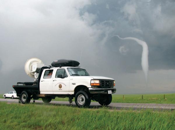
 A W-band radar deployed by the universities of Oklahoma and Massachusetts A W-band radar deployed by the universities of Oklahoma and Massachusetts captured the end stages of the 5 June tornado in Goshen County, Wyoming. (Photo by Robin Tanamachi, University of Oklahoma.)
On each "go" morning, participants headed out to a potentially stormy area, eventually zeroing in on a county-sized target where a tornadic supercell was deemed possible over a several-hour window. The teams spread across the target area to form a dense set of observing platforms as the storm passed, then reconvened by late evening, typically hundreds of miles away from the day's starting point. As NCAR participant Timothy Lim observed, "It's hard to get your laundry done when you don't know what state you'll be in by nightfall."
The original VORTEX experiment, conducted in the springs of 1994 and 1995, provided a tantalizing taste of what scientists could learn about tornadoes through a dense mobile network of instruments. Though it produced groundbreaking data, the study also led to many more questions, says Roger Wakimoto, director of NCAR's Earth Observing Laboratory and one of the principal investigators for the first VORTEX. "We still don't know the origins of tornadogenesis—whether it starts from the storm and descends with time or starts from the ground and builds up with time. These are really fundamental questions," Wakimoto says.
One finding from the first VORTEX was that strong contrasts in temperature and moisture—too small to be seen by standard observing networks—appeared to play a key role in tornado formation. Several theories emerged from these findings, but scientists recognized early on that it would take an even larger field program to clarify the processes that allow only a small fraction of supercellular thunderstorms to bear tornadoes.
Major advances in technology pushed V2 far beyond the bounds of its predecessor. The first Doppler on Wheels (DOW) mobile radar was deployed near the end of the 1995 season of VORTEX, just in time for that project's most intense tornadoes. However, at least two Doppler radars are needed to capture the winds of a severe thunderstorm in three dimensions. Such data have been gathered in recent years by a growing family of DOW units, which are now an NSF observing facility managed by NCAR visiting scientist Joshua Wurman at the Boulder-based Center for Severe Weather Research (CSWR).
Other sets of mobile Doppler radars, each with its own specifications and strengths, have emerged, such as the Shared Mobile Atmospheric Research & Teaching (SMART) Radar, a collaboration of NOAA's National Severe Storms Laboratory, Texas A&M and Texas Tech universities, and the University of Oklahoma (OU). All of these were brought into the fold for V2, working as a group for the first time. Joining 10 radars in the field were radiosonde platforms from NCAR and NSSL, plus an array of ground-based systems. These included 24 Stick- Nets—quickly deployable surface weather stations—plus 14 "tornado pods" and 10 vehicle-based weather stations. Often separated by a kilometer or less, the surface stations formed a tight mesoscale network (mesonet).
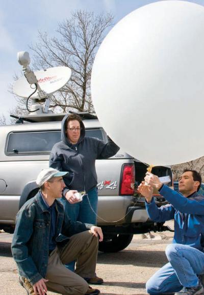
 Left: EOL’s Bill Brown, Jennifer Standridge, and Tim Lim work on MGAUS (Mobile GPS Advanced Upper-Air Sounding System), which was used to launch weather balloons during VORTEX2. (Photo by Carlye Calvin.)
Communications were critical to the success of V2, with cell phone networks sketchy across parts of the Great Plains. "I think we were all surprised how well the communications worked," says Paul Markowski (Pennsylvania State University, or PSU). Redundancy helped: the project employed multiple cell networks, as well as a Web-based chatroom program dubbed SASSI, or Situational Awareness for Severe Storm Intercepts. The software was developed specifically for the project by V2's Erik Rasmussen (Rasmussen Systems). SASSI depicted where each observing platform was stationed at any given time, which allowed radars and mesonet vehicles to adjust their locations as needed to gather the best collective data. The SASSI files also serve as an invaluable archive for later analysis.
"I was impressed with how well the vast majority of observing systems were able to converge on a storm, collect data simultaneously, and keep up with storms, even on road networks that were poor to mediocre," says Markowski. Guiding the team were field coordinators on the road as well as forecasters at NSSL and NCAR, with special storm-resolving model runs carried out on supercomputers at the National Weather Center and NCAR's Computational and Information Systems Laboratory.
V2 was deliberately scheduled for peak season in the world's most prolific zone for tornado production. Yet tornadic storms virtually disappeared during the project's first weeks, as moisture was shunted toward the Gulf of Mexico and the jet stream lifted toward Canada. For the first time in memory during the heart of storm season, NOAA's Storm Prediction Center went nine days (17-25 May) without issuing a single tornado or severe thunderstorm watch.
The project's luck changed on 5 June, as V2 deployed more than 15 minutes in advance of a tornado that formed in far southeast Wyoming's Goshen County (see photo above), at the edge of the project domain. Classified as EF2 on the enhanced Fujita scale—a rating confirmed in part through V2 radar data—it instantly became the best-documented twister in history. "The dual-Doppler data alone would make this a rare case," says PSU's Yvette Richardson.
One of the Doppler units on the scene in Wyoming was a mobile phased-array radar from the Naval Postgraduate School deployed by OU's Howard Bluestein, who is on sabbatical at NCAR. The radar, now in its third year on the plains, gathered full-volume (3-D) scans every six to seven seconds at close range throughout the life of the Goshen County tornado. "The analysis of this dataset in conjunction with data from all the other radars, including two polarimetric radars, will likely yield new insights into tornado formation and stimulate numerical modelers to see if they can simulate what we have observed in nature," says Bluestein.
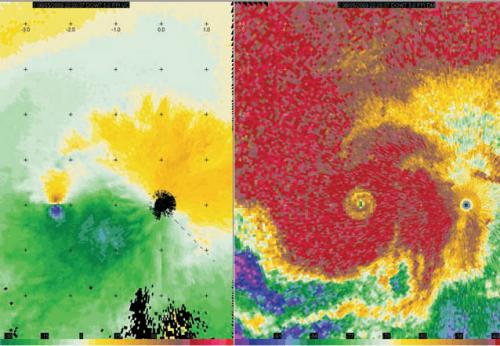
 These radar-derived depictions of velocity (winds) and reflectivity (precipitation) from a Doppler on Wheels (DOW) unit show circulation around the 5 June tornado in Goshen County, Wyoming, at a height of about 200 meters (660 feet). Dots are spaced every 1 km. The Rapid-Scan DOW unit captured data on this tornado every eight seconds from as close as 350 meters (1,160 feet) with a resolution as fine as 5 meters (17 feet). (Image courtesy Center for Severe Weather Research.)
The nontornadic cases from V2 are also drawing keen interest. Current mesoscale models have trouble depicting the small pools of cool, moist air that descend from severe storms and that appear to help trigger tornadoes. The V2 team gathered wind, temperature, and moisture data from a number of these cold pools, including several from storms that developed strong rotation but no tornadoes. "These ‘tornado failure' cases are important for comparison," says Richardson, "so we can decipher the subtle differences between tornadic storms and those that develop in a very similar way up until the very end."
Another V2 coup occurred on 26 May in north Texas, where the project snagged the best-ever dataset on a left-moving supercell. "Left movers," which often rotate anticyclonically, are the less-studied members of diverging pairs of storms that often emerge when severe thunderstorms split in two. Right movers, which tend to rotate cyclonically, are more likely to produce tornadoes.
VORTEX2 drew a swarm of public followers, including more than 6,000 people subscribed to the project's Facebook page and Twitter feed and many thousands more who watched daily updates on The Weather Channel. When it comes to results, though, V2 fans—and the scientific community—will have to be patient: it could be years before the main findings emerge.
"We're not expecting ‘Eureka!' data," says CSWR's Wurman, whose mobile radars had already sampled more than 140 tornadoes before V2. "If there were low-hanging fruit, it would have been plucked already. The features we're looking for are subtle, and they'll only come out through an arduous and complicated synthesis of data."
The V2 researchers will be at it again in the spring of 2010. They're hoping that Federal Aviation Administration officials will approve a set of unmanned aerial vehicles, operated by the University of Colorado in Boulder, that would fly through storms across part of the V2 domain. Otherwise, "operations in 2010 will be very much like those in 2009, and we'll benefit from the experience we gained this year," says NCAR's David Dowell, one of V2's two field coordinators. "I can't emphasize enough the excellent work of the individual teams. They kept a positive attitude throughout the project, despite driving long miles and working in a weather pattern that was mostly unfavorable for our target phenomenon."
The 2010 field campaign will start a few days earlier, enhancing the scientists' chances of tornadic success even as it adds to their mileage. All told, V2 vehicles traveled more than 800,000 kilometers (500,000 miles). Participants had only three days in five weeks when they weren't traveling or intercepting storms. They also filled more than 4,400 hotel rooms, which kept logistics coordinator Ling Chan on the phone for uncounted hours of reservations-making.
Still, the participants managed to drive, eat, and sleep without major incident, and close to 50 students got valuable field experience. The V2 organizers maintain that a rootless armada is their best shot at solving the mysteries of tornado formation. Had the team followed the traditional model and returned to a fixed base each night, they might have gotten data on only one or two supercells instead of more than a dozen, according to Markowski. "Though it added complexity to the logistics and was physically demanding at times," he says, "the fully nomadic aspect of VORTEX2 really paid off."