Watching for Modoki
Oct 12, 2009 - by Staff
Temporary impacts to NSF NCAR Road, Parking Lot and Trails
View more information.Oct 12, 2009 - by Staff
Bob Henson, UCAR Communications | 12 October 2009 • Just when it looked as if a traditional El Niño was getting its sea legs, the event is now looking a bit less canonical. Over the last month, sea-surface temperatures (SSTs) off the coast of Ecuador and Peru have dropped below average—not exactly the hallmark of a robust event. But we have some clue of what might be happening, thanks to a cluster of researchers exploring an important subtype called El Niño Modoki (from the Japanese for "similar but different").
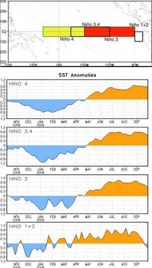 Top: the regions used to define El Niño and La Niña events. Below: SST anomalies (degrees C) in various Niño regions over the last year. (Images courtesy NOAA, drawn from its Weekly ENSO Update.)
First things first: there is indeed an El Niño under way right now. SSTs across most of the central and eastern Pacific are running about 0.5 to 1.5°C warmer than average (0.8 to 2.4°F), as shown in NOAA's weekly 7-day average. The event is still expected to strengthen to at least moderate levels, as shown in the ensemble of forecast models summarized in NOAA’s latest ENSO advisory (8 October) and its weekly update, issued each Monday.
The details are a bit more devilish, as seen in the graphic at right. The recent warming is actually strongest in the central Pacific (region Niño 4, which straddles the International Date Line). In contrast, a classic El Niño shows the strongest warming on its eastern end (region Niño region 1+2).
How different is it?
The western bias to this autumn’s warming pattern is what brings El Niño Modoki to mind. The label was initially coined to describe a 2004 El Niño by Toshio Yamagata (Japan Marine Science and Technology Center). It was then adopted by Karumuri Ashok and colleagues in a 2007 Journal of Geophysical Research paper to refer to central-Pacific–weighted El Niños more generally. Ashok is now at the Asia-Pacific Economic Cooperation group's APEC Climate Center in Korea.
The concept made it into the U.S. press this past summer, when Hye-Mi Kim, Peter Webster, and Judy Curry, all of the Georgia Institute of Technology, released a paper in Science (3 July 2009) on how Modoki (referred to in the paper as “central Pacific warming”) might affect Atlantic hurricane formation in a different way than a conventional El Niño (“eastern Pacific warming”) would. In short: while most El Niños tend to inhibit Atlantic hurricanes, the Modoki variety, with its peak warming displaced further west from the Atlantic, appears to leave more room for a bumper crop in at least some years, such as 2004.
Will the 2009–2010 event blossom into a Modoki? Nobody knows for sure. Curry put her guess on the odds at 50-50 in a July interview. NOAA and other major centers that issue El Niño projections haven’t yet begun to use the Modoki concept in their routine outlooks. However, the El Niño Modoki Index (EMI) has worked its way into an experimental forecast from Australia’s Bureau of Meteorology, and the APEC Climate Center employs the EMI as part of its own experimental 1-to-7-month outlooks.
In an e-mail, Ashok told me that the last few weeks have brought some signs of a Modoki in the making, including the location of the event's maximum warming in the central Pacific and the associated variations in the zonal (west-east) component of low-level winds. However, other signals, such as ocean temperatures below the surface, appear to support a traditional El Niño. “We have to wait and see whether the pattern shifts to a typical winter Modoki by December or not,” he wrote.
Olympic hopes
For North Americans, the answer to “What does this mean for me?” is equally uncertain. In a 2008 paper in Climate Dynamics, Hengyi Weng (of Japan’s Frontier Research Center for Global Change) and coauthors found that Modoki tends to produce the classic precipitation signal associated with El Niño winters in western North America—wet to the south, dry to the north. But a "true" El Niño is more likely to bring above-average moisture further north into the Pacific Northwest.
That would be good news for the 2010 Olympics, which are scheduled for February in Vancouver and Whistler, British Columbia. As a rule, El Niño tends to bring this area decreased snowfall as well as warm temperatures, neither of which is good for a ski area where temperatures can hover close to freezing. Thus, Olympics organizers might hope that Modoki is a no-show.
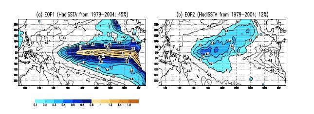 These graphics show the relative influence of classical El Niño events (left) and El Niño Moki (right) on overall variability in sea-surface temperatures across the tropical Pacific between 1979 and 2004. (Images courtesy Karumuri Ashok, APEC Climate Center.)