COSMIC-2 atmospheric observing system slated to blast off next week
Innovative satellites will improve hurricane forecasts, space weather monitoring
Jun 19, 2019 - by David Hosansky
Temporary impacts to NSF NCAR Road, Parking Lot and Trails
View more information.Jun 19, 2019 - by David Hosansky
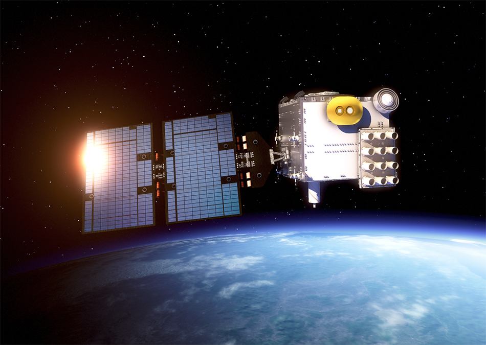
An artist's rendering of a COSMIC-2 satellite. (Image: Surrey Satellite Technology Ltd.)
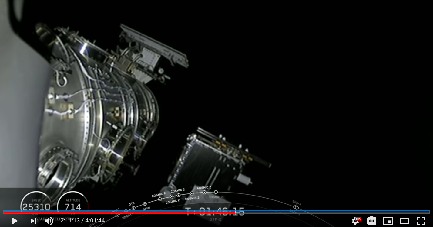
Update - June 24, 2019 | Launch and deployment into low-Earth orbit were successful. Video of the full U.S. Air Force Space Test Program-2 mission, including launch of the six COSMIC-2 satellites is available via SpaceX on YouTube.
A constellation of small satellites that are scheduled to blast into orbit next week will lead to better hurricane forecasts and provide critical information about upper atmospheric disturbances that can affect global communications systems and electrical grids.
The Constellation Observing System for Meteorology, Ionosphere, and Climate-2 (COSMIC-2) system consists of six small satellites with an array of innovative sensors to probe large areas of the atmosphere. The international project is a partnership with the National Oceanic and Atmospheric Administration (NOAA), the Taiwan National Space Organization (NSPO), the U.S. Air Force, the National Science Foundation, and the University Corporation for Atmospheric Research (UCAR). The system is known as FORMOSAT-7 in Taiwan.
The satellites will take up to 6,000 soundings, or vertical profiles, of the atmosphere every day, from the Earth's surface to more than 30 miles high. This will provide critical information about remote regions that are difficult to measure with traditional instruments, enabling forecasters to provide better weather predictions, particularly of the timing, location, and intensity of tropical cyclones and other destructive storms across much of the globe.
UCAR's COSMIC-2 Data Processing Center will process the satellite data and make them freely available in near real-time to meteorological and academic organizations worldwide.
"COSMIC-2 will open a new window on the atmosphere, generating consistent measurements of water vapor and other atmospheric properties over places where data have been scarce, including vast stretches of ocean," said Bill Schreiner, director of the UCAR COSMIC program. "These data will enable meteorologists to provide vulnerable communities with more detailed and accurate forecasts, helping to save lives and property."
The new system follows the COSMIC-1 (FORMOSAT-3) mission, an array of six low-cost microsatellites launched in 2006 that demonstrated its value for improving forecasts by supplying detailed observations of atmospheric conditions globally. The COSMIC-2 satellites, each about the size of a washing machine, will provide twice as many soundings as the original system. The new system will focus observations on lower latitudes, between 40 degrees North and 40 degrees South, where tropical cyclones organize and strengthen.
In addition to improving weather forecasts, COSMIC-2 will monitor the ionosphere high above Earth and keep officials apprised of space weather disruptions. The satellites will also provide highly accurate measurements of tropical temperatures, helping scientists better understand long-term variations in Earth's climate.
As part of the U.S. Air Force Space Test Program-2 (STP-2) mission, COSMIC-2 is scheduled for launch on June 24 on a SpaceX Falcon Heavy rocket that will lift off from Kennedy Space Center in Cape Canaveral, Florida. UCAR will begin disseminating the data a few months later, once the satellites are in orbit and the instruments are calibrated and tested.
"We are looking forward to sharing these unprecedented views of the atmosphere with our partners in research and forecasting," said UCAR President Antonio Busalacchi. "The observations taken by COSMIC-2 will provide far-reaching benefits for society."
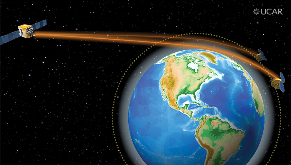
COSMIC-2 will probe Earth's atmosphere with a technique known as GNSS radio occultation. This measures the degree to which the radio signals sent by Global Navigation Satellite Systems (GNSS, which includes GPS) satellites bend and slow as they pass through the atmosphere. The greater the bend and delay, the denser the atmosphere.
The measurement can be further processed into information about temperature, pressure, and humidity, providing considerable data about a large volume of the atmosphere, from near-Earth orbit down to the surface.
"The National Science Foundation funded the initial fundamental science that has now culminated in this project that will yield such valuable data," said Bill Easterling, NSF's assistant director for Geosciences, which funded a portion of COSMIC-2. "We look forward to seeing what the new satellites can tell us about the weather and climate of the tropics, for instance how variations in temperature and moisture contribute to the evolution of hurricanes."
Measurements made by GNSS radio occultation are also highly accurate and can be used to calibrate other satellite observations, an important form of quality control.This accuracy is valuable to hurricane forecasters, who are interested in measurements of water vapor, the fuel that drives hurricanes and other tropical cyclones, at different heights in the atmosphere. While other observing systems over the oceans — as well as weather prediction models — often underestimate reservoirs of moisture stored in the lower atmosphere, the first-generation COSMIC (FORMOSAT-3) satellites demonstrated that radio occultation could provide much more accurate information about how much water vapor was available to fuel a forming cyclone.
COSMIC-2 will provide even more of this information than its predecessor system, since its measurements will be focused over the tropics, where hurricanes and typhoons are born. An improved antenna on the satellites will also enable higher-quality measurements, further improving forecasts and providing officials with better information as they make consequential decisions such as whether and where to order evacuations.
"One of the exciting things about COSMIC-2 is that it will generate a wealth of information about conditions near the equator," said Ying-Hwa "Bill" Kuo, director of UCAR Community Programs, who helped oversee development of the new system. "This can revolutionize tropical cyclone forecasts."
Leading meteorologists say the observations will be important for their forecasts.
“COSMIC-2 will gather information about the vertical temperature and humidity of the atmosphere in the tropics, which holds most of the moisture that drives global weather patterns,” said Louis W. Uccellini, director of NOAA’s National Weather Service. “The high quality and large number of observations from the COSMIC-2 data stream will improve the accuracy of our weather forecast model outputs for our national and global areas of responsibility."
Another notable benefit of the satellites is their ability to measure electron density in the ionosphere. This will provide space weather forecasters with near-real time information about disruptions in the outer atmosphere that affect satellite operations and navigation systems, potentially knocking out communications and other technologies that society relies on.
Satellite bus
Instruments
Each COSMIC-2 satellite will carry these three instruments:
The data from these instruments will be transmitted to a network of ground stations and then processed and disseminated by UCAR to operational users worldwide through the World Meteorological Organization’s Global Telecommunications System. COSMIC-2 data products will also be freely available to the scientific community via UCAR’s COSMIC Data Analysis and Archive Center.