Steering a (virtual) hurricane: New model gives scientists more control
Researchers can better quantify the range of possible impacts from landfalling storms
Mar 30, 2020 - by Laura Snider
Temporary impacts to NSF NCAR Road, Parking Lot and Trails
View more information.Mar 30, 2020 - by Laura Snider
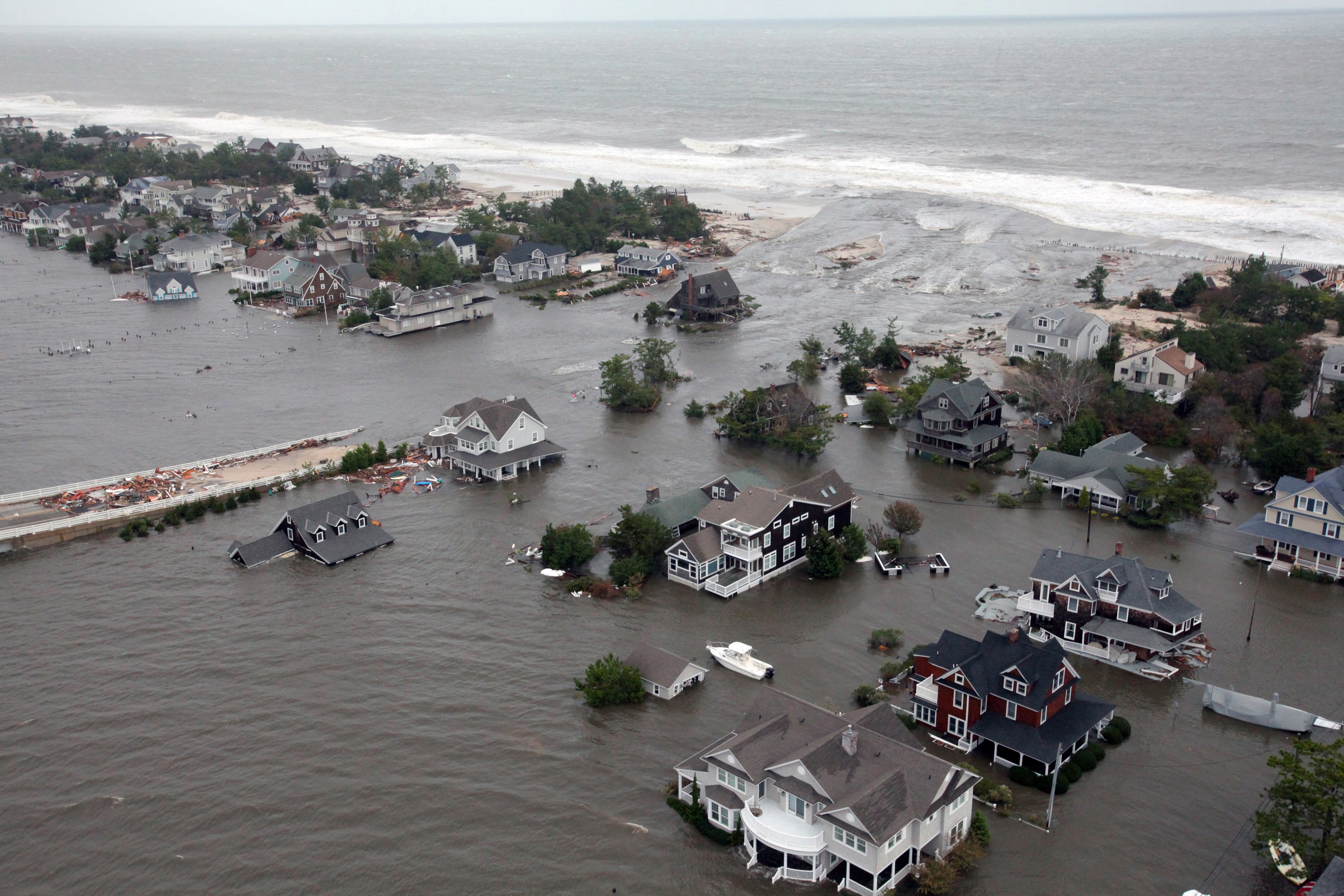
Damage to the New Jersey coastline, which was hit hard by storm surge from Sandy on Oct. 30, 2012. (Image: U.S. Air Force)
What if Sandy had dealt New Jersey a glancing blow in 2012 instead of hitting it nearly head on? Or if the historic storm had made landfall farther south or north? What if the storm was smaller, slower, or more intense? How would the impacts change?
Answering these questions using dynamical weather models, like the widely used Weather Research and Forecasting (WRF) model based at the National Center for Atmospheric Research (NCAR), is a challenge. While these models can simulate hurricanes in detail, they are primarily designed to give the best possible prediction of a hurricane's track and evolution given the current conditions in the model, not to answer what-if scenarios. As a result, scientists have very little control over how the storms in the model propagate.
A new tool developed by NCAR scientists is changing that. The Hybrid WRF Cyclone Model (HWCM) allows scientists to create a virtual idealized storm (prescribing storm characteristics such as size and intensity), precisely place that storm where they want it inside the model, and then steer the storm toward land, giving them a much greater degree of control over how and where the simulated hurricane makes landfall.
This ability to steer virtual storms allows researchers to characterize a range of possible impacts from a landfalling hurricane at a particular location. Using HWCM, scientists can subject the same location to storms coming from many different angles, which can significantly affect storm surge, as well as a range of storm sizes, intensities, and forward speeds. Together, these simulations can better characterize the possible risks to coastal communities.
“It can be very challenging to study the possible impacts of hurricanes by looking only at the historic record,” said NCAR scientist Cindy Bruyère, who led the development of the new model. “If you look along any 50 miles of coastline, you might only see one hurricane a decade. Being able to realistically model these storms can give us a much more complete picture of the possible impacts.”
The development of HWCM was supported by the National Science Foundation, which is NCAR’s sponsor, and by the Insurance Australia Group Limited.
Risk managers, community planners, insurers, and others have long been interested in quantifying the risk of hurricane damage to communities. Traditionally, this has been done using statistical models, which characterize relationships among phenomena in the past – for example, the rainfall typically associated with a certain size or intensity of storm - and then apply that knowledge to make predictions about the future.
While statistical models are useful, they have limitations because they tend to look at only one variable at a time and use historical storms as their benchmarks. However as the climate changes, storms could form in the future that have no analog in the historical record, including hurricanes that make landfall further toward the poles than ever before.
By contrast, dynamical models, such as WRF, actually use our understanding of physical relationships in the world – how oceans influence the atmosphere, and how atmospheric instabilities may spawn a storm, for example – to simulate hurricanes themselves. These kinds of models can provide stakeholders with a wealth of detailed information about the way the storm interacts with the other realistic environmental features in the model, such as the coastal topography.
But getting information about how a particular kind of storm might affect a specific location is challenging. That’s because the way the storm propagates after it has formed in the model, including its track and where (or if) it makes landfall, depends on the model's physics, which create weather patterns based on environmental conditions. For example, a high-pressure area that forms over the coast in the model could hold a storm at bay or bend its course.
Bruyère and her colleagues sought to create a dynamical model that could be used to assess the hazards of hurricanes by giving the modeler control. The result was the Hybrid WRF Cyclone Model.
“I don’t want weather patterns in the model to impact my storm; I want to control where my storm makes landfall,” she said. “We have developed the capability to put a mature storm exactly where we want it and to subject it to different background flows from simulation to simulation, forcing the storm to make landfall in different ways. Now we can start to see a range of possible impacts from the same storm.”
HWCM allows modelers to spin up an idealized hurricane within WRF – a sort of storm in a box – and then place the mature storm into WRF’s real-world domain. Once placed, the modeler can prescribe the background wind flow and direction, essentially steering the storm while still allowing it to interact with the surrounding environment as it evolves.
The research team recently described the new modeling capability in detail in the journal Weather and Climate Extremes. They have also begun experimenting with what the tool can teach them, including a detailed study of how the landfall angle of a Sandy-esque storm could alter the storm surge impacts along the New Jersey shore.
Part of Sandy’s notoriety was related to the peculiar left hook the storm made before landfall, allowing it to hit the shore perpendicularly, from the east. Historically, storms in that region have typically come up from the south, strafing the shoreline as they travel north.
The preliminary results of the research using HWCM found that storm angle has a significant impact on storm surge impacts, and that storms with perpendicular approaches produce larger surges and more inland flooding. They also found, however, that the exact location of landfall is important as well and that some areas of the New Jersey coast were particularly vulnerable to storm surge, regardless of approach angle.
Bruyère has also used the new modeling capability to look at some of the possible impacts of climate change, including storms forming over warmer oceans and storms migrating poleward. In one case, the team examined how cyclones striking northeastern Australia might change as sea surface temperatures warm. They found indications that increased sea surface temperatures caused simulated storms to penetrate farther inland, with more precipitation and larger wind fields. Bruyère said that more research with HWCM can help scientists better quantify the potential impacts of climate change on tropical cyclones.
“With this model, we can look at storms that are not in our history,” Bruyère said. “We can place storms over warmer water than we typically have or near parts of the coast where storms don’t typically make landfall, but which may be impacted in the future. The results will help us plan for some of the risks of a changing climate.”