NCAR scientists recruiting the public to help ground-truth hurricane risk app
App aims to provide personalized risk information for people in storm-vulnerable areas
Nov 10, 2021 - by Laura Snider
Temporary impacts to NSF NCAR Road, Parking Lot and Trails
View more information.Nov 10, 2021 - by Laura Snider
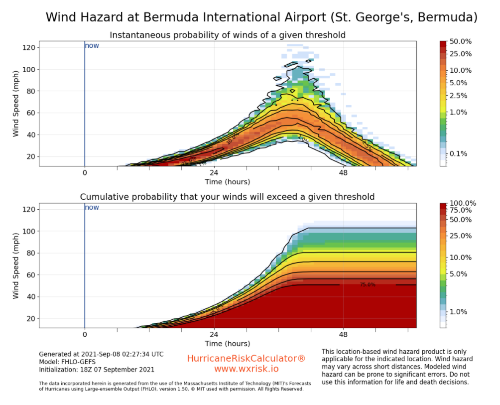
Example of the model output from Forecasts of Hurricanes Using Large-ensemble Outputs (FHLO) that drives the HurricaneRiskCalculator. This type of information will be available in a technical view of the app. For non-technical users, the app will provide easy-to-use tools to help them understand how strong winds may gust at their location and when those winds may arrive.
When a hurricane is threatening the coast, forecasters, emergency planners, and the public tend to focus on the storm's intensity and likely location of its landfall when considering whether residents should evacuate.
Now a team of scientists led by the National Center for Atmospheric Research (NCAR) wants to change the conversation — and they need the public’s help. The researchers are test-piloting the first phase of a web application that will ultimately allow users to get tailored information about the likely storm impacts at their specific locations, including information on the likelihood of high winds, when those winds will arrive, and how much damage they may cause to their homes.
“We’re trying to shift the public’s attention from just considering the storm’s intensity and track to thinking about what the impacts are going to look like at their homes,” said NCAR scientist Jonathan Vigh, who is leading the project. “Storm hazards affect each structure differently. It’s possible that one family may need to evacuate while their neighbors may be able to stay. I can imagine a future where, based on tailored risk outputs, local emergency officials could evacuate people by address rather than by zip code or surge zone.”
The vision for the HurricaneRiskCalculator®️ web app, which Vigh and his collaborators have been working on for several years, is to allow users to enter their addresses along with information about their homes, including height and age, as well as the types of windows, siding, and roofing material used. The app will combine that data with wind forecasts to project the types of structural damage that are likely to occur with the aim of giving the user actionable information that could help them to decide whether to evacuate. (The scientists underscore that the app does not yet provide storm surge and flooding information and it should not be used for critical decision-making. Residents in storm-prone regions should still heed the evacuation advice of local authorities.)
For now, the research team wants to test the first phase of the web application: tailored wind forecasts. The capability relies on a new wind forecasting system from the Massachusetts Institute of Technology (MIT) called Forecasts of Hurricanes Using Large-ensemble Outputs, or FHLO, that is able to deliver more precise information than is currently available about the probability that winds at a particular location will exceed a particular threshold.
The HurricaneRiskCalculator®️ will not yet provide information to the user on potential structural damage, though the app developers hope to roll that feature out in the coming months. For now, the researchers would like to collect information about the users’ homes before the next storm strikes. The plan is to use this information to calculate the expected damage on the back end and then ground truth those projections.
“Our goal in this pilot is to collect the data vital for validating and calibrating the app’s outputs,” Vigh said. “We’ll get the predicted damage outputs from the tool and compare that to what actually happened at the house.”
Once the team has demonstrated the value of tailored wind forecasts, they plan to include other hurricane hazards, such as storm surge and flooding.
Anyone living in an area vulnerable to hurricanes who is interested in contributing to this research project is encouraged to sign up for the HurricaneRiskCalculator by visiting wxrisk.io.